MyTopo
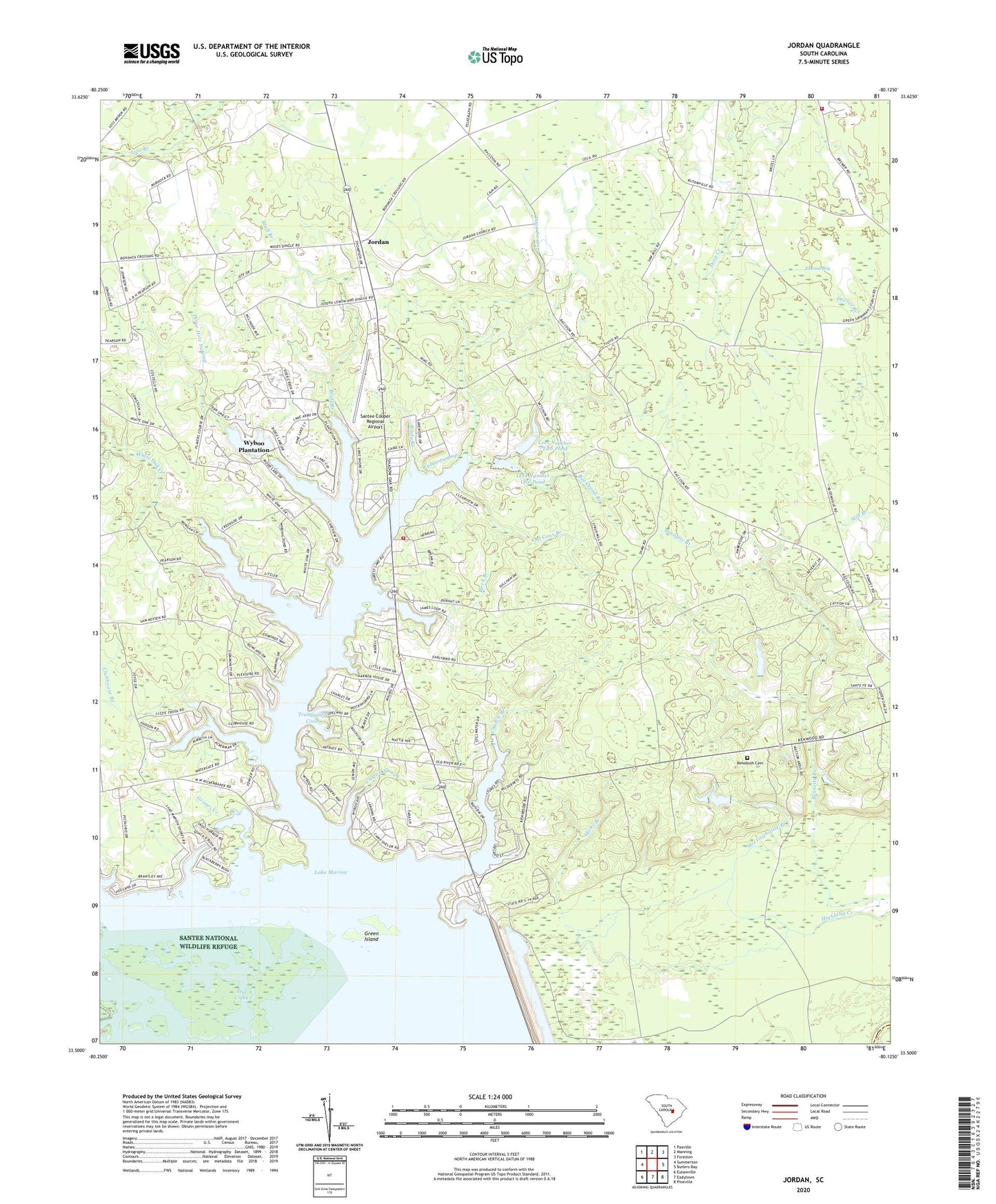
Jordan South Carolina US Topo Map
Couldn't load pickup availability
2024 topographic map quadrangle Jordan in the state of South Carolina. Scale: 1:24000. Based on the newly updated USGS 7.5' US Topo map series, this map is in the following counties: Clarendon, Berkeley. The map contains contour data, water features, and other items you are used to seeing on USGS maps, but also has updated roads and other features. This is the next generation of topographic maps. Printed on high-quality waterproof paper with UV fade-resistant inks.
Quads adjacent to this one:
West: Summerton
Northwest: Paxville
North: Manning
Northeast: Foreston
East: Butlers Bay
Southeast: Pineville
South: Eadytown
Southwest: Eutawville
This map covers the same area as the classic USGS quad with code o33080e2.
Contains the following named places: Bennets Branch, Bennetts Branch, Big Branch, Birch Branch, Bluff Branch, Bonanza, Buckhead Branch, Camp Cooper, Camp Shelor, Carroll Slough, Central School, Church Branch, Clarendon County Rural Fire Department Station 15, Clarendon County Rural Fire Department Wyboo, Clubhouse Branch, Cypress Church, Dean Swamp, Deep Creek School, Duffie School, Eagle Point, Elwood Bay, Felton Rosenwald School, Frierson, Green Island, Green Savanna School, Green Savannah Church, Grimes Creek, Hicks Branch, Jordan, Jordan Church, Jordan School, Lees Number One Pond, Lees Number Three Pond Dam, Lees Number Three Pond Dam D-3506, Lees Number Two Pond, Lib Pines Lake, Lizzies Branch, Macedonia Church, Manning Division, McCoys Branch, Meetinghouse Branch, Mount Zion Church, New Zion Church, Pine Grove School, Potato Creek, Rehoboth Cemetery, Rehoboth Church, Rooty Branch, Rowland, Saint Matthews Church, Saint Peters Church, Santee Cooper Regional Airport, Shad Moss village, Shaw Pond Dam D-3509, Society Hill Church, Society Hill School, South Carolina Noname 14010 D-3505 Dam, South Carolina Noname 14011 D-3504 Dam, South Carolina Noname 14013 D-3503 Dam, Still Creek, Three Hole Swamp, Three Square Pond Church, Tranquility Cove, Union Church, White Oak, White Oak Branch, White Oak Creek, Wyboo Census Designated Place, Wyboo Church, Wyboo Plantation, Wyboo Swamp