MyTopo
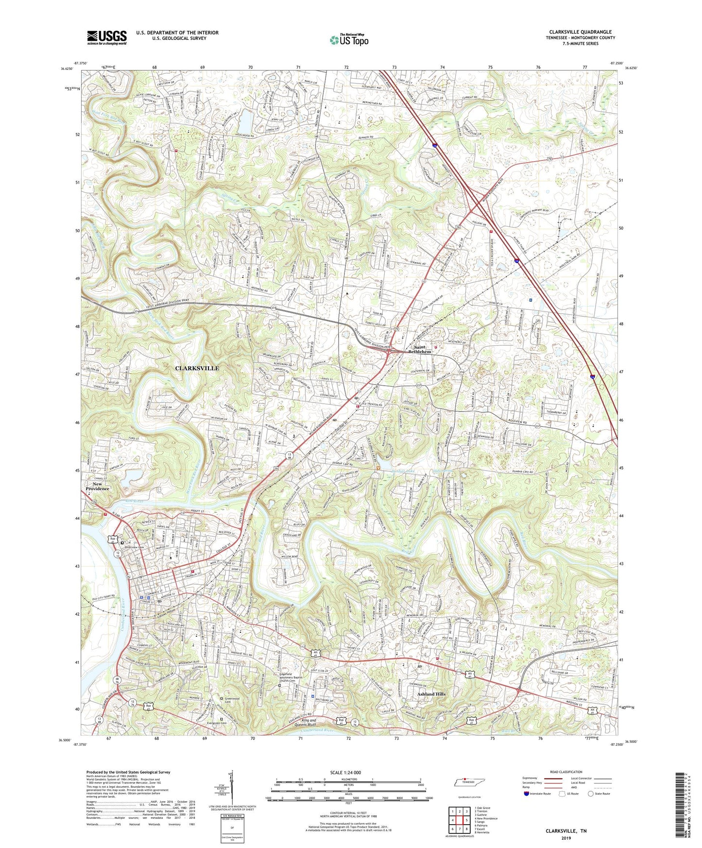
Clarksville Tennessee US Topo Map
Couldn't load pickup availability
2022 topographic map quadrangle Clarksville in the state of Tennessee. Scale: 1:24000. Based on the newly updated USGS 7.5' US Topo map series, this map is in the following counties: Montgomery. The map contains contour data, water features, and other items you are used to seeing on USGS maps, but also has updated roads and other features. This is the next generation of topographic maps. Printed on high-quality waterproof paper with UV fade-resistant inks.
Quads adjacent to this one:
West: New Providence
Northwest: Oak Grove
North: Trenton
Northeast: Guthrie
East: Sango
Southeast: Henrietta
South: Excell
Southwest: Palmyra
This map covers the same area as the classic USGS quad with code o36087e3.
Contains the following named places: Archwood, Ashland Hills, Austin Peay Recreation Area, Austin Peay State University, Balsam Estates, Barkwood, Beacon Hills, Bellamy Court, Belle Forest, Belmont, Billy Dunlop Park, Briarwood, Broomfield School, Burt School, Burt-Cobb Community Center, Cardinal Acres, Cedar Grove School, Cedarbrook, Cedarcroft, Charlestown Estates, Chesapeake Estates, City of Clarksville, Clarksville, Clarksville Academy, Clarksville City Hall, Clarksville Country Club, Clarksville Fire Rescue Department Station 1, Clarksville Fire Rescue Department Station 10, Clarksville Fire Rescue Department Station 3, Clarksville Fire Rescue Department Station 8, Clarksville Fire Rescue Department Station 9, Clarksville Foundry, Clarksville High School, Clarksville Police Department District 2, Clarksville Police Department District 3, Clarksville Post Office, Clarksville Square Shopping Center, Clarksville-Montgomery County Corporate Business Park, Clarksville-Montgomery County Historical Museum, Colonial Court, Colony Estates, Commissioner District 1, Commissioner District 13, Commissioner District 14, Commissioner District 17, Commissioner District 2, Commissioner District 20, Commissioner District 21, Commissioner District 5, Coy Lacy Park, Craigmont, Crossland Avenue Baptist Church, District 11, District 12, District 2, District 6, Dog Hill Architectural District, Downtown Architectural Historic District, Downtown Clarksville Post Office, Dunbar Cave, Dunbar Cave State Park, Dunbar Lake, Eastern Hills, Edgefield Baptist Church, Edgefield Missionary Baptist Church Cemetery, Endsville, Evergreen Cemetery, Evergreen Estates, Fairgrounds Park, Fellowship Church, Fifth Ward Baptist Church, First Baptist Church, First Christian Church, First Presbyterian Church, First United Methodist Church, Forest Hills, Forest Street United Methodist Church, Fort Bruce, Foxmoor, Gallows Hollow, Georgetown, Glen Ellen School, Governors Square Mall Shopping Center, Gracy Avenue Baptist Church, Grasslands, Green Hill Church, Greenwood Cemetery, Greenwood Middle School, Harksdale School, Hazlewood Church, Heritage Estates, Hilldale Post Office, Hillview Estates, Hillwood, Home Infirmary, Howell School, Hundred Acres, Idaho Spring, Immaculate Conception Catholic Church, Industrial Historic District, Kennedy School, King and Queens Bluff, Knollwood, Lake Barkley, Little West Fork, Madison Street Church of Christ, Madison Street United Methodist Church, Maplewood, Mason Rudolph Golf Course, McGregor Park, Meadow Lane, Memorial Hospital, Meri Court Park, Montgomery County Courthouse, Montgomery County Emergency Medical Service, Montgomery County Emergency Medical Services Station 22, Montgomery County EMS Station 28, Montgomery County Rotary Park, Montgomery County Sheriff's Office, Moore Elementary School, Mount Olive Baptist Church, Mount Olivet School, Murtland Field, Needmore Church, Needmore School, New Hope Baptist Church, Northeast High School, Northside Estates, Oakland Church, Peartree, Pettus Park, Porter Bluff Park, Red River, Richview Middle School, River Run, Rivermont, Riverview Cemetery, Roosevelt School, Rossview, Rudolphtown, Rushton, Saint Bethlehem, Saint Bethlehem Church, Saint Bethlehem Civitan Sports Complex, Saint Bethlehem Elementary School, Saint Bethlehem Post Office, Saint John Baptist Church, Seventy-Six Estates, Sevier Station, Shady Bluff, Smith Elementary School, Spring Creek Church, Spring Valley, Springs Inn Estates, St. Bethlehem Division, Swan Lake Golf Course, Swan Lake Village, Tennova Healthcare - Clarksville, Tradewinds South Shopping Center, Trinity Episcopal Church, Two Rivers Mall Shopping Center, Valley Brook Park, Valley View, Volunteer Estates, WDXN-AM (Clarksville), Wedgewood Estates, Wesley Chapel Christian Methodist Episcopal Church, West Creek, West Fork Red River, Willow Bend, Wingate, Wingate West, WJZM-AM (Clarksville), WKVL-AM (Clarksville), Woodland Estates, ZIP Code: 37040