MyTopo
Hookers Bend Tennessee US Topo Map
Couldn't load pickup availability
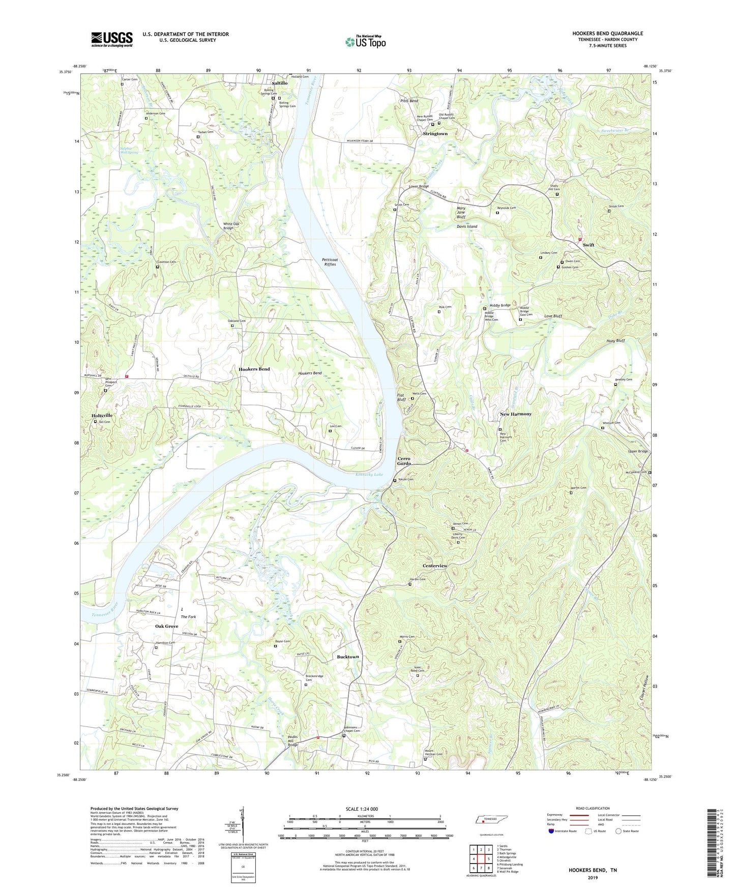
2022 topographic map quadrangle Hookers Bend in the state of Tennessee. Scale: 1:24000. Based on the newly updated USGS 7.5' US Topo map series, this map is in the following counties: Hardin. The map contains contour data, water features, and other items you are used to seeing on USGS maps, but also has updated roads and other features. This is the next generation of topographic maps. Printed on high-quality waterproof paper with UV fade-resistant inks.
Quads adjacent to this one:
West: Milledgeville
Northwest: Sardis
North: Thurman
Northeast: Bath Springs
East: Olivehill
Southeast: Wolf Pit Ridge
South: Savannah
Southwest: Pittsburg Landing
This map covers the same area as the classic USGS quad with code o35088c2.
Contains the following named places: Aenon Cemetery, Alexander Branch, Anderson Branch, Anderson Cemetery, Antioch School, Bayse Cemetery, Beasley Cemetery, Bell Branch, Berlin School, Blue Spring Branch, Boiling Springs Cemetery, Breckenridge Cemetery, Brown Corners, Bucktown, Cagle Branch, Callens Branch, Canning Factory Branch, Carter Cemetery, Cawthon Cemetery, Centerview, Cerro Gordo, Cerro Gordo Elementary School, Cerro Gordo Ferry, Cerro Gordo Landing, Clemmitt Branch, Collins Landing, Commissioner District 8, Cravens Ferry, Cravens Landing, Cypress Pond Slough, Cypress Slough, Davis Island, Davis Lagoon, Dickey Landing, District 2, Doran Slough, Duke Branch, Farmers Union Landing, Filgo Branch, Flat Bluff, Goshen Cemetery, Haislip Branch, Hamilton Cemetery, Hardin Branch, Hardin Cemetery, Hardin County Fire Department / Emergency Management District 15, Hardin County Fire Department / Emergency Management District 4 Station 1, Hardin County Fire Department / Emergency Management District 4 Station 2, Hardin County Fire Department / Emergency Management District 5, Hardin Creek Ferry, Hobbs Mill Branch, Holts Landing, Holtsville, Hookers Bend, Horse Creek, Huey Bluff, Isaac Reed Cemetery, Lee Cemetery, Liberty-Davis Cemetery, Lick Branch, Lindsey Cemetery, Love Bluff, Love Branch, Lower Bridge, Maple Slash Slough, Martin Cemetery, Mary Jane Bluff, Mays Ferry, McCasland Cemetery, Middle Bridge, Middle Bridge East Cemetery, Middle Bridge West Cemetery, Miles Creek, Miller Slough, Morris Cemetery, Mount Herman Cemetery, Mount Herman Church, New Harmony, New Harmony Baptist Church, New Harmony Cemetery, New Prospect Cemetery, New Prospect Church, New Russell Chapel Cemetery, Oak Grove, Oak Grove School, Oakland Cemetery, Oakland Church, Old Russell Chapel Cemetery, Orr Branch, Owen Cemetery, Paulks, Paulks Mill Bridge, Petticoat Riffles, Pitts Bend, Polk Cemetery, Polks Landing, Pony Creek, Reynolds Cemetery, Robinson Chapel, Robinsons Chapel Cemetery, Robinsons School, Russell Chapel, Saint Johns School, Saint Pauls Church, Saltillo Ferry, Sandford Branch, Sawmill Branch, Shady Hill Branch, Shady Hill Cemetery, Shady Hill Church, Shannons Landing, Shiloh Cemetery, Smith Cemetery, Stanfield Branch, Stringtown, Sulphur Branch, Sulphur Well, Sulphur Well Spring, Sweetwater Branch, Swift, Swift School, Tall Cemetery, Tarbet Cemetery, Thacker Branch, The Fork, Thompson Branch, Turner Branch, Union Grove Church, Union School, Upper Bridge, Walker Branch, Welch Branch, Welles Landing, Wells Cemetery, White Oak Bridge, White Oak Creek, Whitlow Branch, Whitlow Cemetery, WKWX-FM (Savannah), Yokum Cemetery