MyTopo
Savannah Tennessee US Topo Map
Couldn't load pickup availability
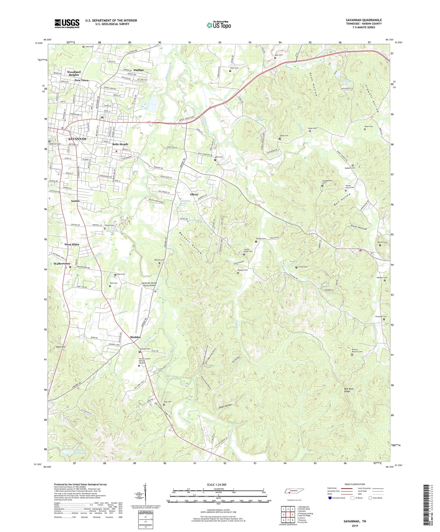
2023 topographic map quadrangle Savannah in the state of Tennessee. Scale: 1:24000. Based on the newly updated USGS 7.5' US Topo map series, this map is in the following counties: Hardin. The map contains contour data, water features, and other items you are used to seeing on USGS maps, but also has updated roads and other features. This is the next generation of topographic maps. Printed on high-quality waterproof paper with UV fade-resistant inks.
Quads adjacent to this one:
West: Pittsburg Landing
Northwest: Milledgeville
North: Hookers Bend
Northeast: Olivehill
East: Wolf Pit Ridge
Southeast: Lowryville
South: Pickwick
Southwest: Counce
This map covers the same area as the classic USGS quad with code o35088b2.
Contains the following named places: Adams Branch, Allen Hollow, Allison Branch, Austin, Bain Cemetery, Barnett Hollow, Barnhill Branch, Barnhill Church, Bee Rock Ridge, Belle Meade, Bible Methodist Church, Big Hill Cemetery, Bird Branch, Blevins Cemetery, Blount Church, Boon Cemetery, Boon Creek, Briary Branch, Bull Hollow, Burnt Church, Camp Ground Church, Campground Cemetery, Casey Cemetery, Casteal Branch, Cave Hollow, Central High School, Chimney Branch, Choate Creek, Church of God in Christ, City of Savannah, Clutch Branch, Commissioner District 1, Commissioner District 10, County Home Cemetery, Covey Branch, Covey Cemetery, Covey Chapel, DeBerry Cemetery, District 3, District 4, Dodd School, Don Coleman Dam, Don Coleman Lake, Doran Cemetery, Double Springs, Double Springs Church, Double Springs School, Dunbar High School, East End United Methodist Church, Economy, English Creek, First Assembly of God Church, First Baptist Church, First Church of God, First Cumberland Presbyterian Church, First United Methodist Church, Foursquare Church, Gant Cemetery, Graham Cemetery, Graham Chapel Christian Methodist Episcopal Church, Graham Church, Harbor Cemetery, Harbour Cemetery, Hardin County, Hardin County Farm, Hardin County Fire Department / Emergency Management District 12 Station 1 Main Station, Hardin County Fire Department / Emergency Management District 6 Station 1, Hardin County Fire Department / Emergency Management District 6 Station 2, Hardin County Fire Department / Emergency Management District 8 Station 1, Hardin County Junior High School, Hardin County Memory Gardens, Hardin County Public Library, Hardin County Vocational Center, Hardin Medical Center, Harrison Branch, Hima Branch, Holt Cemetery, Hopewell Baptist Church, Hosea Farm Cemetery, Howard Branch, Hulen Creek, Hunt School, Hurst Cemetery, Irvin Branch, Jenkins Hollow, Kadet Country Club, Kerr Branch, Kerr Spring, Little Turkey Creek, Maddox, McDonald Branch, Neill Branch, Neill Cemetery, New Town, Nixon Division, North Savannah Elementary School, Old Town, Olivet, Olivet Census Designated Place, Olivet Church, Oxen Hollow, Paulk Spring, Perkins Branch, Perkins-McCurry Cemetery, Phillips, Pickens Cemetery, Pleasant Grove Church, Plummer Cemetery, Plummer Church, Robertson Branch, Robinson Branch, Ross Branch, Ross Cemetery I, Ross Cemetery II, Sand Hill, Sand Hill Church, Savannah, Savannah Cemetery, Savannah Church of Christ, Savannah Country Club, Savannah Division, Savannah Fire Department, Savannah Heights Church of Christ, Savannah Historic District, Savannah Seventh Day Adventist Church, Savannah-Hardin County Airport, Scott Branch, Second Baptist Church, Sevier Chapel School, Smith Cemetery, South Elementary School, Southside Baptist Church, Spencer Branch, Steele Creek, Sugar Camp Hollow, Tidwell Hollow, Timberline Estates Dam, Timberline Estates Lake, Todd Branch, Trinity Church, Turkey Creek, Turkey Creek Church, Union Church, Walker Elementary School, Walkertown, West Hima, White School, Whitlow Branch, Willoughby School, Willoughby Spring, Woodland Heights, WORM-AM (Savannah), WORM-FM (Savannah), ZIP Code: 38372