MyTopo
Pittsburg Landing Tennessee US Topo Map
Couldn't load pickup availability
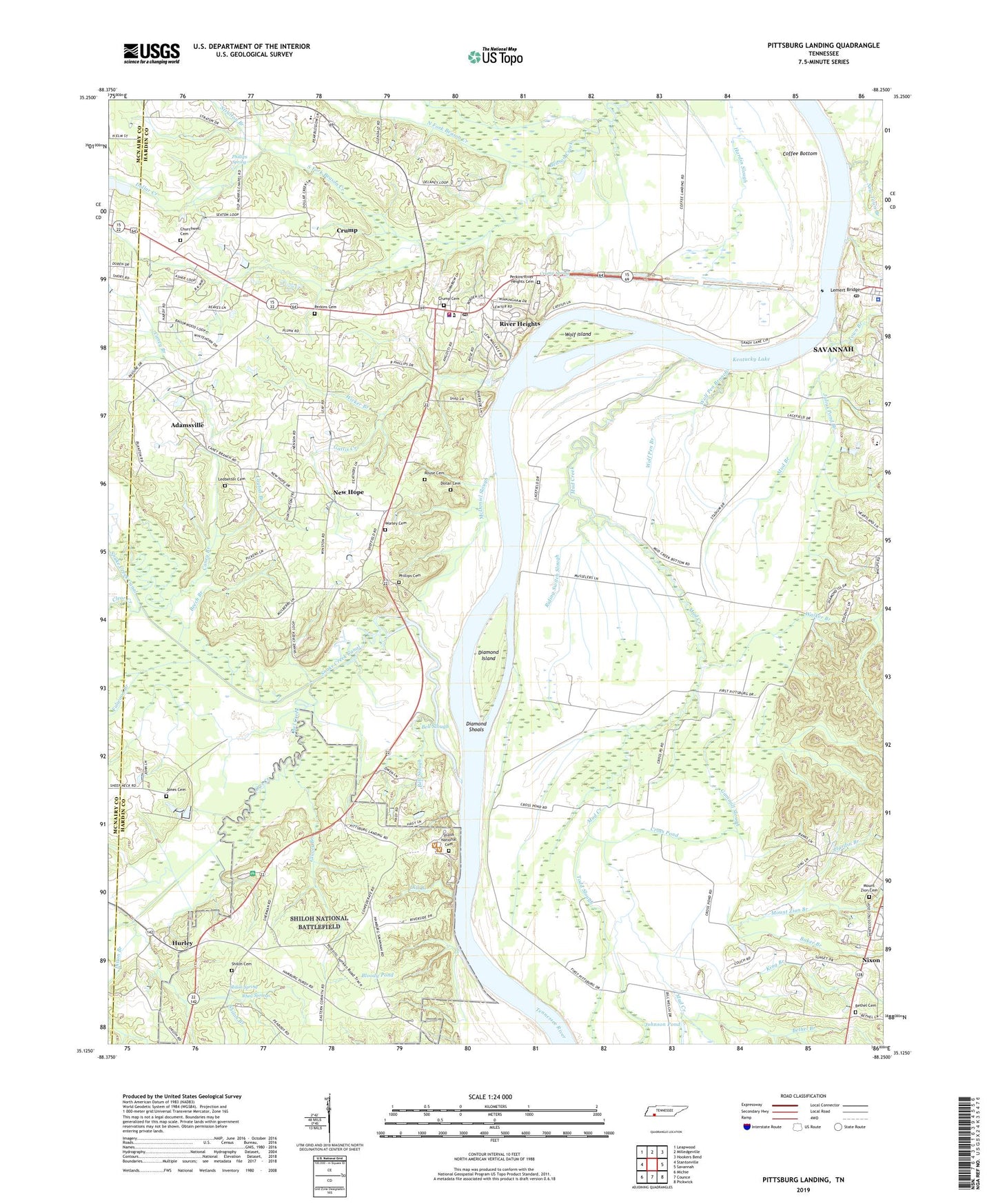
2022 topographic map quadrangle Pittsburg Landing in the state of Tennessee. Scale: 1:24000. Based on the newly updated USGS 7.5' US Topo map series, this map is in the following counties: Hardin, McNairy. The map contains contour data, water features, and other items you are used to seeing on USGS maps, but also has updated roads and other features. This is the next generation of topographic maps. Printed on high-quality waterproof paper with UV fade-resistant inks.
Quads adjacent to this one:
West: Stantonville
Northwest: Leapwood
North: Milledgeville
Northeast: Hookers Bend
East: Savannah
Southeast: Pickwick
South: Counce
Southwest: Michie
This map covers the same area as the classic USGS quad with code o35088b3.
Contains the following named places: Adamsville Recreation Area, Baker Branch, Ballard School, Beech Branch, Bell Slough, Bethel Branch, Bethel Cemetery, Bethel Church, Bloody Pond, Browns Ferry, Buells Landing, Caney Branch, Churchwell Cemetery, City of Crump, Clear Creek, Coffee Bottom, Commissioner District 4, Commissioner District 9, Cross Pond, Crump, Crump Cemetery, Crump Landing, Crump Police Department, Crump Post Office, Crump School, Crump Spring, Crump United Methodist Church, Diamond Island, Diamond Shoals, Dill Branch, Dillon Branch, District 11, District 15, Dollar Cemetery, Dollar Creek, First Pentecostal Church, Fulwood Branch, Gammill Slough, Gattis Creek, Glover Branch, Hagy Bridge, Hardin Branch, Hardin County Courthouse, Hardin County Fire Department / Emergency Management District 2 South Station, Hardin County Sheriff's Office, Hornets Nest, Hurley, Johnson Pond, Jones Cemetery, Julius Pond Branch, King Branch, Layton Branch, Ledbetter Cemetery, Lemert Bridge, McDaniel Slough, Mount Zion Branch, Mount Zion Cemetery, Mount Zion Church of God, Mud Branch, Mud Creek, New Hope, New Hope School, New Salem School, New Town Branch, North Fork Beason Creek, Novels Old Mill, Owl Creek, Perkins Bluff Landing, Perkins Cemetery, Perkins-River Heights Cemetery, Phillips Cemetery, Phillips Spring, Pittsburg Landing, Pittsburg Landing Ferry, Rhea Springs, Riding Switch Slough, River Heights, Riverside City Park, Rouse Cemetery, Savannah Ferry, Savannah Post Office, Shiloh Branch, Shiloh Cemetery, Shiloh Church, Shiloh National Battlefield, Shiloh National Cemetery, Shiloh School, Shiloh Spring, Snake Creek, Snake Creek Canal, South Fork Beason Creek, Stratton Branch, Todd Slough, Town Branch, Walker Branch, Walkers Landing, Water Oaks Pond, West Hardin Elementary School, Wicker Branch, Williams Slough, WLIC-AM (Adamsville), Wolf Island, Wolf Pen Branch, Worley Cemetery, ZIP Code: 38327