MyTopo
Hustburg Tennessee US Topo Map
Couldn't load pickup availability
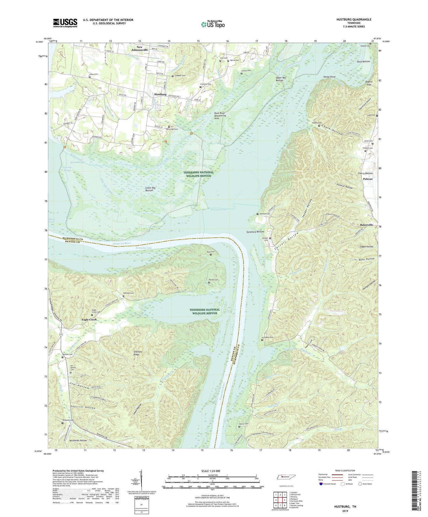
2022 topographic map quadrangle Hustburg in the state of Tennessee. Scale: 1:24000. Based on the newly updated USGS 7.5' US Topo map series, this map is in the following counties: Humphreys, Benton. The map contains contour data, water features, and other items you are used to seeing on USGS maps, but also has updated roads and other features. This is the next generation of topographic maps. Printed on high-quality waterproof paper with UV fade-resistant inks.
Quads adjacent to this one:
West: Rockport
Northwest: Camden
North: Johnsonville
Northeast: Waverly
East: Hurricane Mills
Southeast: Lobelville
South: Daniels Landing
Southwest: Sugar Tree
This map covers the same area as the classic USGS quad with code o35087h8.
Contains the following named places: Arrington Cemetery, Bakerville School, Beason Branch, Blue Creek, Briar Creek, Broad Slough, Buchanans Landing, Burnett Branch, Byrd Cemetery, Byrd School, Byrds Landing, Carroll Hollow, Chalk Hollow, Chappell Cemetery, Chappell Hollow Branch, Clear Branch, Clear Lake, Clear Lake Drain, Clear Spring, Clear Spring School, Cow Gap Landing, Crab Place, Craig Hollow, Crockett Cemetery, Cuba Hollow, Cuba Landing, Cude Cemetery, Cypress Pond, DePriest Cemetery, Dixie Landing, Dreden Cemetery, Dry Branch, Dry Branch Cemetery, Dry Branch Church, Dry Branch School, Duck Bottom, Duck River, Duck River Dewatering Area, Duck River Unit Tennessee National Wildlife Refuge, Dughill, Dughill Gap, Duncan Branch, Eagle Creek, Eagle Creek Baptist Church, Eagle Creek Cemetery, Ebenezer Church, Estes Cemetery, Foote Mineral Company Dam Number One, Foote Mineral Company Tailings Pond, Fowlkes Cemetery, Fry Hollow, Grassy Lake Drain, Haggard Branch, Hamm Cemetery, Harmon Creek, High Bank Landing, Honey Point, Hustburg, Hustburg Creek, Jones Cemetery, Larkins Cemetery, Lawrence Creek, Lees Point Landing, Lewis Hollow, Liberty Church, Link Cemetery, Lower Big Bottom, Matlock Cemetery, McCallie Landing, Morris Cemetery, Neblett Cemetery, Oak Grove Church, Old Cathole, Opossum Creek, Overcup Slough, Pavatt Cemetery, Pavatt Landing, Pavatt School, Polecat, Polecat Hollow, Pond Creek, Roberts Creek, Rock College School, Rockport Island, Simmons Branch, Simmons Branch Industrial Site, Sinkhole Ridge, Squirrel Hollow, Stribling Branch, Swader Hollow, Sycamore Bottom, Sycamore Landing, Tanyard Branch, Tennessee National Wildlife Refuge, Tribble High School, Turner Landing, Upper Big Bottom, Vanhook Cemetery, Varbrough Cemetery, Walker Cemetery, West Cuba Landing, West Dixie Landing, West Sycamore Landing, Willbanks Cemetery, Willbanks Hollow, ZIP Code: 37134