MyTopo
Lexington Tennessee US Topo Map
Couldn't load pickup availability
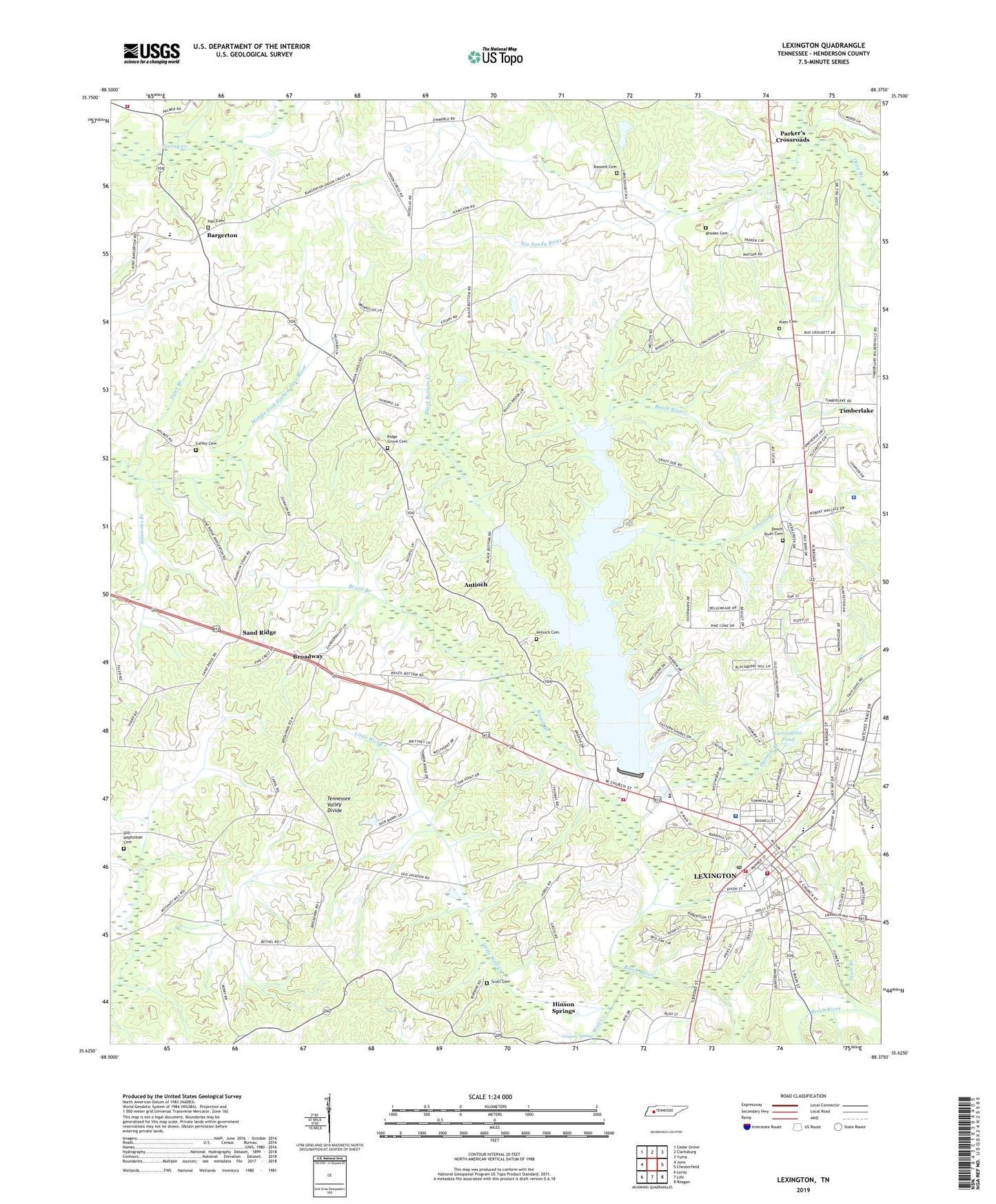
2022 topographic map quadrangle Lexington in the state of Tennessee. Scale: 1:24000. Based on the newly updated USGS 7.5' US Topo map series, this map is in the following counties: Henderson. The map contains contour data, water features, and other items you are used to seeing on USGS maps, but also has updated roads and other features. This is the next generation of topographic maps. Printed on high-quality waterproof paper with UV fade-resistant inks.
Quads adjacent to this one:
West: Juno
Northwest: Cedar Grove
North: Clarksburg
Northeast: Yuma
East: Chesterfield
Southeast: Reagan
South: Life
Southwest: Luray
This map covers the same area as the classic USGS quad with code o35088f4.
Contains the following named places: Antioch, Antioch Cemetery, Antioch Primitive Baptist Church, Antioch School, Bargerton, Bargerton Church of Christ, Bargerton Elementary School, Bargerton Post Office, Beech Dam, Beech Lake, Beech River, Beech River Cemetery, Beech River Church, Beech River School, Beechlake Shopping Center, Berry Lake, Berry Lake Dam, Bethel Church, Black Bottom Creek, Bolens Chapel, Boswell Cemetery, Brazil Branch, Broad Street Church of Christ, Broadway, Caffey Cemetery, Carrington Pond, Carter Ridge School, Caywood Elementary School, Center Ridge Church, Commissioner District 6, Cooper Grove School, Eastgate Shopping Center, Everett Horn Library, Fairview Church, First United Methodist Church, Franklin Wilkins Airport, Graper Spring, Graves Branch, Hall Cemetery, Henderson County, Henderson County Ambulance Service, Henderson County Community Hospital, Henderson County Courthouse, Henderson County Fire Department Station 2, Henderson County Fire Department Station 7, Henderson County Rescue Squad, Henderson County Sheriff's Offfice, Henderson County Vocational Center, Hinson Springs, Keys Chapel United Methodist Church, Kizer Cemetery, Kizer School, Lewis Chapel African Methodist Episcopal Church, Lexington, Lexington City Hall, Lexington Division, Lexington Fire Department Station 1 Headquarters, Lexington Fire Department Station 2, Lexington High School, Lexington Landfill, Lexington Police Department, Lexington Post Office, Lexington Sewage Lagoon Dam, Lexington Sewage Lagoon Pond, Little Wolf Creek, McCaneys Mill, Milam Dam, Milam Pond, Montgomery School, Old Hephzibah Cemetery, Olive Branch, Onemile Branch, Pine Grove Church, Prospect Church, Rhodes Cemetery, Ridge Grove Cemetery, Ridge Grove Church, Rogers Store, Ruby Grove School, Sand Ridge, Sand Ridge Baptist Church, Sand Ridge School, Scott Cemetery, Simmons Branch, Timberlake, Timberlake School, Town Branch, Tyler Branch, WDXL-AM (Lexington), Wolf Creek, WZLT-FM (Lexington), Zion Rest Church, ZIP Code: 38351