MyTopo
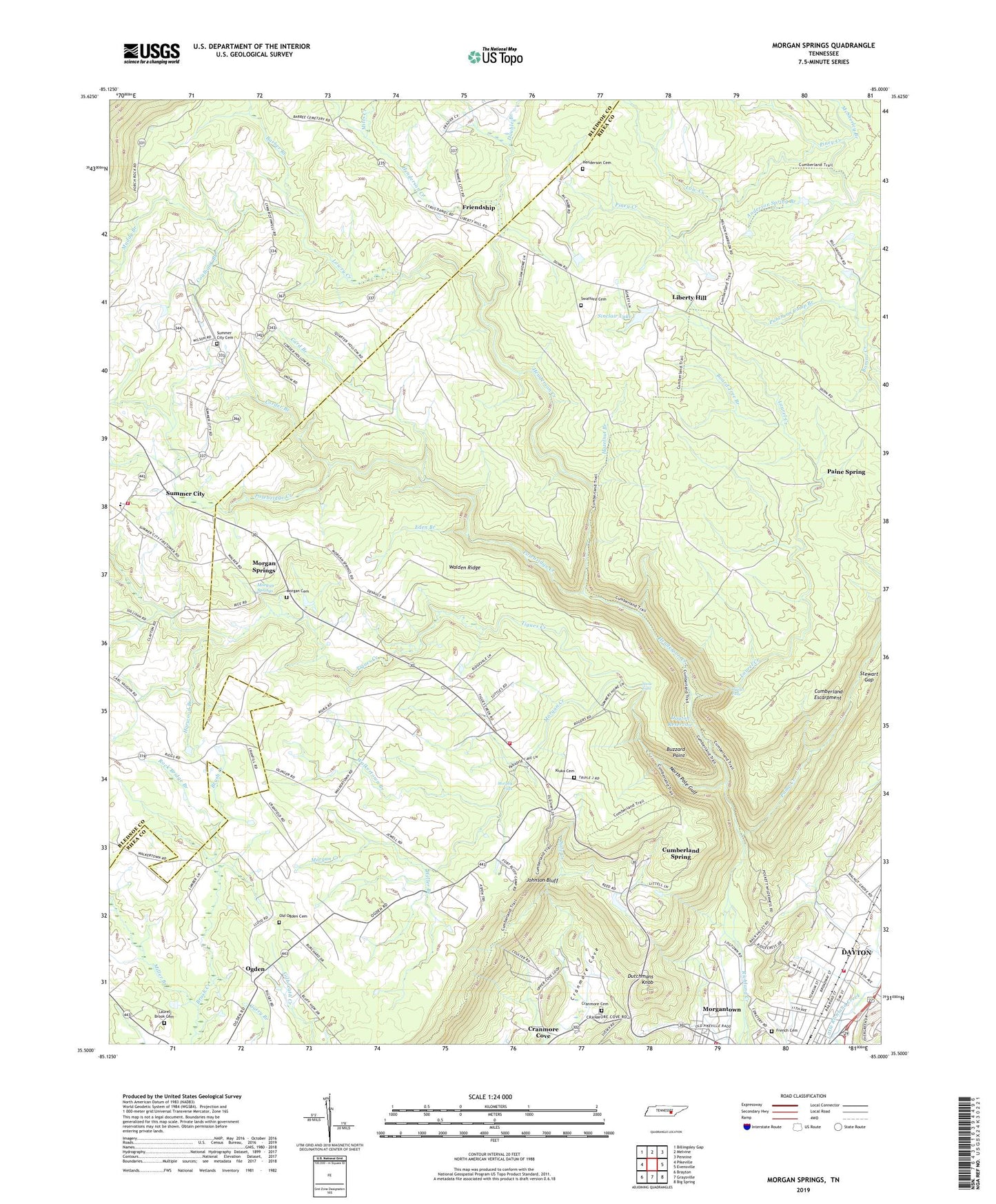
Morgan Springs Tennessee US Topo Map
Couldn't load pickup availability
2022 topographic map quadrangle Morgan Springs in the state of Tennessee. Scale: 1:24000. Based on the newly updated USGS 7.5' US Topo map series, this map is in the following counties: Rhea, Bledsoe. The map contains contour data, water features, and other items you are used to seeing on USGS maps, but also has updated roads and other features. This is the next generation of topographic maps. Printed on high-quality waterproof paper with UV fade-resistant inks.
Quads adjacent to this one:
West: Pikeville
Northwest: Billingsley Gap
North: Melvine
Northeast: Pennine
East: Evensville
Southeast: Big Spring
South: Graysville
Southwest: Brayton
This map covers the same area as the classic USGS quad with code o35085e1.
Contains the following named places: Anderson Spring Branch, Barber Branch, Bethel Church, Board Tree Branch, Buzzard Point, Card Branch, Cecil B Rigsby Elementary School, Coalbank Branch, Commissioner District 5, Commissioner District 9, Corder Branch, Cove Chapel, Cranmore Cemetery, Cranmore Cove, Cranmore Cove Baptist Church, Cranmore School, Cumberland Mine, Cumberland Spring, Dayton Division, Dayton Reservoir, Dixon Slope Mine, Double Branch, Dutchmans Knob, Eden Branch, French Cemetery, Friendship, Friendship Church, Harwood Branch, Hazelnut Branch, Henderson Cemetery, Henderson Creek, Henderson Mill, Johnson Bluff, Kiuka Cemetery, Kiuka School, Laurel Brook Cemetery, Laurel Creek, Laurel Falls, Laurel-Snow Trail, Liberty Hill, Liberty Hill School, Little Richland Creek, Low Creek, Lower Falls Mine, Lowry Creek, McSherley Branch, Miller Branch, Mitts Creek, Morgan Cemetery, Morgan Creek, Morgan Mine, Morgan Springs, Morgantown, Morgantown School, Morphy Falls, Muddy Branch, Nelson Mine, New Prospect Mine, North Dayton, North Pole Gulf, Northtown Plaza Shopping Center, Ogden, Ogden Church, Old Ogden Cemetery, Paine Creek, Paine Spring, Polebridge Creek, Puncheon Camp Branch, Rhea County Fire Department Station 2 765 Kiuka Fire District, Rhea County Fire Department Station 600, Rhea County Fire Department Station 765, Richland Mine, Rigsby Volunteer Fire Department, Rock Bridge Branch, Sinclair Lake, Sinclair Lake Dam, Skyline Bible Ranch, Snow Falls, Stewart Gap, Stewart Gap Mine, Summer City, Summer City Baptist Church, Summer City Cemetery, Summer City Church of God, Summer City School, Swafford Cemetery, Tigues Creek, Upper Falls Mine, Vine Grove Methodist Church, Walden Ridge, Walden Ridge Church, Waldens Ridge Church, Waldens Ridge Elementary School, Walkertown Branch, Weller Branch, Williamson Mine, WKoe-AM (Dayton), ZIP Code: 37321