MyTopo
Pickwick Tennessee US Topo Map
Couldn't load pickup availability
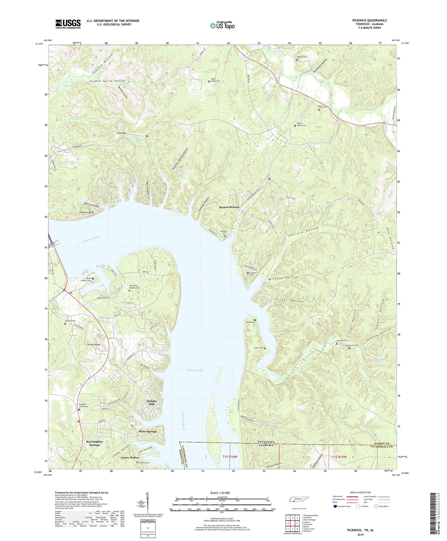
2022 topographic map quadrangle Pickwick in the state of Tennessee. Scale: 1:24000. Based on the newly updated USGS 7.5' US Topo map series, this map is in the following counties: Hardin, Lauderdale. The map contains contour data, water features, and other items you are used to seeing on USGS maps, but also has updated roads and other features. This is the next generation of topographic maps. Printed on high-quality waterproof paper with UV fade-resistant inks.
Quads adjacent to this one:
West: Counce
Northwest: Pittsburg Landing
North: Savannah
Northeast: Wolf Pit Ridge
East: Lowryville
Southeast: Waterloo
South: Yellow Creek
Southwest: Doskie
This map covers the same area as the classic USGS quad with code o35088a2.
Contains the following named places: Adams Ferry, Arch Branch, Austin Hollow, Bennett Hollow, Bevins Branch, Blackburn Branch, Blowing Spring, Blowing Spring Hollow, Bluff Creek, Boyds Landing, Boyer Branch, Branum Cemetery, Bruton Branch, Bruton School, Bryson Branch, Bryson School, Buck Branch, Burnt Stand Cemetery, Burnt Stand Church, Burton Branch State Recreation Area, Caney Hollow, Chimney Hollow, Civilian Conservation Corps Camp Number 3459, Clear Branch, Cold Spring Branch, Commissioner District 2, Covey Branch, District 8, District 9, Dry Creek, Dry Creek School, Duncans Landing, Factory Hollow, Fisher Hollow, Fraleys Landing, Franks Hollow, Garrett Cemetery, Gibbs, Hardin Company Dock, Hardin County Fire Department / Emergency Management District 14 Station 1, Hardin County Fire Department / Emergency Management District 3 Station 3, Hardin County Fire Department / Emergency Management District 7 Station 2, Haw Branch, Higgins Landing, Hitchcock Cemetery, Holiday Hills, Holland Creek, Hollow Field Branch, Lower Anderson Branch, Mangrans Landing, McKelvey Hollow, Mill Creek, Mill Hollow, Morris Cemetery, Mount Tabor Cemetery, Mount Tabor Church, Mount Tabor Spring, New Chapel, Old White Sulphur Cemetery, Pickens Branch, Pickwick Dam, Pickwick Dam Post Office, Pickwick Landing, Pickwick Landing State Park, Pickwick United Methodist Church, Pickwick White Sulphur Cemetery, Pompeys Branch, Pompeys Branch Estates, Porter Branch, Porter School, Pyburn Bluff, Pyburns Bluff Ferry, Pyburns Bluff Landing, Quarry Hollow, Rainbow Falls, Red Sulphur Springs, Rockhouse Hollow, Rocky Branch, Ross Cemetery, Sand Mountain, Shanghai Cemetery Number 1, Short Hollow, Slate Rock Creek, Spout Spring, Stewart Hollow, Stout Cemetery, Sulfur Spring, Sulphur Creek, Sulphur Spring Hollow, Tacker Cemetery, Tanyard Hollow, Thomas Cemetery, Turkey Knob, Upper Anderson Branch, Walnut Grove, Walnut Grove Church, Walnut Grove School, White Sulphur, White Sulphur Methodist Church, White Sulphur School, Whites Landing, Wildcat Hollow, Winn Landing, Winn Springs, Winn Springs Branch, Wood Cemetery, ZIP Code: 38365