MyTopo
Counce Tennessee US Topo Map
Couldn't load pickup availability
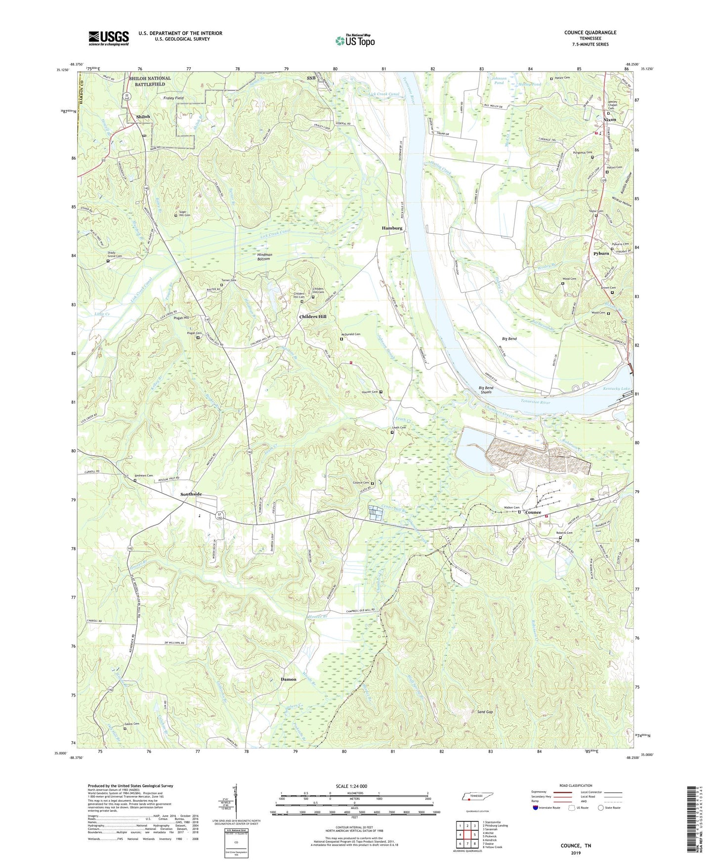
2022 topographic map quadrangle Counce in the state of Tennessee. Scale: 1:24000. Based on the newly updated USGS 7.5' US Topo map series, this map is in the following counties: Hardin, McNairy. The map contains contour data, water features, and other items you are used to seeing on USGS maps, but also has updated roads and other features. This is the next generation of topographic maps. Printed on high-quality waterproof paper with UV fade-resistant inks.
Quads adjacent to this one:
West: Michie
Northwest: Stantonville
North: Pittsburg Landing
Northeast: Savannah
East: Pickwick
Southeast: Yellow Creek
South: Doskie
Southwest: Kendrick
This map covers the same area as the classic USGS quad with code o35088a3.
Contains the following named places: Austin Hollow, Barbwood Branch, Barnes Branch, Batey Branch, Battles Branch, Bellis Dock, Beshears Cemetery, Bethel Church, Bethel School, Big Bend, Big Bend Shoals, Blevins Branch, Bluff Spring Branch, Booker Branch, Browder Branch, Brown Cemetery, Callens Dock, Callens Ferry, Center Hill Branch, Center Hill Church, Chambers Creek, Charles Wood Cemetery, Childers Hill, Childers Hill Cemetery, Childers Hill Census Designated Place, Childers Hill School, Churchwell Landing, Commissioner District 3, Counce, Counce Cemetery, Counce Census Designated Place, Counce Post Office, Damon, District 10, District 6, Emmanuel Church, Fraley Field, Griscoms Landing, Hamburg, Hamburg Ferry, Hamburg Landing, Hardin County Fire Department / Emergency Management District 3 Station 1, Hardin County Fire Department / Emergency Management District 3 Station 2, Hardin County Fire Department / Emergency Management District 7 Station 1, Hatley Cemetery, Hatley Cemetery 2, Hatley Creek, Hatley Pond, Hindman Bottom, Hindman Branch, Hoover Branch, Hoover Cemetery, Houston Branch, Johnson Slough, Kelley Branch, Leath Cemetery, Leath Creek, Lick Creek, Lick Creek Canal, Little Creek, Littlejohn Branch, McDonald Cemetery, Murdock Branch, Nash Landing, Nixon, Nixon Census Designated Place, Nixon Elementary School, North Carolina Landing, Pickwick Church, Pickwick Division, Pickwick Ferry, Pickwick Landing Dam, Pine Ridge School, Pisgah Branch, Pisgah Church, Pisgah Hill, Pisgah Methodist Church Cemetery, Purgamus Cemetery, Pyburn, Pyburn Church Cemetery, Roberts Cemetery, Robinson Creek, Salem Cemetery, Sand Gap, Shady Grove Cemetery, Shiloh, Shiloh Census Designated Place, Shiloh Post Office, Slab Town, South Side School, Southside, Spain Branch, Sugar Hill Cemetery, Taylor Cemetery, Tennessee River Pulp and Paper Company East Dam, Tennessee River Pulp and Paper Company West Dam, Tennessee River Pulp and Paper East Lake, Tennessee River Pulp and Paper West Lake, Tucker Landing, Turner Branch, Turner Cemetery, Union Grove Church, Walker Cemetery, Watkins Branch, Wayne School, Wesley Chapel, Wesleys Chapel Cemetery, Wildcat Hollow, William Wood Cemetery, Woods Branch, Worley Branch, ZIP Codes: 38326, 38376