MyTopo
Missouri City Texas US Topo Map
Couldn't load pickup availability
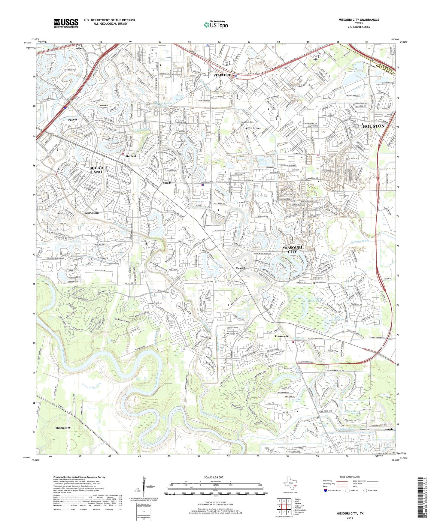
2022 topographic map quadrangle Missouri City in the state of Texas. Scale: 1:24000. Based on the newly updated USGS 7.5' US Topo map series, this map is in the following counties: Fort Bend, Harris. The map contains contour data, water features, and other items you are used to seeing on USGS maps, but also has updated roads and other features. This is the next generation of topographic maps. Printed on high-quality waterproof paper with UV fade-resistant inks.
Quads adjacent to this one:
West: Sugar Land
Northwest: Clodine
North: Alief
Northeast: Bellaire
East: Almeda
Southeast: Juliff
South: Thompsons
Southwest: Smithers Lake
This map covers the same area as the classic USGS quad with code o29095e5.
Contains the following named places: A W Emergency Medical Service, Abiding Faith Baptist Church, Aerodrome - Sugar Land, Alcorn Bayou, Alkire Lake, All Saints Episcopal Church, Austin Parkway Elementary School, Austin Parkway Shopping Center, Bethel Baptist Church, Black Lake, Browns Bayou, Bullhead Bayou, Cementerio San Isidro, Chasewood, Christ United Methodist Church, Christian Bible Baptist Church, Church of Christ Murphy Road, City of Missouri City, Colony Baptist Church, Colony Bend Elementary School, Commonwealth Elementary School, Community Fellowship Baptist Church, Community Hospital Heliport, Covenant Glen United Methodist Church, Dewalt, Dewalt Cemetery, Dove Country Shopping Center, Dulles Elementary School, Dulles High School, Dulles High School Practice Stadium, Dulles Middle School, E A Jones Elementary School, East Wind Missionary Baptist Church, Ebenezer Church, Edgar Glover Junior Elementary School, Edward Mercer Stadium, Eldridge Lake, Elkins High School Baseball Field, Elkins High School Football Field and Track, Elkins High School Softball Field, Fifth Street, Fifth Street Census Designated Place, Fire Station Number 3, Fire Station Number 4, First Baptist Church, First Baptist Church of Missouri City, First Colony, First Colony Bible Chapel Church, First Colony Church of Christ Youth Ministry, First Colony Commons Shopping Center, First Colony Middle School, First Colony Post Office, First Colony Shopping Center, Flat Bank Creek, Fluor Daniel Incorporated Heliport, Fort Bend Church of God in Christ, Fort Bend County Constable's Office Precinct 2, Fort Bend County Library, Fort Bend Independent School District Baseball Field, Fort Bend Independent School District Police Department, Fort Bend Medical Center, Fort Bend WCID 1 Oyster Creek Dam 3, Frost Lake, Grace Community Church, Great Oaks Baptist Church, Herbert, Hermann Hospital Lake, Highlands Elementary School, Holy Family Church, Horseshoe Alkire and Eldridge Lake, Horseshoe Lake, Houston Fishing Club Lake, Hunters Glen, Hunters Glen Elementary School, Jehovahs Witnesses Church, Jones School, Kaneb Heliport, KETH-TV (Houston), KFMK-FM (Houston), KHMX-FM (Houston), KHOU-TV (Houston), KIKK-FM (Houston), KILT-FM (Houston), Kingsway, Kitty Hollow Lake, Kitty Hollow Lake Dam, KKBQ-FM (Pasadena), KLDE-FM (Houston), KLOL-FM (Houston), KNWS-TV (Katy), KODA-FM (Houston), KRBE-FM (Houston), KTXH-TV (Houston), KXLN-TV (Rosenberg), Lake Olympia Middle School, Lantern Lane Elementary School, Lawrence E Elkins High School, Lexington Creek Elementary School, Market at First Colony Shopping Center, Market at Town Center, Missouri City, Missouri City Annex Post Office, Missouri City Baptist Church, Missouri City City Hall, Missouri City Fire And Rescue Services Station 1, Missouri City Fire And Rescue Services Station 3, Missouri City Fire and Rescue Services Station 4, Missouri City Fire Department, Missouri City Middle School, Missouri City Police Department, Missouri City Post Office, Mount Olive Church, Mount Pleasant Church, New Hope Baptist Church, New Hope Cemetery, Old River, Oxford, Oyster Creek Trail, Palmer Elementary School, Paynes, Primera Iglesia Bautista Church, Progressive High School, Providence Presbyterian Church, Quail Creek Center Shopping Center, Quail Glen, Quail Ridge Plaza Shopping Center, Quail Valley, Quail Valley Baptist Church, Quail Valley Community Church, Quail Valley East, Quail Valley Elementary School, Quail Valley Middle School, Rapid Medical Response Ambulance, Riverbend Country Club, Saint Catherine of Siena Episcopal Church, Saint John Church, Saint Joseph Syro Malabar Catholic Church, Saint Jude Shrine Roman Catholic Chapel, Settlers Way Elementary School, Sienna Crossing Elementary School, Sienna Valley Community Church, Smada, Snake Slough, Southminster Presbyterian Church, Stafford, Stafford Fire Department Station Number 1, Stafford High School, Stafford Middle School, Stafford Police Department, Stafford Run, Stafford-Missouri City Division, Steep Bank Creek, Sugar Creek Baptist Church, Sugar Land Fire Department Station 3, Sugar Land Fire Department Station 4, System Canal, Thunderbird West, Trammels, Trinity Baptist Church, Venetian Lake, West Side Baptist Church, Williams Trace Shopping Center, Willowisp Country Club, Willowridge Baptist Church, YMCA, ZIP Codes: 77459, 77477, 77478, 77489