MyTopo
Hillsboro East Texas US Topo Map
Couldn't load pickup availability
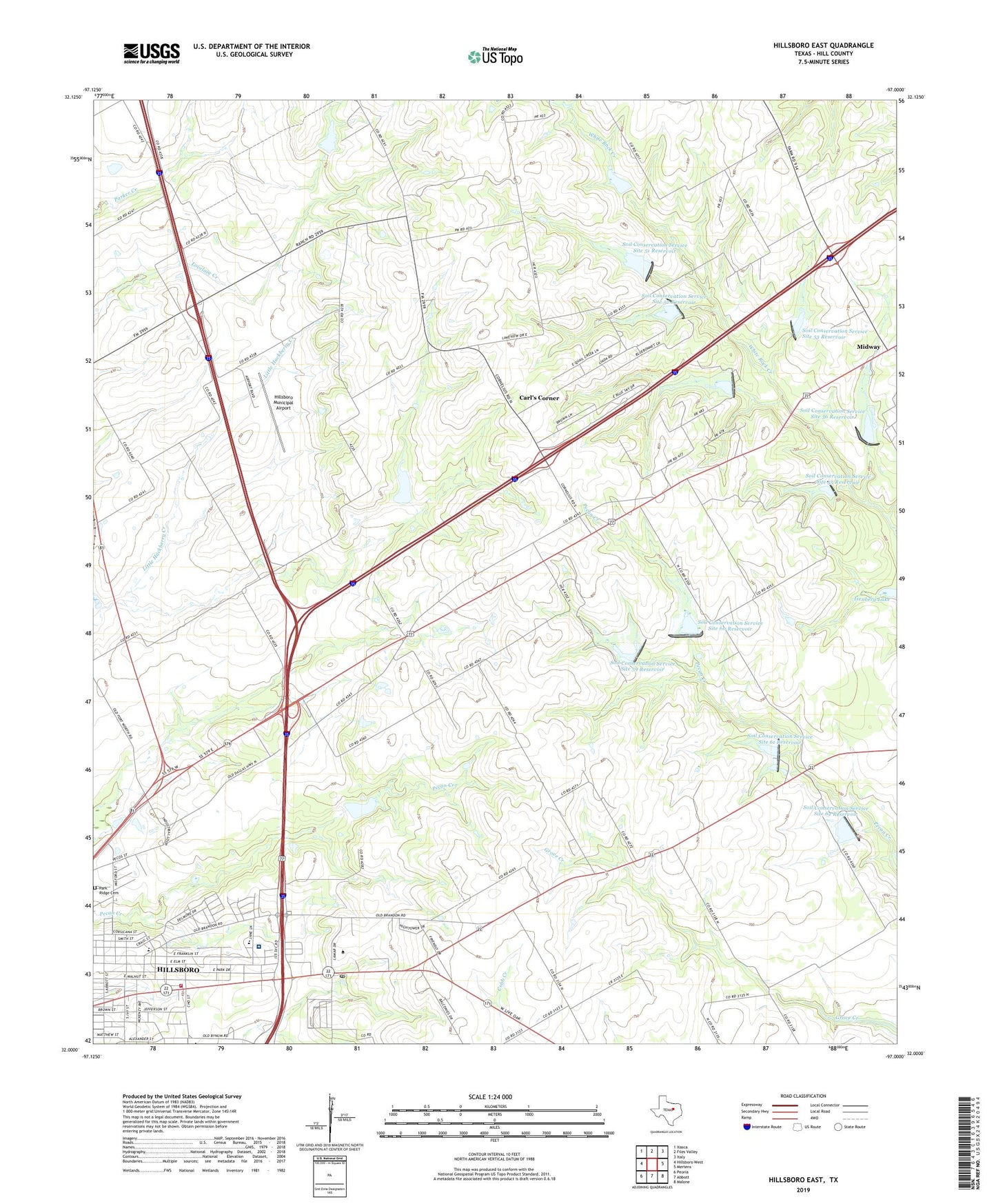
2022 topographic map quadrangle Hillsboro East in the state of Texas. Scale: 1:24000. Based on the newly updated USGS 7.5' US Topo map series, this map is in the following counties: Hill. The map contains contour data, water features, and other items you are used to seeing on USGS maps, but also has updated roads and other features. This is the next generation of topographic maps. Printed on high-quality waterproof paper with UV fade-resistant inks.
Quads adjacent to this one:
West: Hillsboro West
Northwest: Itasca
North: Files Valley
Northeast: Italy
East: Mertens
Southeast: Malone
South: Abbott
Southwest: Peoria
This map covers the same area as the classic USGS quad with code o32097a1.
Contains the following named places: Carls Corner, Christ Lutheran Church, City of Hillsboro, Dam Number 51, Dam Number 52, Dam Number 53, Dam Number 54, Dam Number 55, Dam Number 56, Dam Number 59, Dam Number 60, Dam Number 61, Dam Number 62, Emmanuel Temple Church of God in Christ, First Presbyterian Church, Franklin Elementary School, Franklin School, Grimes House, Hill College, Hill Junior College, Hill Regional Hospital, Hillsboro City Park, Hillsboro Elementary School, Hillsboro Fire Station 2, Hillsboro Municipal Airport, Isenberg Lake, Isenberg Lake Dam, KHBR-AM (Hillsboro), Lakenon, Life Care Plus Emergency Medical Services, Love View Church, Macedonia Baptist Church, Midway, Mount Zion Lutheran Church, Mountain View, Park Ridge Cemetery, Peabody School, Prime Outlets at Hillsboro, Saint Marys Episcopal Church, Soil Conservation Service Site 17 Dam, Soil Conservation Service Site 17 Reservoir, Soil Conservation Service Site 50 Dam, Soil Conservation Service Site 50 Reservoir, Soil Conservation Service Site 51 Dam, Soil Conservation Service Site 51 Reservoir, Soil Conservation Service Site 52 Dam, Soil Conservation Service Site 52 Reservoir, Soil Conservation Service Site 53 Dam, Soil Conservation Service Site 53 Reservoir, Soil Conservation Service Site 54 Dam, Soil Conservation Service Site 54 Reservoir, Soil Conservation Service Site 55 Dam, Soil Conservation Service Site 55 Reservoir, Soil Conservation Service Site 56 Dam, Soil Conservation Service Site 56 Reservoir, Soil Conservation Service Site 59 Dam, Soil Conservation Service Site 59 Reservoir, Soil Conservation Service Site 60 Dam, Soil Conservation Service Site 60 Reservoir, Soil Conservation Service Site 61 Dam, Soil Conservation Service Site 61 Reservoir, Soil Conservation Service Site 62 Dam, Soil Conservation Service Site 62 Reservoir, The Harold B Simpson Confederate Research Center, Town of Carl's Corner, Travis School