MyTopo
Mansfield Dam Texas US Topo Map
Couldn't load pickup availability
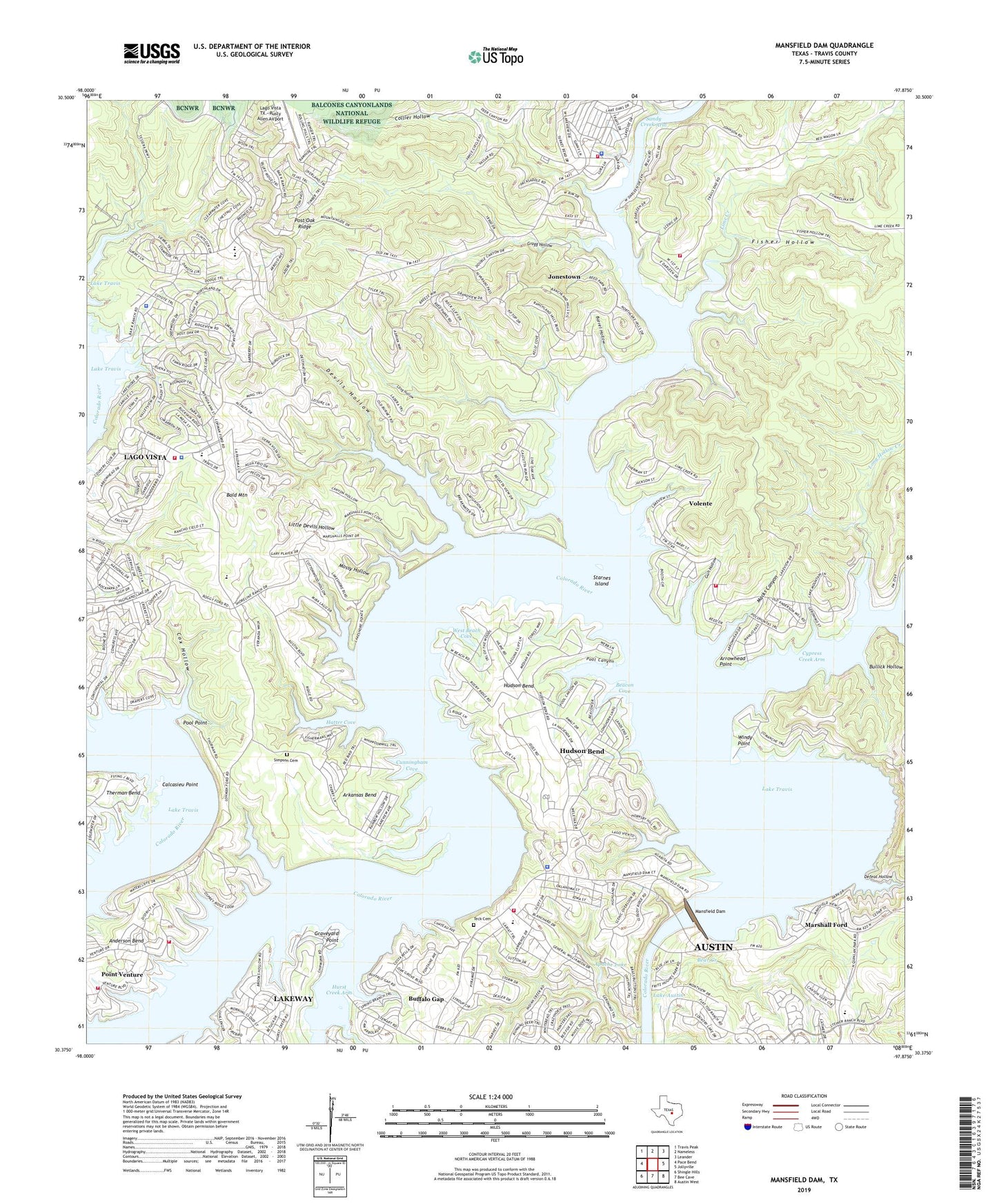
2022 topographic map quadrangle Mansfield Dam in the state of Texas. Scale: 1:24000. Based on the newly updated USGS 7.5' US Topo map series, this map is in the following counties: Travis. The map contains contour data, water features, and other items you are used to seeing on USGS maps, but also has updated roads and other features. This is the next generation of topographic maps. Printed on high-quality waterproof paper with UV fade-resistant inks.
Quads adjacent to this one:
West: Pace Bend
Northwest: Travis Peak
North: Nameless
Northeast: Leander
East: Jollyville
Southeast: Austin West
South: Bee Cave
Southwest: Shingle Hills
This map covers the same area as the classic USGS quad with code o30097d8.
Contains the following named places: Anderson Bend, Apache Lake, Apache Lake Dam, Arkansas Bend, Arkansas Bend Park, Arkansas Bend Trail, Arrowhead Point, Austin / Travis County Emergency Medical Service - Medic 25, Bald Mountain, Bar K Park, Barrel Hollow, Beacon Cove, Bear Creek, Bob Wentz - Windy Point Park, Buffalo Gap, Calcasieu Point, City of Jonestown, City of Lago Vista, Collier Hollow, Comanche Peak, Cottonwood Hollows, Cox Hollow, Cunningham Cove, Cypress Creek Arm, Dave Reed Park, Defeat Hollow, Devils Hollow, Edgewater Beach, First Baptist Church - Jonestown, Fisher Hollow, Fritz Hughes Park, Gragg Hollow, Graveyard Point, Gun Hollow, Hatter Cove, Hippie Hollow Park, Hudson Bend, Hudson Bend Census Designated Place, Hurst Creek Arm, Jonestown, Jonestown City Hall, KHFI-FM (Georgetown), Lago Vista, Lago Vista City Hall, Lago Vista High School, Lago Vista Middle School, Lago Vista Police Department, Lago Vista School, Lago Vista Stadium, Lago Vista TX - Rusty Allen Airport, Lakeshore Ranch, Lakeview Church, Laura Reed Park, Lime Creek, Little Devils Hollow, Long Hollow, Long Hollow Creek, Macks Canyon, Mansfield Dam, Mansfield Dam Recreation Park, Marshall Ford, Mossy Hollow, North Lake Travis Fire and Rescue Station 104, North Lake Travis Fire and Rescue Station 105, North Lake Travis Post Office, North Shore Acres, Northwest Travis Division, Point Venture, Pool Canyon, Pool Point, Rolling Hills Community Church, Saint Lukes Church, Sandy Creek Arm, Sandy Creek Park, Simpson Cemetery, South Jonestown Church, South Jonestown Hills, Starnes Island, Steiner Ranch, Steiner Ranch Elementary School, Teck Cemetery, Three Points, Tom Hughes Park, Travis County Emergency Service District Number 1 Station 102, Travis County Emergency Service District Number 1 Station 106, Travis County Emergency Services District 6 Station 1, Travis County Emergency Services District 6 Station 1 Hudson Bend, Travis County Sheriff's Office West Command, Travis Oaks Baptist Church, Village of Volente, Village of Volente City Hall, Volente, Volente Volunteer Fire Department, West Beach Cove, Windy Point, Winns Heliport, ZIP Codes: 78645, 78732, 78734