MyTopo
Temple Texas US Topo Map
Couldn't load pickup availability
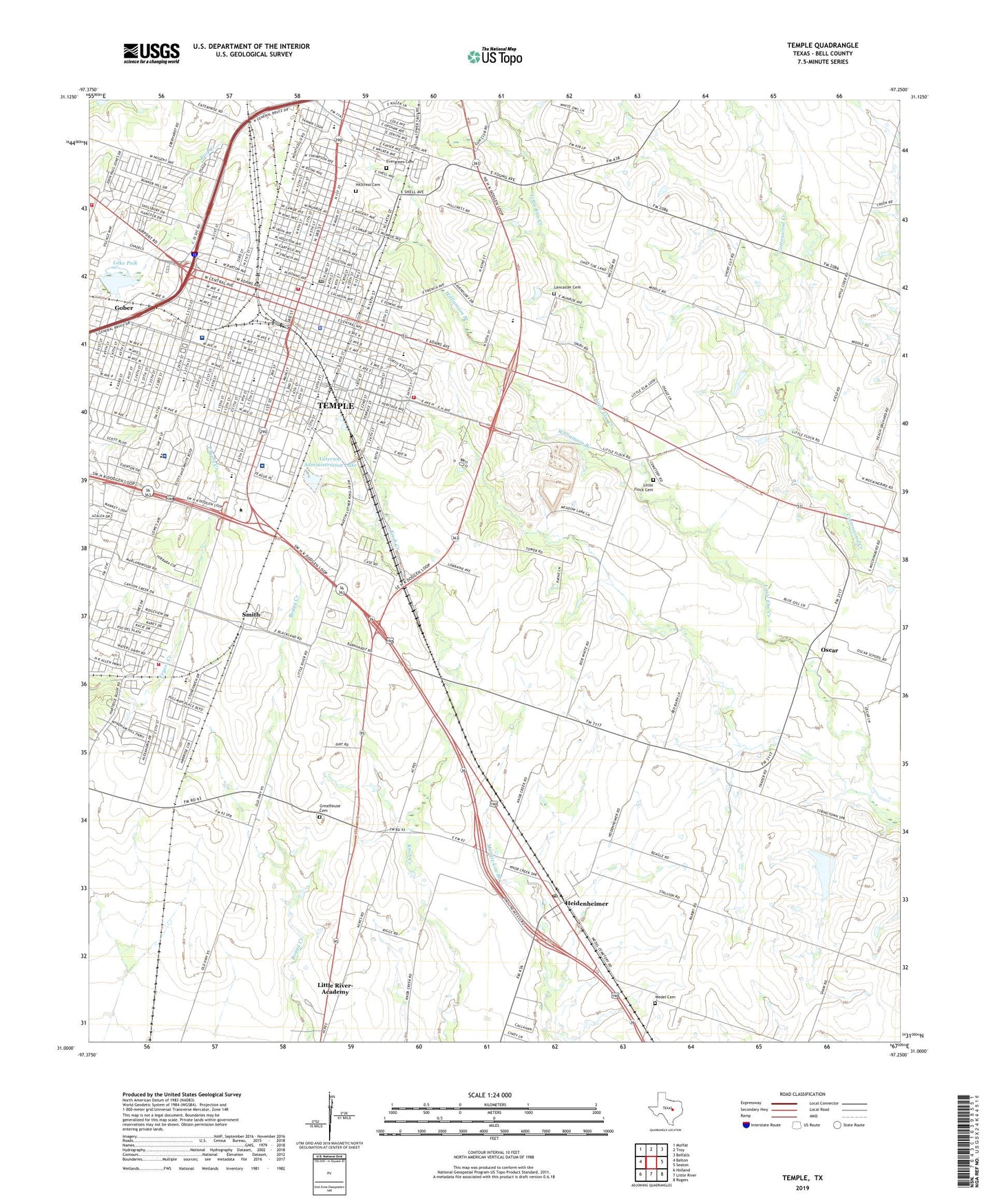
2022 topographic map quadrangle Temple in the state of Texas. Scale: 1:24000. Based on the newly updated USGS 7.5' US Topo map series, this map is in the following counties: Bell. The map contains contour data, water features, and other items you are used to seeing on USGS maps, but also has updated roads and other features. This is the next generation of topographic maps. Printed on high-quality waterproof paper with UV fade-resistant inks.
Quads adjacent to this one:
West: Belton
Northwest: Moffat
North: Troy
Northeast: Belfalls
East: Seaton
Southeast: Rogers
South: Little River
Southwest: Holland
This map covers the same area as the classic USGS quad with code o31097a3.
Contains the following named places: Antioch Church, Baker Field, Barclay-Bryan House, Baylor Scott and White Medical Center, Bell County Constable's Office Precinct 3, Bethune - Mega Comet Elementary School, Bethune School, Blackland Experimental Farm, Central Texas Emergency Medical Services, Chick Walker Junior Park, Church of Christ, Church of Christ Crestview, College Heights Baptist Church, Corinth Baptist Church, Country Club Dam, Covenant Fellowship Church, Crestview School, Czech Heritage Museum, Dickson School, Draughon Park, Dunbar High School, Eighth Street Baptist Church, El Divino Salvador Methodist Church, Emerson Elementary School, Emerson School, Eternal Life Baptist Church, Evangelical Brethren Church, Evergreen Cemetery, Faith Baptist Church, Ferguson House, Ferguson Park, First Church of God in Christ, First Lutheran Church, Free Church of God in Christ in Jesus Name, Freeman Heights School, Gober, Goodwill Mexican Baptist Church, Greater Zion Temple Church of God in Christ, Greathouse Cemetery, Hallford Baseball Field, Hector P Garcia Elementary School, Heidenheimer, Heidenheimer Post Office, Heights Baptist Church, Hillcrest Cemetery, Immanuel Baptist Church, Immanuel Lutheran Church, Jackson Park, James B Wilson Park, James Wilson Park, Jaycee Park, Jefferson Elementary School, Jefferson Park, Jefferson School, Jones Park, Knowd, Kyle Hotel, Lake Polk, Lamar Junior High School, Lamar Middle School, Lancaster Cemetery, Lanier School, Little Elm Field, Little Flock, Little Flock Cemetery, Memorial Baptist Church, Meredith - Dunbar Elementary School, Miller Park, Nettles park, New Covenant Baptist Church, New Life Prayer Fellowship Church, Olin E Teague Veterans Affairs Medical Center, Olin E Teague Veterans Center, Open Arms United Methodist Church, Open Door Community Church, Optimist Number 1 Field, Oscar, Our Lady of Guadalupe Church, Railroad and Pioneer Museum, Ray - Allen Elementary School, Reagan Elementary School, Reagan School, Reed Chapel Church of God Christ, Saint James Episcopal Church, Saint Marys School, Saint Paul United Methodist Church, Sammons Park, Santa Fe Hospital, Scott and White Memorial Hospital Heliport, Scott and White Park, Scott Elementary School, Scott School, Smith, Tarrant Park, Taylors Valley Baptist Church, Temple, Temple City Hall, Temple Division, Temple Fire and Rescue Station 1, Temple Fire and Rescue Station 2, Temple Fire and Rescue Station 4, Temple Fire and Rescue Station 5, Temple Fire Training Academy, Temple Golf Course and Country Club, Temple High School, Temple Jaycee Park, Temple Junior College, Temple Police Department, Temple Post Office, Texas A and M School of Medicine, Travis Junior High School, Travis Middle School, Vac Heliport, Vandiver School, Veterans Administration Dam, Veterans Administration Lake, Victory Missionary Baptist Church, Wedel Cemetery, Wheatley School, Wildcat Stadium, Williamson Branch, Woodson Field, ZIP Codes: 76501, 76508