MyTopo
Wichita Falls West Texas US Topo Map
Couldn't load pickup availability
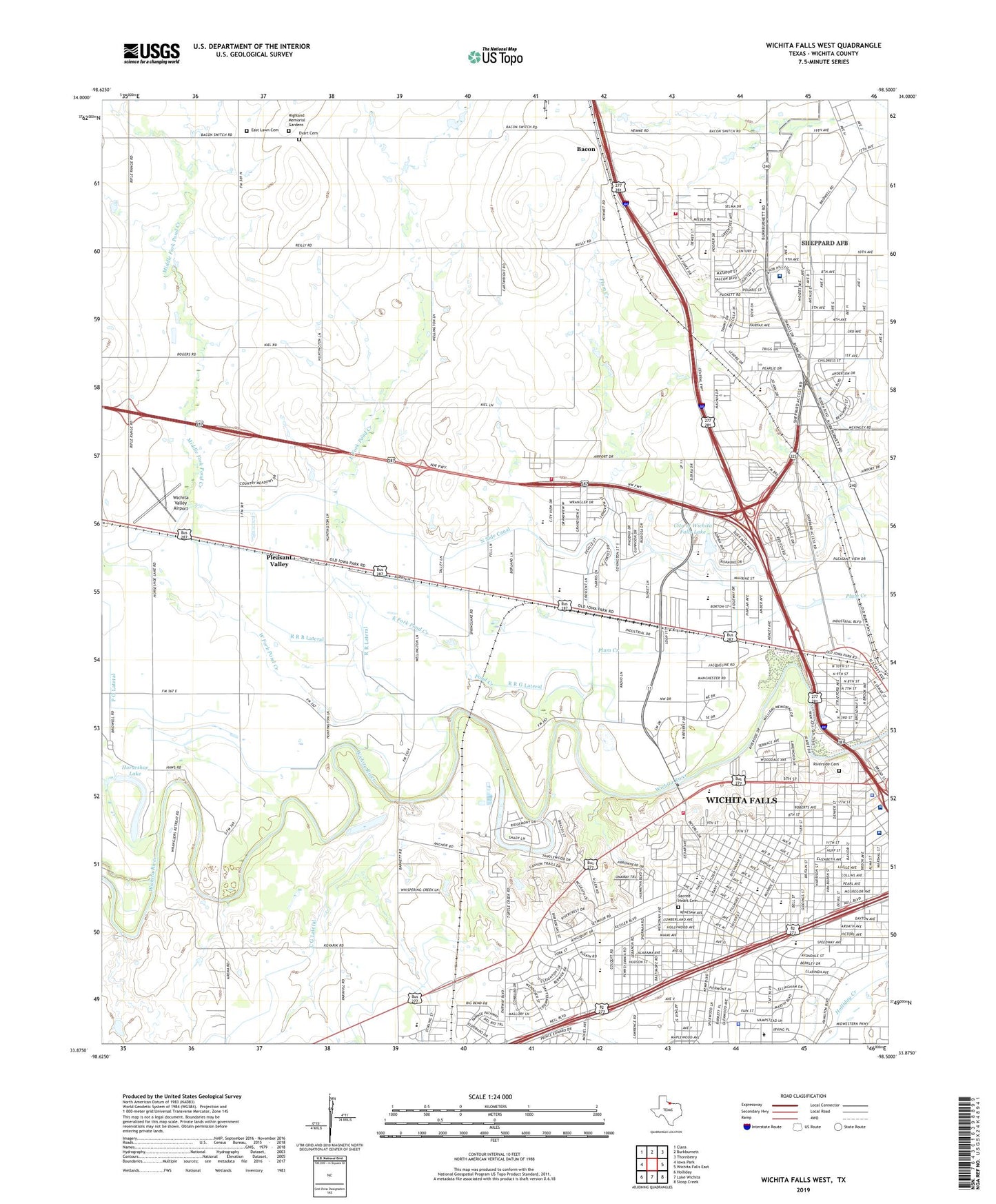
2022 topographic map quadrangle Wichita Falls West in the state of Texas. Scale: 1:24000. Based on the newly updated USGS 7.5' US Topo map series, this map is in the following counties: Wichita. The map contains contour data, water features, and other items you are used to seeing on USGS maps, but also has updated roads and other features. This is the next generation of topographic maps. Printed on high-quality waterproof paper with UV fade-resistant inks.
Quads adjacent to this one:
West: Iowa Park
Northwest: Clara
North: Burkburnett
Northeast: Thornberry
East: Wichita Falls East
Southeast: Sloop Creek
South: Lake Wichita
Southwest: Holliday
This map covers the same area as the classic USGS quad with code o33098h5.
Contains the following named places: Air - Evac Lifeteam 34 Wichita Falls, Alamo Elementary School, Alamo School, American Medical Response, Assumption of Mary Catholic Church, Bacon, Benjamin Frankin School, Bethania Hospital, Beverly Drive United Methodist Church, Birdwell Park, Bridwell Park, Brook Village Early Childhood, Burgess Elementary School, Burgess School, C G Lateral, Central Baptist Church, Christ United Presbyterian Church, Church of Christ, Church of Christ Gardens Edge, Church of Christ North Fourth, City of Wichita Falls, City of Wichita Falls Lake, City of Wichita Falls Lake Dam, City View Elementary School, City View Park, City View School, Coyote Stadium, Crockett Elementary School, Crockett School, East Fork Pond Creek, East Lawn Cemetery, Emmanual Baptist Church, Evart Cemetery, Fain Presbyterian Church, Fairview Assembly of God Church, First Church of God, First Pentecostal Church of God, First Pentecostal Holiness Church, First Primitive Baptist Church, First Seventh Day Baptist Church, Floral Heights Assembly of God Church, Franklin Elementary School, Grant Street Church of Christ, Grant Street Park, Hamilton Park, Hanes School, Harrell Learning Center, Harrell Park, Harrell School, Haynes Elementary School, Highland Church of God, Highland Memorial Gardens, Hirschi High School, Hirschi School, Horseshoe Lake, Houston Elementary School, Huey Elementary School, Huey School, Indian Heights Park, Jehovahs Witnesses North Congregation Church, John G Tower Elementary School, KAUZ-TV (Wichita Falls), KCRN-FM (Wichita Falls), KFDX-TV (Wichita Falls), Kirby Math - Science Center, KKCR-AM (Wichita Falls), KLLF-AM (Wichita Falls), KLUR-FM (Wichita Falls), KMOC-FM (Wichita Falls), KNIN-FM (Wichita Falls), KTLT-FM (Wichita Falls), KWFS-FM (Wichita Falls), KWFT-AM (Wichita Falls), Liberty Baptist Church, Lions Park, Lucy Park, Lucy Park Trail, Lynwood East Park, Martin Plaza Park, Middle Fork Pond Creek, Midwestern University, Morningside Historic District, Morningside Park, Morningside Post Office, North Side Baptist Church, North Side Canal, Notre Dame Catholic School Baseball Field, Notre Dame Catholic School Football Field, Notre Dame High School, Oildom, Our Lady Queen of Peace School, P O Lateral, Parker Square Shopping Center, Pleasant Valley, Pleasant Valley Baptist Church, Pond Creek, Primera Iglesia Asamblea de Dios Church, R R B Lateral, R R G Lateral, R R Lateral, Red River Hospital, Riverbend Nature Works Trail, Riverside Cemetery, Roselawn Park, Sacred Heart Cemetery, Saint Paul School, Sam Houston School, Scotland Ball Field, Scotland Park, Scotland United Methodist Church, Shasta Baptist Church, Sheppard Air Force Base, Sheppard Air Force Base Post Office, Sheppard Air Force Base School, Sheppard Air Force Base/Wichita Falls Municipal Airport, Sheppard Burkburnett School, Sheppard Hospital - 82nd Medical Group, Shiloh Baptist Church, Skyline Country Club, Sunset Terrace Park, Sunshine Yard, Tesco Park, Texas Department of Criminal Justice James V Allred Unit, Texas Highway Patrol Office - Wichita Falls, Thornberry Baptist Church, Town of Pleasant Valley, Twin Falls Drive-In, United Regional Hospital and Emergency Room, Unity Missionary Baptist Church, Weeks House, West Fork Pond Creek, West Foundation Elementary School, West Oil Field, Westover Hills Park, Wichita Falls Division, Wichita Falls Fire Department Station 4, Wichita Falls Fire Department Station 5, Wichita Falls Fire Department Station 7, Wichita Falls High School, Wichita Falls High School Track, Wichita Falls Police Department, Wichita Valley Airport, Wichita Valley Community House, William Benjamin Hamilton House, Zundelowitz Junior High School, ZIP Codes: 76306, 76309, 76311