MyTopo
Wichita Falls East Texas US Topo Map
Couldn't load pickup availability
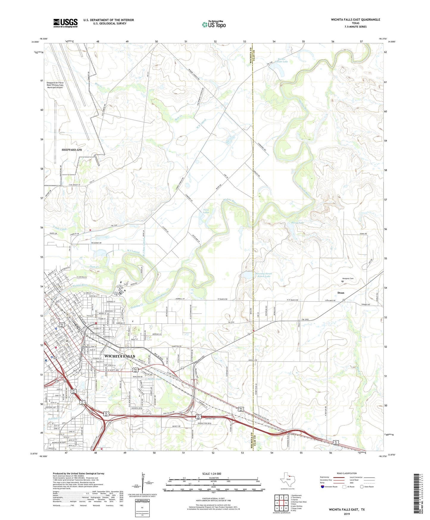
2022 topographic map quadrangle Wichita Falls East in the state of Texas. Scale: 1:24000. Based on the newly updated USGS 7.5' US Topo map series, this map is in the following counties: Wichita, Clay. The map contains contour data, water features, and other items you are used to seeing on USGS maps, but also has updated roads and other features. This is the next generation of topographic maps. Printed on high-quality waterproof paper with UV fade-resistant inks.
Quads adjacent to this one:
West: Wichita Falls West
Northwest: Burkburnett
North: Thornberry
Northeast: Charlie
East: Dean
Southeast: Jolly
South: Sloop Creek
Southwest: Lake Wichita
This map covers the same area as the classic USGS quad with code o33098h4.
Contains the following named places: Anderson Chapel African Methodist Episcopal Church, Antioch Baptist Church, Austin Elementary School, Austin School, Bear Creek, Bellevue Park, Bethlehem Missionary Baptist Church, Bonham Elementary School, Bonham School, Booker T Washington Junior High School, Bowie School, Bright Ideas Charter School, Cameron Gardens Volunteer Fire Department, Carrigan School, Church of God of Prophecy, Denver Tank, Denver Tank Dam, Donnell Park, El Buen Pastor United Methodist Church, Emmanuel Seventh Day Adventist Church, Faith Freewill Baptist Church, Fannin School, First Church of Christ, First Mexican Baptist Church, First Pentecostal Church, Friberg Cooper Church, Full Gospel Powerhouse Church of God in Christ, Greater Saint Mark Baptist Church, Henry Lake, Henry Lake Dam, Hodges-Hardy-Chambers House, Holland Education Center, Holland School, Holliday Creek, Iglesia Bautista Emanuel Church, Iglesia Libertad Bautista Church, Jalonic Park, Jefferson Street Baptist Church, Kell House Museum, Kempner Cemetery, Lamar Elementary School, Lamar Park, Lamar School, Lincoln Park, McGaha Elementary School, McGaha School, Messiah Baptist Church, Metropolitan Community Church of Wichita Falls, Miracle Church of God in Christ, Mitchells Chapel Church, Morning Star Baptist Church, Mount Calvary United Methodist Church, Mount Pleasant Baptist Church, Oklahoma Yards, O'Reilly Park, Parker Estate Lake, Parker Estate Lake Dam, Pecanway Baptist Church, Pentecostal Church of God in Christ, Pilgrims Rest Baptist Church, Pillar Ground Truth Church of God, Plum Creek, Progressive Baptist Church, Promise Hospital of Wichita Falls, Raymond, Regan School, Sacred Heart Catholic Church, Saint Matthews Baptist Church, Saint Paul Lutheran Church, Saint Paul Missionary Baptist Church, Seventy-seven Ranch, Seventy-Seven Ranch Lake, Seventy-Seven Ranch Lake Dam, Southside Baptist Church, Spudder Park, Travis School, Twin Lakes, United Methodist Church - Wichita Falls, W J Four Lateral, W J Lateral, W P Lateral, Washington - Jackson Math - Science Center, Washington School, Welch Street Church of Christ, Wichita County Constable's Office Precinct 1, Wichita County Jail, Wichita County Jail Sprague Annex, Wichita County Sheriff's Office, Wichita East Volunteer Fire Department, Wichita Falls, Wichita Falls City Hall, Wichita Falls Fire Department Station 1, Wichita Falls Fire Department Station 2, Wichita Falls Fire Department Station 3, Wichita Falls Independent School District Police Department, Wichita Falls Main Post Office, Wichita Falls Route Building, Williams Park, ZIP Code: 76301