MyTopo
Rochester Vermont US Topo Map
Couldn't load pickup availability
Also explore the Rochester Forest Service Topo of this same quad for updated USFS data
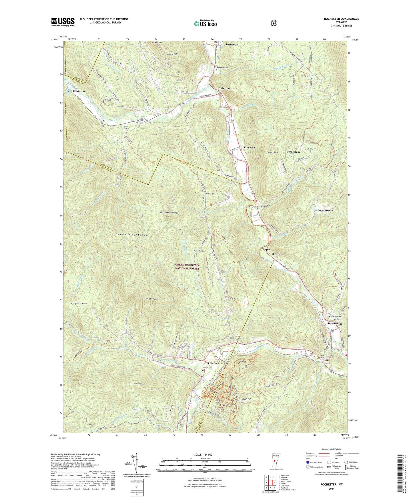
2024 topographic map quadrangle Rochester in the state of Vermont. Scale: 1:24000. Based on the newly updated USGS 7.5' US Topo map series, this map is in the following counties: Windsor, Rutland, Addison. The map contains contour data, water features, and other items you are used to seeing on USGS maps, but also has updated roads and other features. This is the next generation of topographic maps. Printed on high-quality waterproof paper with UV fade-resistant inks.
Quads adjacent to this one:
West: Mount Carmel
Northwest: Bread Loaf
North: Hancock
Northeast: Randolph
East: Bethel
Southeast: Delectable Mountain
South: Pico Peak
Southwest: Chittenden
This map covers the same area as the classic USGS quad with code o43072g7.
Contains the following named places: Angell Cemetery, Austin Hill, Bartlett Brook, Bayonne Camp, Betsy Bartlett Grave, Bingo Brook, Branch School, Brandon Brook, Breakneck Brook, Brown Brook, Brown School, Caryl Brook, Cold Brook, Corporation Brook, Emerson, Guernsey Brook, Hedgehog Knoll, Jerusalem, Jerusalem School, Kings Pond, Knights Hill, Liberty Hill, Little Wilcox Peak, Maple Hill School, Maplewood Cemetery, Mount Reeder, Nason Brook, New Boston, Parmenter Cemetery, Perkins Brook, Pittsfield, Pittsfield Post Office, Pittsfield Town Hall, Pittsfield Volunteer Fire Department, Red Spruce Seed Production Area, River School, Robinson, Rochester, Rochester Census Designated Place, Rochester Elementary / High School, Rochester Post Office, Rochester Ranger Station, Rogers Brook, Rogers Peak, Saint Dennis Church, Saint Elizabeths Catholic Church, South Branch Tweed River, South Hill, Stockbridge, Stockbridge Common Historic District, Stockbridge Post Office, Stockbridge Volunteer Fire Department, Talcville, Town of Pittsfield, Townsend Brook, Trail Head Ski Touring Center, Trail Head Winter Sports Area, Tupper, Tupper Cemetery, Tweed River, Village Cemetery, West Branch Tweed River, West Branch White River, White River Golf Course, White School, Wilcox Peak, Williams Mine, Wing Brook, Woodlawn Cemetery, ZIP Codes: 05762, 05772