MyTopo
Crozet Virginia US Topo Map
Couldn't load pickup availability
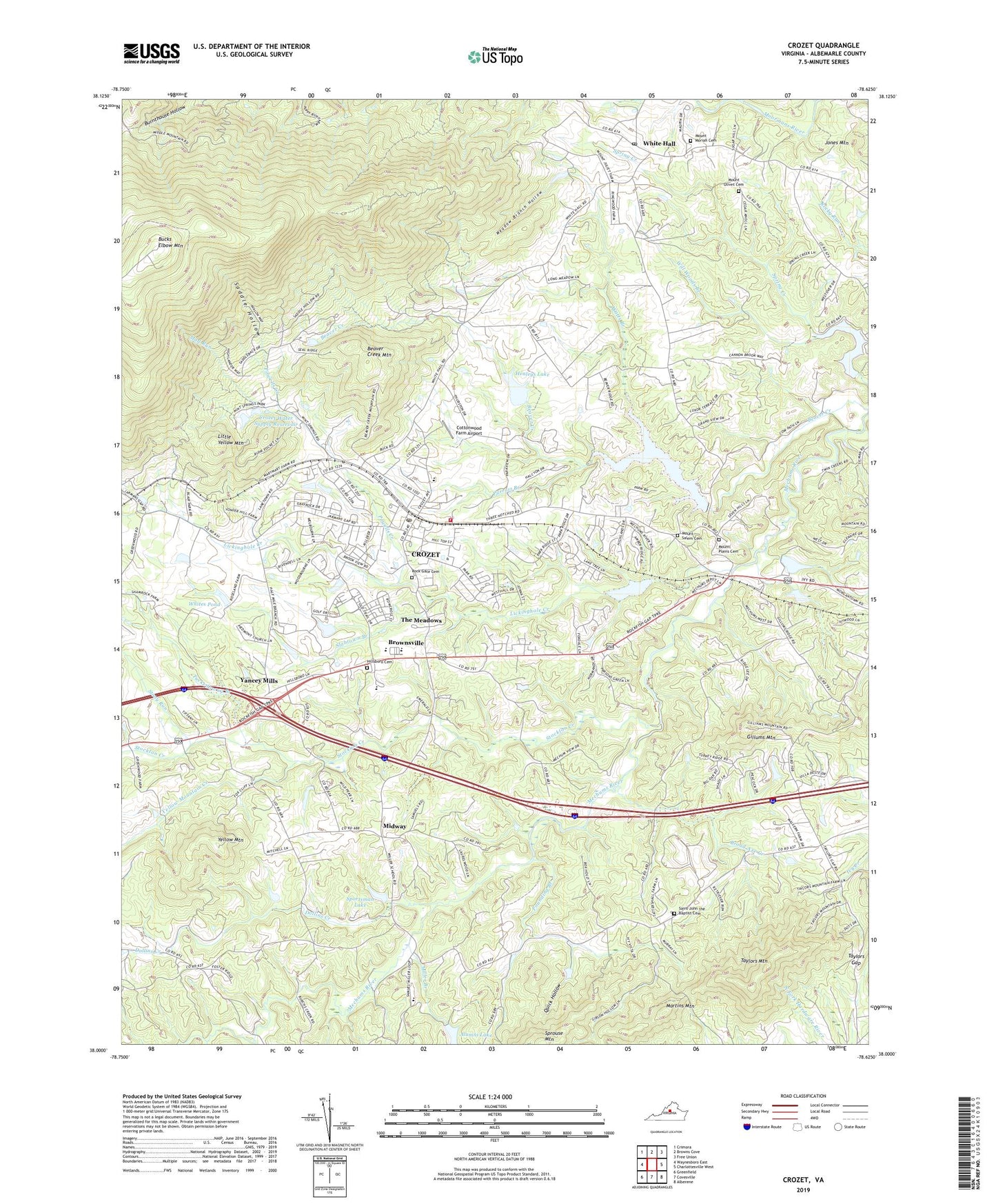
2022 topographic map quadrangle Crozet in the state of Virginia. Scale: 1:24000. Based on the newly updated USGS 7.5' US Topo map series, this map is in the following counties: Albemarle. The map contains contour data, water features, and other items you are used to seeing on USGS maps, but also has updated roads and other features. This is the next generation of topographic maps. Printed on high-quality waterproof paper with UV fade-resistant inks.
Quads adjacent to this one:
West: Waynesboro East
Northwest: Crimora
North: Browns Cove
Northeast: Free Union
East: Charlottesville West
Southeast: Alberene
South: Covesville
Southwest: Greenfield
This map covers the same area as the classic USGS quad with code o38078a6.
Contains the following named places: Alumni Lake, Beaver Creek, Beaver Creek Mountain, Beaver Creek Number One Dam, Beaver Creek Reservoir, Beaver Creek Reservoir Park, Beaver Hill Mobile Home Park, Bermbergers Dam, Bermbergers Pond, Broad Axe, Broad Axe Creek, Broad Axe School, Brookwood, Brownsville, Brownsville Elementary School, Bucks Elbow Mountain, Clover Farm, Cornerstone Church of Albemarle, Cottonwood Farm Airport, Country View, Crozet, Crozet Baptist Church, Crozet Census Designated Place, Crozet Elementary School, Crozet Methodist Church, Crozet Post Office, Crozet Volunteer Fire Department Station 5, Crozet Water Supply Dam, Crozet Water Supply Reservoir, Dollins Creek, Foothill Village, Freetown, Garnett Dam, Gillums Mountain, Glenaire, Henleys Dam, Henleys Lake, Hillsboro Cemetery, Hillsboro Church, Ivy Meadows, Ivy Woods, J T Henly Middle School, James Oldham Ordinary, Jarman Gap, Jarmans Mill, Jones Mountain, Lake Albemarle, Lake Albemarle Dam, Lake Road Church, Laurel Hills, Lickinghole Creek, Little Yellow Mountain, Mad Run, Martins Mountain, Maupins Orchard, Meadow Branch Hollow, Mechums River, Midway, Midway School, Miller Branch, Miller School Dam, Miller School of Albemarle, Mint Springs Recreation Area, Mount Moriah Cemetery, Mount Moriah Church, Mount Olivet Cemetery, Mount Olivet Church, Mount Plains Cemetery, Mount Plains Church, Mount Salem Cemetery, Mount Salem Church, Oak Hill School, Orchard Acres, Parkview, Parrott Branch, Peacock Hill, Peacock Hill Dam, Piedmont Church, Port-a-Ferry Farm, Pounding Branch, Powells Creek, Quick Hollow, Rock Gate Cemetery, Saddle Hollow, Saint John the Baptist Cemetery, Saint John the Baptist Church, Seven Oaks Farm, Skyline Crest, Slabtown Branch, Sneads Mobile Home Park, Sportsman Dam, Sportsman Lake, Sprouse Mountain, Stillhouse Creek, Stockton Creek, Stockton Mill Creek, Stony Run, Tabor Presbyterian Church, Taylors Gap, Taylors Mountain, Temple Hill, The Cedars, The Longhouse, The Meadows, Thurston, Tuckedaway Branch, Union Baptist Church, Watts Branch, Wayland Park, WCYK-AM (Crozet), WCYK-FM (Crozet), Western Albemarle High School, Western Albemarle Rescue Squad Station 5, Westover Hills, White Hall, White Hall Post Office, White Hall School, Whites Dam, Whites Pond, Will Woods Branch, Windy Hill, Yancey Mills, Yellow Mountain, Yellow Mountain Creek