MyTopo
Chesterfield Virginia US Topo Map
Couldn't load pickup availability
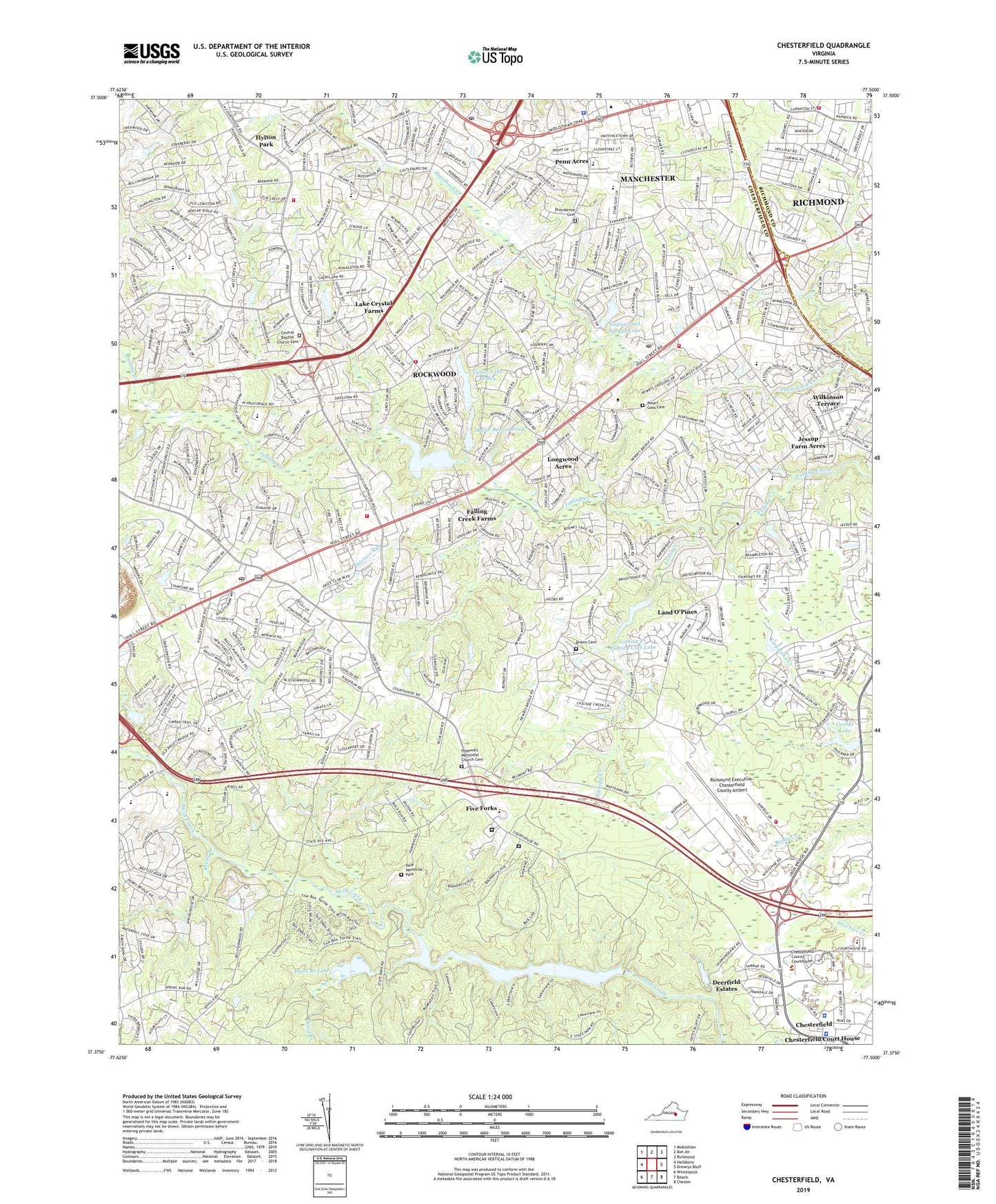
2019 topographic map quadrangle Chesterfield in the state of Virginia. Scale: 1:24000. Based on the newly updated USGS 7.5' US Topo map series, this map is in the following counties: Chesterfield, Richmond (city). The map contains contour data, water features, and other items you are used to seeing on USGS maps, but also has updated roads and other features. This is the next generation of topographic maps. Printed on high-quality waterproof paper with UV fade-resistant inks.
Quads adjacent to this one:
West: Hallsboro
Northwest: Midlothian
North: Bon Air
Northeast: Richmond
East: Drewrys Bluff
Southeast: Chester
South: Beach
Southwest: Winterpock
Contains the following named places: A M Davis Elementary School, Airport Station Number 15, Arch Village Shopping Center, Arrowhead, Bailey Bridge Middle School, Banner Christian School, Beaver Dam, Bellmont Mill, Beta Tech Richmond School, Bethany Place Baptist Church, Bon Air Post Office, Brown Grove Baptist Church Cemetery, Bryant and Stratton College Richmond Campus, Buford Shopping Center, Calvary Church, Camp Shawondasee, Central Baptist Church Cemetery, Central Church, Central Virginia Correctional Unit 13, Chalkley Elementary School, Charles City Volunteer Fire Department Station Number 3, Chesterfield, Chesterfield County, Chesterfield County Courthouse, Chesterfield County Fire / Emergency Medical Services Department - Administration, Chesterfield County Jail, Chesterfield County Museum, Chesterfield County Police Department Forensic, Chesterfield County Police Department Headquarters, Chesterfield County Police Department Midlothian District Station, Chesterfield County Police Department Vice, Chesterfield County Police Training Academy, Chesterfield County Public Library, Chesterfield County Sheriff's Office, Chesterfield Court House, Chesterfield Court House Census Designated Place, Chesterfield Detention Center, Chesterfield Fire and Emergency Medical Services Station 10 Wagstaff, Chesterfield Fire and Emergency Medical Services Station 15 Airport, Chesterfield Fire and Emergency Medical Services Station 2 Manchester, Chesterfield Fire and Emergency Medical Services Station 20 Courthouse Road, Chesterfield Fire and Emergency Medical Services Station 24, Chesterfield Historical Society Museum, Chesterfield Industrial Park, Chesterfield Juvenile Detention Home School, Chesterfield Women's Diverstion Center, Chestnut Hill, Child Care at the Arboretum, Chippenham Mall Shopping Center, Chippenham Square Shopping Center, Church of Christ, Church of the Epiphany, Clover Hill Baptist Church, Clover Hill District, Cloverleaf Mall Shopping Center, Commonwealth Christian School, Cosby Dam, Cosbys Lake, Crenshaw Elementary School, Dale District, Dale Memorial Park, Deerfield Estates, Elkhardt Church, Fairpines, Falling Creek Baptist Church, Falling Creek Farms, Fawnbrook, First Church of God, Five Forks, Forest View Volunteer Rescue Squad Station 3 Headquarters, G H Reid Elementary School, Genito Crossing Shopping Center, Genito Estates, Genito Post Office, Gills Country Day School, Good Hope School, Good News Free Will Baptist Church, Gospel Baptist Church, Gregorys Dam, Gregorys Pond, Heritage Christian Academy, Hopewell Church, Hopewell Methodist Church Cemetery, Horner Store, Horners Run, Hylton Park, Jacobs Road Elementary School, Jefferson Volunteer Fire Department, Jessup Farm Acres, Kings Forest, Kragmont, La Prade Branch Chesterfield County Library, Lake Crystal Farms, Land O'Pines, Licking Creek, Licking Creek Fishing Club, Licking Creek Fishing Club Dam, Licking Creek Fishing Club Lake, Longwood Acres, Lower Beaver Pond, Lower Beaver Pond Dam, Manchester, Manchester Census Designated Place, Manchester High School, Manchester Middle School, Manchester Volunteer Rescue Squad Station, Mayfair Estates, Monacan High School, Mount Giea Cemetery, Mount Giea Church, Murchies Mill, Napiers and Savage Dam, Napiers and Savage Lake, Nuttree Branch, O B Gates Elementary School, Oak Forest Baptist Church, Oakhaven Farms, Old Coach Hills, Oxbridge Square Shopping Center, Penn Acres, Pocahontas Acres, Pocahontas State Park, Pocahontas State Park Museum, Pocosham Park, Pocoshock Creek Post Office, Pocoshock Golf Course, Pre-Release Activities Center, Providence Cemetery, Providence Church, Providence Elementary School, Providence Golf Club, Providence Middle School, Qualla Farms, Ramsey Memorial United Methodist Church, Reams Road Elementary School, Reedy Branch, Richmond Christian School, Richmond Church, Richmond Executive-Chesterfield County Airport, Richmond Fire Department Station 23, Richmond Public Library La Prade Branch Library, Robinwood, Rock Castle Business Park, Rockwood Census Designated Place, Rockwood Park, Rockwood Square Shopping Center, Rolling Hills, Runnymede, Shannon Terrace, Sixty West Shopping Center, SkysStat 1 Base 6, Spring Creek Church, Swift Creek Dam, Swift Creek Farms, Swift Creek Lake, Third Branch, Third Branch Lake, Threehundred Sixty West Shopping Center, Tomahawk Academy School, Upper Beaver Pond Dam, Upper Lake Bexley, Victory Tabernacle Church of God, Virginia State Police MedFlight I, W W Gordon Elementary School, Wagstaff Station Number 10, Warwick Acres, Wedgewood, Wilkinson Terrace, Wiseville, Worthington Farms, ZIP Codes: 23236, 23832