MyTopo
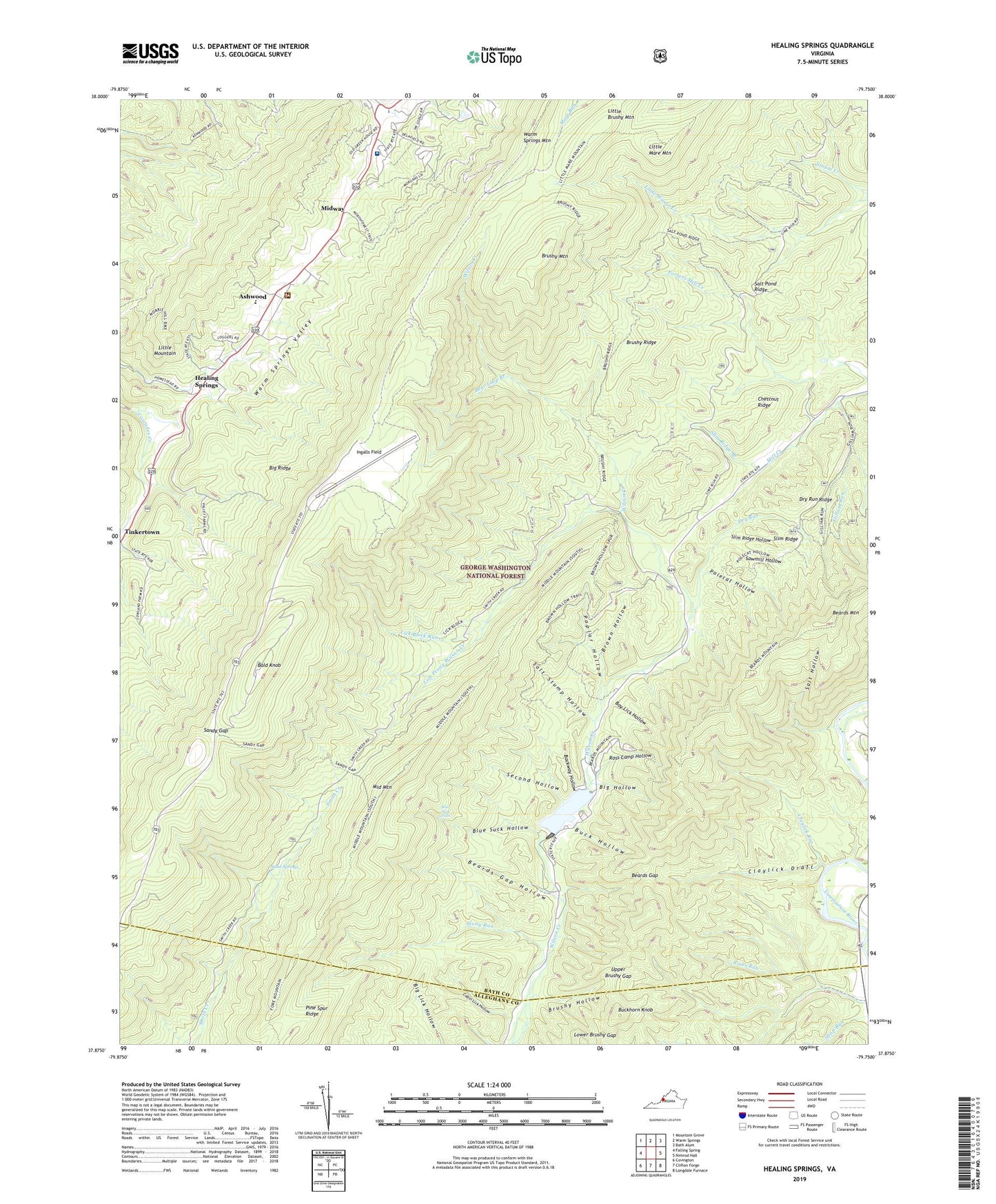
Healing Springs Virginia US Topo Map
Couldn't load pickup availability
Also explore the Healing Springs Forest Service Topo of this same quad for updated USFS data
2022 topographic map quadrangle Healing Springs in the state of Virginia. Scale: 1:24000. Based on the newly updated USGS 7.5' US Topo map series, this map is in the following counties: Bath, Alleghany. The map contains contour data, water features, and other items you are used to seeing on USGS maps, but also has updated roads and other features. This is the next generation of topographic maps. Printed on high-quality waterproof paper with UV fade-resistant inks.
Quads adjacent to this one:
West: Falling Spring
Northwest: Mountain Grove
North: Warm Springs
Northeast: Bath Alum
East: Nimrod Hall
Southeast: Longdale Furnace
South: Clifton Forge
Southwest: Covington
This map covers the same area as the classic USGS quad with code o37079h7.
Contains the following named places: Ashwood, Ashwood Elementary School, Backway Hollow, Bald Knob, Bald Knob FS Repeater Site, Bald Knob Lookout, Bath Community Hospital, Bay Lick Hollow, Bear Loop Branch, Beards Gap, Beards Gap Hollow, Beards Gap Trail, Beards Mountain, Bible Camp, Big Hollow, Big Ridge, Blue Suck Falls, Blue Suck Hollow, Blue Suck Trail, Bridle Trail, Brown Hollow, Brushy Hollow, Brushy Hollow Trail, Brushy Mountain, Brushy Ridge, Brushy Ridge Trail, Buck Hollow, Buck Lick Trail, Buckhorn Knob, Cabin Lick Hollow, Camp Kannata, Cascades Golf Club, Chestnut Ridge, Claylick Draft, Claylick Run, Deeds School, Douthat Dam, Douthat Lake, Douthat State Park, Dry Run, Dry Run Ridge, George Trail, Gillam Run, Gillam Run Trail, Gilliam Run Trail, Healing Springs, Hobby Horse Farm, Homested Hotel, Hot Springs, Hot Springs Presbyterian Church, Huffs Trail, Ingalls Field, Left Prong Wilson Creek, Lick Block Run, Little Brushy Mountain, Little Mare Mountain, Little Mountain, Lower Brushy Gap, Middle Hollow Trail, Middle Mountain, Middle Mountain Trail, Midway, Mount Olive Baptist Church, Mountain Side Trail, Mountain Top Trail, Oak Grove Church, Open Trail, Pine Tree Trail, Polecat Hollow, Poplar Hollow, Porters Mill Creek, Ross Camp Hollow, Ross Camp Trail, Sacred Heart Catholic Church, Saint Luke Episcopal Church, Salt Hollow, Salt Pond Ridge, Salt Pond Ridge Trail, Salt Stump Hollow, Salt Stump Trail, Sand Springs, Sandy Gap, Sandy Gap Trail, Sawmill Hollow, Second Hollow, Slim Ridge, Slim Ridge Branch, Slim Ridge Hollow, Stony Run, Stony Run Trail, Stouts Creek, The Pillars, Tinkertown, Tobacco House Ridge Trail, Trappers Lodge, Upper Brushy Gap, Valley Elementary School, Valley Springs District, Warm Springs Mountain, Warm Springs Valley, Warm Springs Work Center, Wilson Creek Trail, WWES-AM (Hot Springs), WXCF-FM (Clifton Forge)