MyTopo
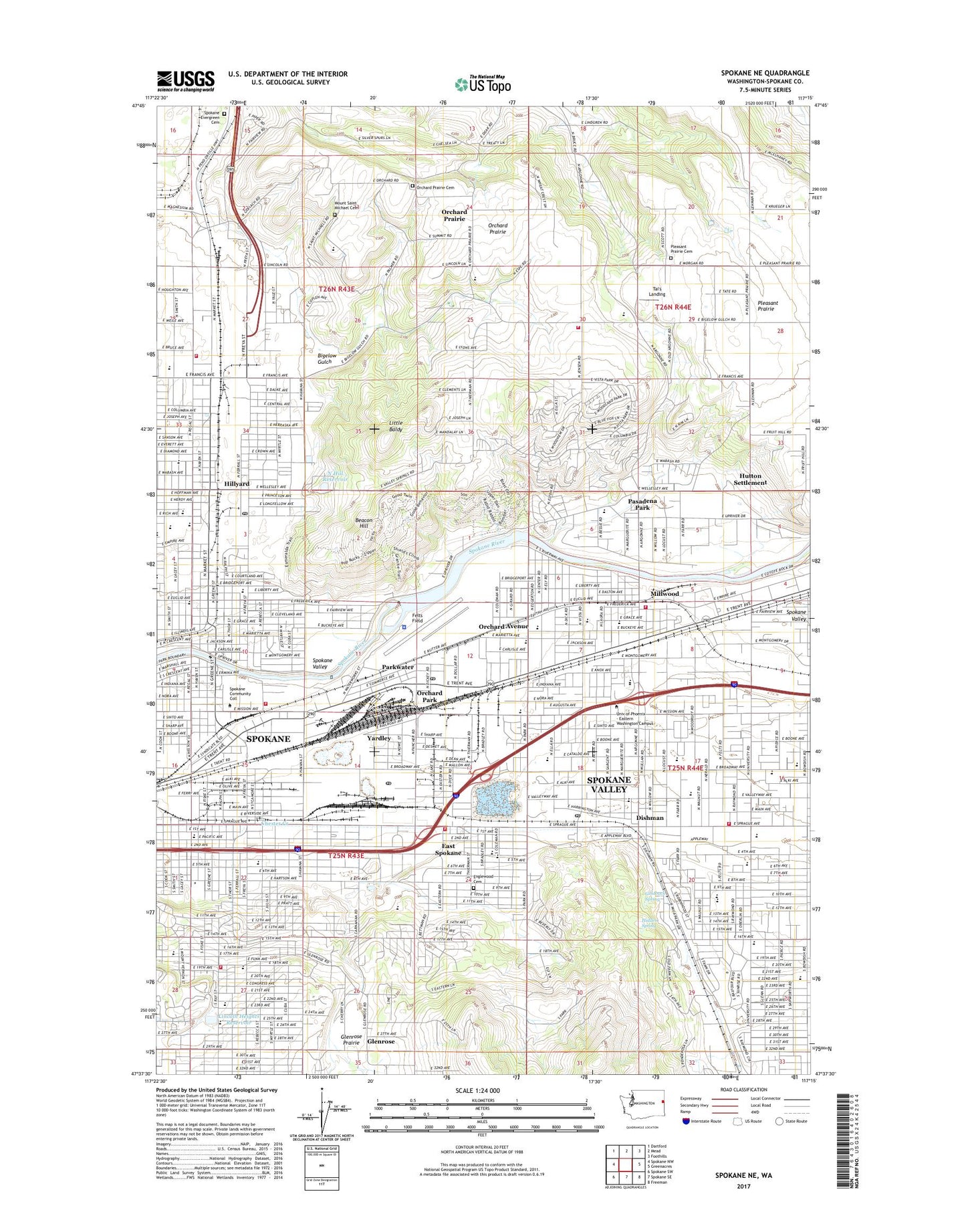
Spokane NE Washington US Topo Map
Couldn't load pickup availability
2023 topographic map quadrangle Spokane NE in the state of Washington. Scale: 1:24000. Based on the newly updated USGS 7.5' US Topo map series, this map is in the following counties: Spokane. The map contains contour data, water features, and other items you are used to seeing on USGS maps, but also has updated roads and other features. This is the next generation of topographic maps. Printed on high-quality waterproof paper with UV fade-resistant inks.
Quads adjacent to this one:
West: Spokane NW
Northwest: Dartford
North: Mead
Northeast: Foothills
East: Greenacres
Southeast: Freeman
South: Spokane SE
Southwest: Spokane SW
This map covers the same area as the classic USGS quad with code o47117f3.
Contains the following named places: Alcott School, All Saints Catholic School, Apple Center, Argonne Junior High School, Argonne Village Shopping Center, Arlington Elementary School, Balfour Park, Beacon Hill, Bemiss Elementary School, Bigelow Gulch, Bowdish Middle School, Broadway Elementary School, Camp Caro, Camp Sekani, Centennial Middle School, Chester Creek, Chief Garry Park, City of Millwood, Cooper Elementary School, Courtland Playground, Dishman, Dishman Hills Natural Area, Dishman Post Office, Dishman Square, East Spokane, East Town Shopping Center, Edgecliff Hospital, Edgecliff Park, Englewood Cemetery, Esmeralda Municipal Golf Course, Esperance, Fancher Memorial Airway Beacon, Felts Field, Franklin Elementary School, Gethsemane Lutheran School, Glenrose, Goldback Spring, Harmon Field, Hidden Spring, Hillyard, Hillyard Post Office, Hn(wa'(we'elshn, Hutton Settlement, Interstate Fairgrounds, Jim Hill Park, KCKO-AM (Millwood), Knox Park, Libby Center, Lincoln Heights Elementary School, Lincoln Heights Reservoir, Lincoln Heights Reservoir Dam, Lincoln Heights Shopping Center, Lincoln Park, Lincoln View Shopping Center, Little Baldy, Metro Carrier Annex Post Office, Millwood, Millwood Early Childhood Center, Millwood Park, Minnehaha Park, Morgan Acres, Morgan Acres Park, Mount Saint Michael Cemetery, Ness Elementary School, North Hill Reservoir, North Hill Reservoir Dam, Northwood Detention Pond Number One Dam, Northwood Detention Pond Number Two Dam, Orchard Avenue, Orchard Center Elementary School, Orchard Park, Orchard Prairie, Orchard Prairie Cemetery, Orchard Prairie Elementary School, Orchard Prairie Grange, Pantops, Parkwater, Parkwater Post Office, Pasadena Park, Pasadena Park Elementary School, Playfair Racetrack, Pleasant Prairie Cemetery, Pratt Elementary School, Regal Elementary School, Rotofly Incorporated Heliport, Saint John Vianney School, Saint Michael's Academy, Saint Michaels Mission State Park, Saint Paschal Catholic School and Educare, Saint Patrick Catholic School, Seth Woodard Elementary School, Shaw Middle School, Sheridan Elementary School, Spear, Spokane Christian Academy, Spokane Community College, Spokane County Fire District 9 Station 94, Spokane County Fire District 9 Station 98, Spokane Division, Spokane Evergreen Cemetery, Spokane Fire Department Station 14, Spokane Fire Department Station 8, Spokane Fire Department Training Complex, Spokane Police Academy, Spokane Valley, Spokane Valley Fire Department Station 1 - University, Spokane Valley Fire Department Station 2 - Millwood, Spokane Valley Fire Department Station 6 Edgecliff, Sullivan, Sunrise Elementary School, Tai's Landing, Underhill Playground, University City Shopping Center, University Elementary School, Upriver Dam, Upriver Dam Reservoir, Valley Mission Park, West Valley City School, West Valley High School, Yardley, ZIP Codes: 99206, 99212, 99217