MyTopo
Lobelia West Virginia US Topo Map
Couldn't load pickup availability
Also explore the Lobelia Forest Service Topo of this same quad for updated USFS data
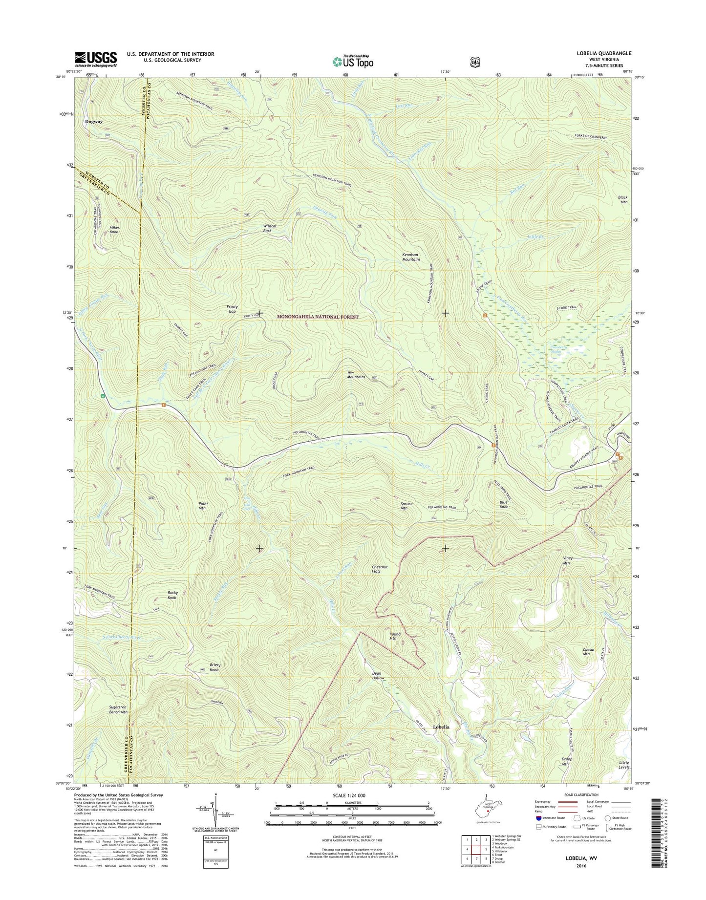
2023 topographic map quadrangle Lobelia in the state of West Virginia. Scale: 1:24000. Based on the newly updated USGS 7.5' US Topo map series, this map is in the following counties: Pocahontas, Greenbrier, Webster. The map contains contour data, water features, and other items you are used to seeing on USGS maps, but also has updated roads and other features. This is the next generation of topographic maps. Printed on high-quality waterproof paper with UV fade-resistant inks.
Quads adjacent to this one:
West: Fork Mountain
Northwest: Webster Springs SW
North: Webster Springs SE
Northeast: Woodrow
East: Hillsboro
Southeast: Denmar
South: Droop
Southwest: Trout
This map covers the same area as the classic USGS quad with code o38080b3.
Contains the following named places: Bear Run, Blue Knob, Briery Knob, Briery Knob Lookout Tower, Bruffeys Creek School, Caesar Mountain, Caesar Mountain School, Cave Run, Charles Creek, Chestnut Flats, Cow Pasture Trail, Cranberry Glades, Cranberry Glades Botanical Area, Cranberry Mountain Visitors Center, Darnell Run, Dean Hollow, Dogway, Eagles Camp, Eagles Camp Trail, Eagles School, Emmanuel Church, Falls of Hills Creek, Falls of Hills Creek Scenic Area, Forks of Cranberry Trail, Frosty Gap, Frosty Gap Trail, Glade Run, Kennison Mountain Trail, Kennison Mountains, Laurel Run, Left Branch North Fork Cherry River, Little Branch, Little Levels District, Little Red Run, Little Run, Lobelia, Lost Run, Mikes Knob, Mikes Knob Lookout Tower, Pocahontas Trail, Point Mountain, Red Run, Rocky Knob, Round Mountain, Rush Run, South Fork Shelter, Spruce Mountain, Spruce Run, Sugartree Bench Mountain, Viney Mountain, Wildcat Rock, ZIP Code: 24946