MyTopo
Menomonie North Wisconsin US Topo Map
Couldn't load pickup availability
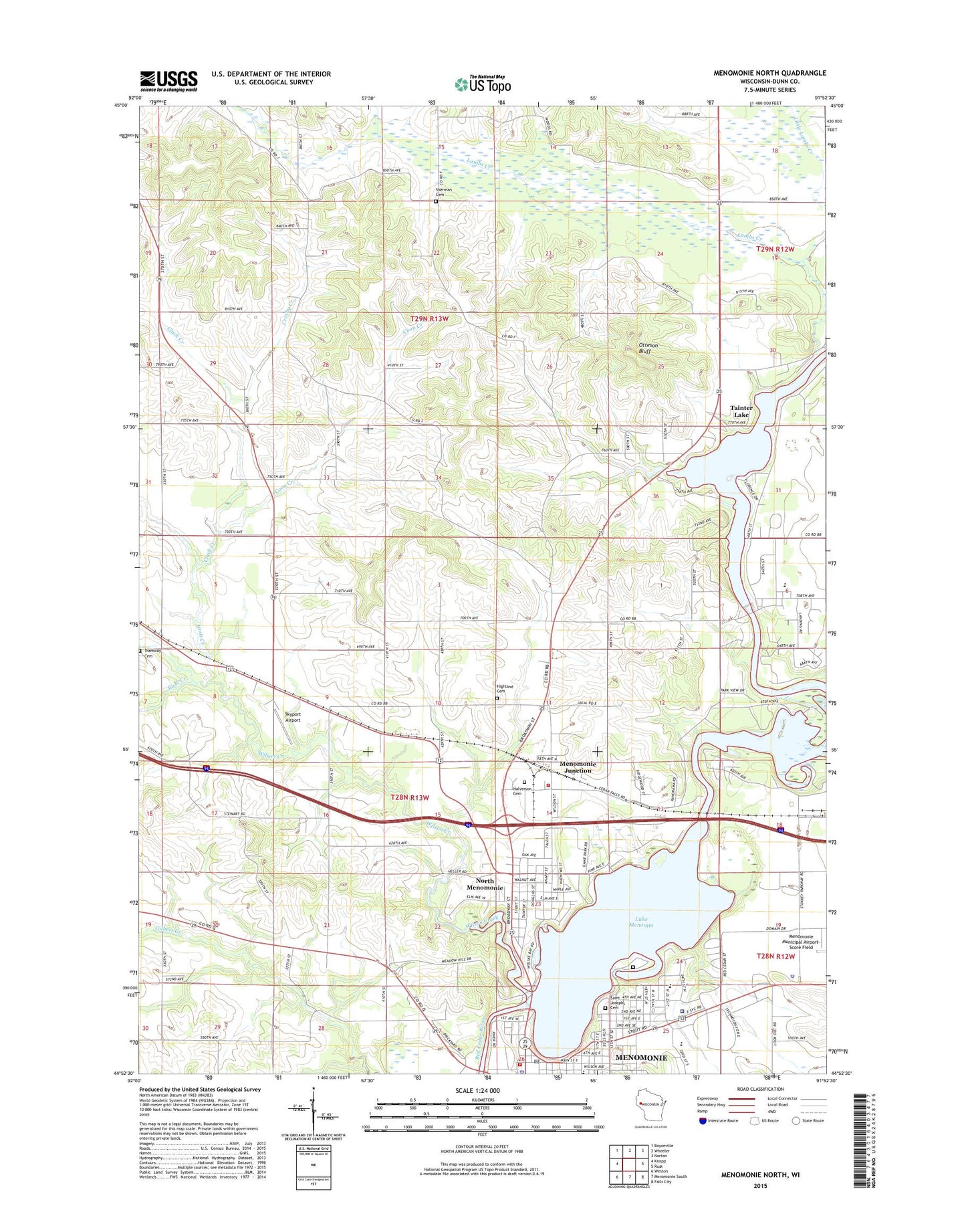
2022 topographic map quadrangle Menomonie North in the state of Wisconsin. Scale: 1:24000. Based on the newly updated USGS 7.5' US Topo map series, this map is in the following counties: Dunn. The map contains contour data, water features, and other items you are used to seeing on USGS maps, but also has updated roads and other features. This is the next generation of topographic maps. Printed on high-quality waterproof paper with UV fade-resistant inks.
Quads adjacent to this one:
West: Knapp
Northwest: Boyceville
North: Wheeler
Northeast: Norton
East: Rusk
Southeast: Falls City
South: Menomonie South
Southwest: Weston
This map covers the same area as the classic USGS quad with code o44091h8.
Contains the following named places: American Lutheran Home, Annis Creek, Blanchard School, Bowman Hall, Cedar Falls, Cedar Falls 1883C3 Dam, Cedar Falls Hydro Generating Station, Centenary Methodist Episcopal Church, Central School, Christ Lutheran Church, Christ Lutheran Halvorson Cemetery, Christs Church, City of Menomonie, Clack Creek, Clack School, Coon Creek, Crosby Creek, Dunn County, Dunn County Asylum, Dunn County Courthouse, Dunn County Fairgrounds, Dunn County Health Care Center, Dunn County Jail, Dunn County Poor Farm, Dunn County Sheriff's Department, East School, Evergreen Cemetery, First Church of God, First Congregational United Church of Christ, First Evangelical Church, Fleming Hall, Fryklund Hall, Good Shepard Free Lutheran Church, Harvey Hall, Highland Cemetery, Hillcrest School, Hovlid Hall, Huber Mobile Home Park, Hudson Road School, Ideal School, La Pointe Park, Lake Menomin, Lakeside Park, Lakeview Park, Lamb School, Lambs Creek, Little Lambs Creek, Mabel Tainter Memorial Building, Menomin Park, Menomonie, Menomonie 2WP983 Dam, Menomonie Campground, Menomonie City Hall, Menomonie Country Club, Menomonie Downtown Historic District, Menomonie Fire Department - Station 1, Menomonie Fire Department - Station 2 North Side, Menomonie Hydro Generating Station, Menomonie Junction, Menomonie Police Department, Menomonie Post Office, Myrtle Werth Medical Center, Myrtle Werth Medical Center Heliport, North Menomonie, North School, Oaklawn Elementary School, Otteson Bluff, Point Comfort Park, Roach School, Rush Creek, Saint Joseph School, Saint Josephs Catholic Church, Saint Joseph's Cemetery, Sanna Park, Sherman Cemetery, Skyport Airport, Tainter Lake 1667, Town of Menomonie, Town of Sherman, Tramway Church, Tramway School, University of Wisconsin - Stout, University of Wisconsin Stout Police Department, Wakanda Elementary School, Wakanda Park, Wigen Hall, Wilson Creek, Wilson Park, Wilson Place Museum, Wolske Bay Marina