MyTopo
Bryant Arkansas US Topo Map
Couldn't load pickup availability
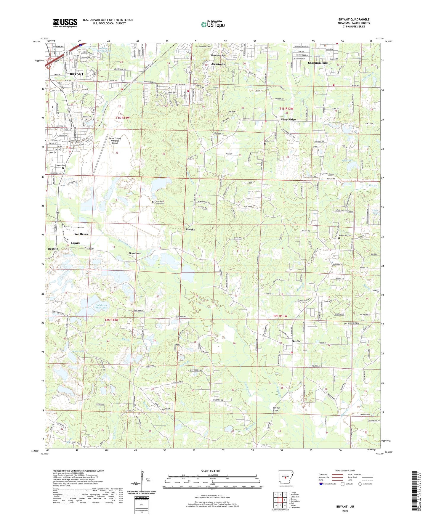
2024 topographic map quadrangle Bryant in the state of Arkansas. Scale: 1:24000. Based on the newly updated USGS 7.5' US Topo map series, this map is in the following counties: Saline. The map contains contour data, water features, and other items you are used to seeing on USGS maps, but also has updated roads and other features. This is the next generation of topographic maps. Printed on high-quality waterproof paper with UV fade-resistant inks.
Quads adjacent to this one:
West: Benton
Northwest: Congo
North: Alexander
Northeast: Little Rock
East: Spring Lake
Southeast: Cane Creek
South: Belfast
Southwest: Tull
This map covers the same area as the classic USGS quad with code o34092e4.
Contains the following named places: Abundant Life Center Assembly of God Church, African Camp Mine, Alexander Cemetery, Alexander Central Fire Station, Alexander Hill Mine, Alexander Human Development Center, Alexander Mountain, Arkansas Childrens Colony McRae Unit, Ashley Park, Ben Ball Bridge, Bertha Extension Mine, Bertha Mine, Bertha Underground Mine, Bethel Church, Bizzell Mine, Blue Branch, Brier Lick Branch, Brooks, Brushy Creek, Bryant, Bryant Branch Saline County Public Library, Bryant Cemetery, Bryant Church of Christ, Bryant City Hall, Bryant Elementary School, Bryant Fire Department Station 1, Bryant Fire Department Station 2, Bryant High School, Bryant Junior High School, Bryant Middle School, Bryant Mine, Bryant Oaks, Bryant Police Department, Bryant Post Office, Bryant Stadium, Butler Cemetery, Calvary Church, Canal Number 1 Mine, Canal Number 2 Mine, Careywood, Cargill Mine, Cargill North Shaft Mine, Cargill South Shaft Mine, Childress Mine, China Grove Cemeteries, City of Alexander, City of Bryant, City of Shannon Hills, Cleveland Mine, Cleveland-Evans Mine, Cold Spring Branch, Covington Number 4 Mine, Covington Number 5 Mine, Davis Main Portal Mine, Dirtdauber, Dotty Lake, Dry Creek, East Maud Mine, East Neilson Mine, East Ozark Mine, Ella Mine, Elrod Mine, Emory Branch, Evergreen, Fairview Church, Fairview School, First Baptist Church, First Church, First Southern Baptist Church, First United Methodist Church, Fletcher Mine, Gates Mine, Globe Mine, Goodman, Grace Missionary Baptist Church, Granite Branch Mine, Gray East Pit Mine, Gray West Pit Mine, Guiding Light Church, Hogue-Fletcher Mine, Hurricane, Hurricane Mine, Immanuel Church, Indian Springs Baptist Church, Indian Springs Lake, Johnson New Pit Mine, Johnson Old Pit Mine, Julia Mine, King Lake, King Lake Dam, KXIX-FM (Sheridan), Lantz Mine, Lignite, Martin Mine, Mary Mine, McDonald Mine, McPherson Cemetery, Middle Maud Mine, Midwest Mine, Mine 14, Moren Branch, Mount Olive Church, Mount Olive School, Muddy Branch, Neilson Mine, Northeast Saline County Fire Department Station 1, Northeast Saline County Fire Department Vimy Ridge Station, Norton Mine, Old Brown Mud Lake Dam, Old Brown Mud Lakes, Ozark 24 Mine, Pine Haven, Plainview Church, Pleasant Hill Baptist Church, Quapaw North Pit Mine, Quapaw South Pit Mine, Raintree Acres, Robert L Davis Elementary School, Rowland Mine, Saline County Regional Airport, Sardis, Sardis Census Designated Place, Sardis School, Sardis United Methodist Church, Sardis Volunteer Fire Department, Section 10 Mine, Section 14 East Pit Mine, Section 14 West Pit Mine, Section 15 Mine, Section 26 Mine, Shannon Hills, Shannon Hills City Hall, Shannon Hills Police Department, Stringtown Mine, Styres Lake, Styres Lake Dam, Surge Pond, Surge Pond Dam, Thomas McRae Tuberculosis Home, Town of Bauxite, Townsend Mine, Township of Bryant, Township of Hurricane, Township of Otter, Twin Oaks, Ulmer Mine, Vimy Ridge, Vimy Ridge Church, West Elrod Mine, West Maud Extension Mine, West Maud Mine, West Ozark Mine, Wilbur Mills Park, Woodland Hills, Woodland Hills Volunteer Fire Department Station 2, ZIP Codes: 72011, 72022, 72103