MyTopo
Felton California US Topo Map
Couldn't load pickup availability
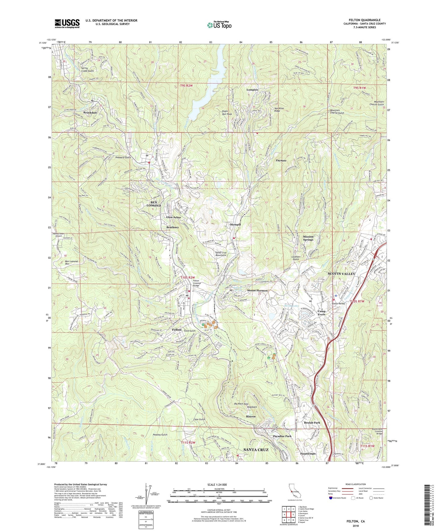
2021 topographic map quadrangle Felton in the state of California. Scale: 1:24000. Based on the newly updated USGS 7.5' US Topo map series, this map is in the following counties: Santa Cruz. The map contains contour data, water features, and other items you are used to seeing on USGS maps, but also has updated roads and other features. This is the next generation of topographic maps. Printed on high-quality waterproof paper with UV fade-resistant inks.
Quads adjacent to this one:
West: Davenport
Northwest: Big Basin
North: Castle Rock Ridge
Northeast: Los Gatos
East: Laurel
Southeast: Soquel
South: Santa Cruz
Southwest: Santa Cruz OE W
This map covers the same area as the classic USGS quad with code o37122a1.
Contains the following named places: Alba Creek, Alba School, American Medical Response Santa Cruz Division, Bald Mountain School, Baymonte Christian School, Bean Creek, Ben Lomond, Ben Lomond Census Designated Place, Ben Lomond County Park, Ben Lomond Fire Protection District, Ben Lomond Post Office, Ben Lomond School, Bennett Creek, Beulah Park, Beulah Park Conference Grounds, Big Rock Hole, Big Rock Hole Trail, Big Tree Grove, Blake Hammond Manor School, Boulder Brook, Boulder Creek Elementary School, Boulder Creek High School, Brackney, Branciforte Covered Bridge, Branciforte Picnic Grounds, Brook Knoll Elementary School, Brookdale, Brookdale Census Designated Place, Brookdale Post Office, Buckeye Trail, Bull Creek, Camp Evers, Camp Evers Shopping Center, Camp Wasibo, Canada Del Rincon En El Rio San Lorenzo De Santa Cruz, Cathedral Redwoods, Christian Conference Grounds, City of Scotts Valley, Clear Creek, Community Covenant Church, Community Foursquare Church of Scotts Valley, Deans Creek, Department of Forestry and Fire Protection Station 31 Felton Fire Station, Diversion Dam Trail, Eagle Creek, Eagle Creek Trail, Eagle Dell Peak, Fall Creek, Felton, Felton Branch Santa Cruz City-County Library, Felton Census Designated Place, Felton Covered Bridge, Felton Covered Bridge County Park, Felton Fair Shopping Center, Felton Fire Protection District, Felton Post Office, Felton Presbyterian Church, Felton Quarry, Ferndell Creek, Fritch Creek, Garden of Eden, George Washington Memorial Grove, Glen Arbor, Gold Gulch, Gold Gulch Creek, Graham Plaza Shopping Center, Graham Trail, Henry Cowell Redwoods State Park, Henry Cowell Redwoods State Park Headquarters, Highlands County Park, Hogsback, Hubbard Gulch, Juvenile Hall Community School, Kings Village Shopping Center, KZSC-FM (Santa Cruz), Lake Lompico, Loch Lomond, Lockhart Gulch, Lodato Park, Lompico, Lompico Census Designated Place, Lompico Creek, Love Creek, MacDorsa Park, Mackenzie Creek, Malosky Creek, Manson Creek, Marshall Creek, Meadow Trail, Mill Creek, Mission Springs, Mount Cross Camp, Mount Hermon, Mount Hermon Census Designated Place, Mount Hermon Post Office, Mountain Charlie Gulch, Newell 23-002 Dam, Newell Creek, Olympia, Ox Road Trail, Paradise Park, Paradise Park Census Designated Place, Pasatiempo, Pasatiempo Census Designated Place, Pasatiempo Golf Course, Pine Trail, Powder Mill Creek, Powder Mill Fire Road Trail, Powder Mill Trail, Quail Hollow Creek, Quail Hollow Elementary School, Redwood Glen Camp, Redwood Glen School, Redwood Loop Trail, Redwood Springs, Rincon, Rincon Fire Road Trail, River Trail, Roaring Camp, Roaring Camp Depot, Ruins Creek, San Augustin, San Augustin Catholic Church, San Lorenzo Valley Elementary School, San Lorenzo Valley High School, San Lorenzo Valley Middle School, Santa Cruz Big Trees County Park, Santa Cruz County, Santa Cruz Mountain Area State Parks Headquarters, Santa Cruz Probation Center, Santa Cruz Waldorf School, Santa Cruz Water Treatment Plant, Scotts Valley, Scotts Valley Branch Santa Cruz City-County Library, Scotts Valley Chamber of Commerce, Scotts Valley City Hall, Scotts Valley Community Bible Church, Scotts Valley Fire District Station 1, Scotts Valley Fire District Station 2, Scotts Valley First Baptist Church, Scotts Valley High School, Scotts Valley Middle School, Scotts Valley Police Department, Scotts Valley Post Office, Scotts Valley Square Shopping Center, Scotts Village Shopping Center, Sequoia Industrial Park, Shingle Mill Creek, Siltanen Community Park, Smith Creek, South Fall Creek, Spring Creek Gulch, Spring Lakes, The Mystery Spot, University of California Santa Cruz Fire Department, Valley Garden Golf Course, Van Allen Ridge, White Oak High School, Zayanta, Zayante, Zayante Census Designated Place, Zayante Creek, Zayante Fire Protection District Station 1, Zayante Fire Protection District Station 2, Zayante Post Office, ZIP Codes: 95005, 95007, 95018, 95041, 95060, 95066