
MyTopo
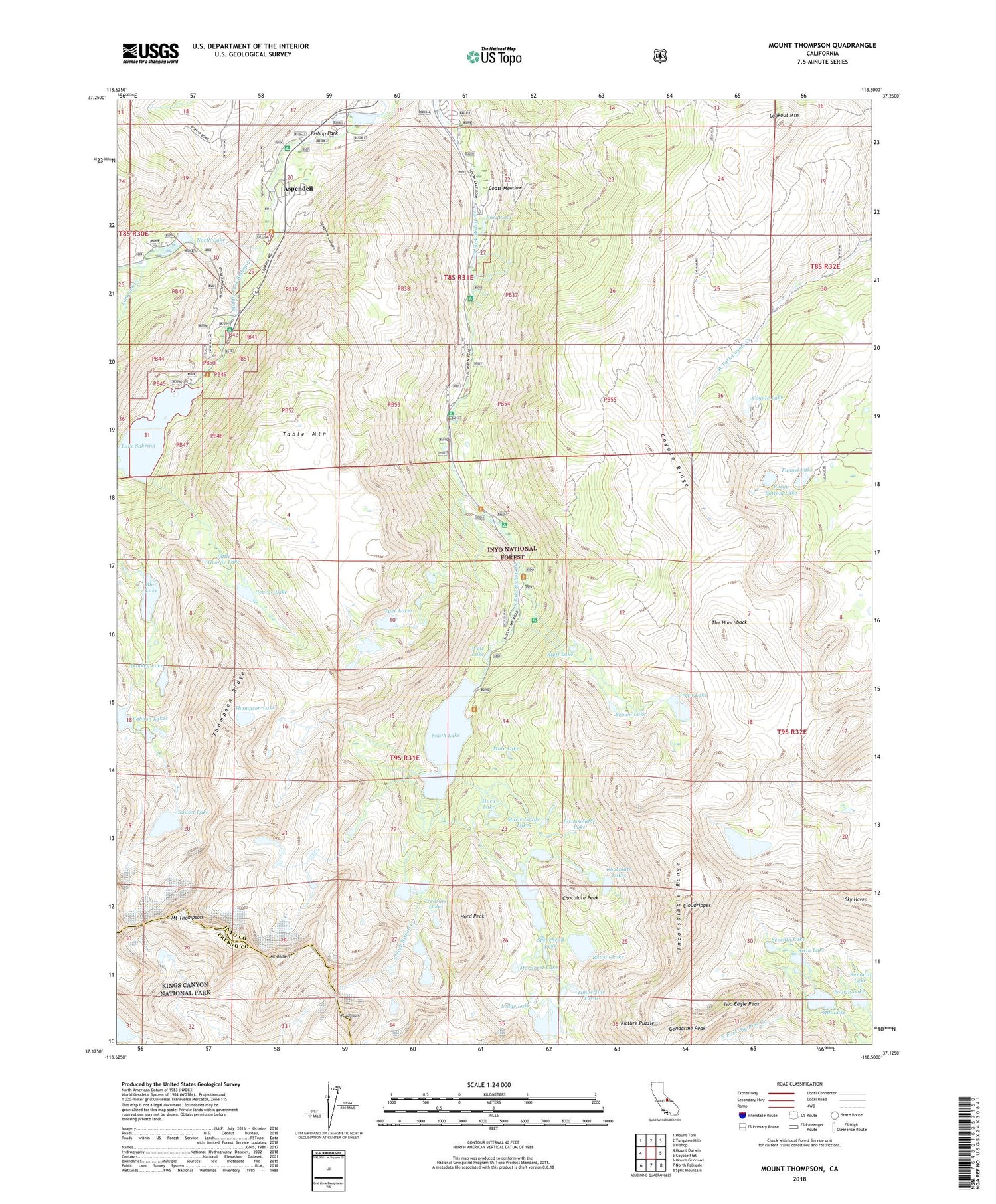
Mount Thompson California US Topo Map
Couldn't load pickup availability
Also explore the Mount Thompson Forest Service Topo of this same quad for updated USFS data
2021 topographic map quadrangle Mount Thompson in the state of California. Scale: 1:24000. Based on the newly updated USGS 7.5' US Topo map series, this map is in the following counties: Inyo, Fresno. The map contains contour data, water features, and other items you are used to seeing on USGS maps, but also has updated roads and other features. This is the next generation of topographic maps. Printed on high-quality waterproof paper with UV fade-resistant inks.
Quads adjacent to this one:
West: Mount Darwin
Northwest: Mount Tom
North: Tungsten Hills
Northeast: Bishop
East: Coyote Flat
Southeast: Split Mountain
South: North Palisade
Southwest: Mount Goddard
This map covers the same area as the classic USGS quad with code o37118b5.
Contains the following named places: Andrews Camp, Aspen Meadow Campground, Aspendell, Baboon Lakes, Baker-Green Lakes Trailhead, Big Pine Lakes, Bishop Creek 104-033 Dam, Bishop Park, Bishop Park Campground, Bishop Park Group Campground, Bishop Prospect, Blue Lake, Bluff Lake, Brackett Prospect, Brown Lake, Cardinal Mine, Chocolate Lakes, Chocolate Peak, Circle S Ranch, Cloudripper, Coats Meadow, Coyote Lake, Coyote Ridge, Donkey Lake, Ems Pond, Fifth Lake, Four Jeffrey Campground, Fourth Lake, Funnel Lake, Gendarme Peak, George Lake, Glacier Camp, Green Lake, Hillside 104-030 Dam, Hurd Lake, Hurd Peak, Inconsolable Lake, Inconsolable Range, Intake 2 Picnic Site, Intake Campground, Jawbone Canyon, La Hupp Picnic Area, Lake Sabrina, Lamarck Creek, Ledge Lake, Lindner Prospect, Little George Lake, Long Lake, Lookout Mountain, Margaret Lake, Marie Louise Lakes, Merrill Prospect, Mount Gilbert, Mount Johnson, Mount Thompson, Mountain Glen Campground, Mule Lake, North Fork Lamarck Creek, North Lake, North Lake 104-036 Dam, North Lake Picnic Site, North Lake Trailhead, Parchers Camp, Picture Puzzle, Rainbow Pack Station, Rocky Bottom Lake, Ruwau Lake, Sabrina 104-032 Dam, Sabrina Boating Site, Sabrina Campground, Sabrina Lake Trailhead, Saddlerock Lake, Salty Peterson Mine, Schober Mine, Seventh Lake, Sixth Lake, Sky Haven, South Lake, South Lake Picnic Area, South Lake-Bishop Pass Trailhead, Spearhead Lake, Stevens Prospect, Sunset Lake, Table Mountain, Table Mountain Campground, The Hunchback, Thompson Lake, Thompson Ridge, Thunder and Lightning Lake, Timberline Tarns, Treasure Lakes, Two Eagle Peak, Tyee Lakes, Tyee Trailhead, Waterfall Prospect, Weir Lake, Willow Campground


