MyTopo
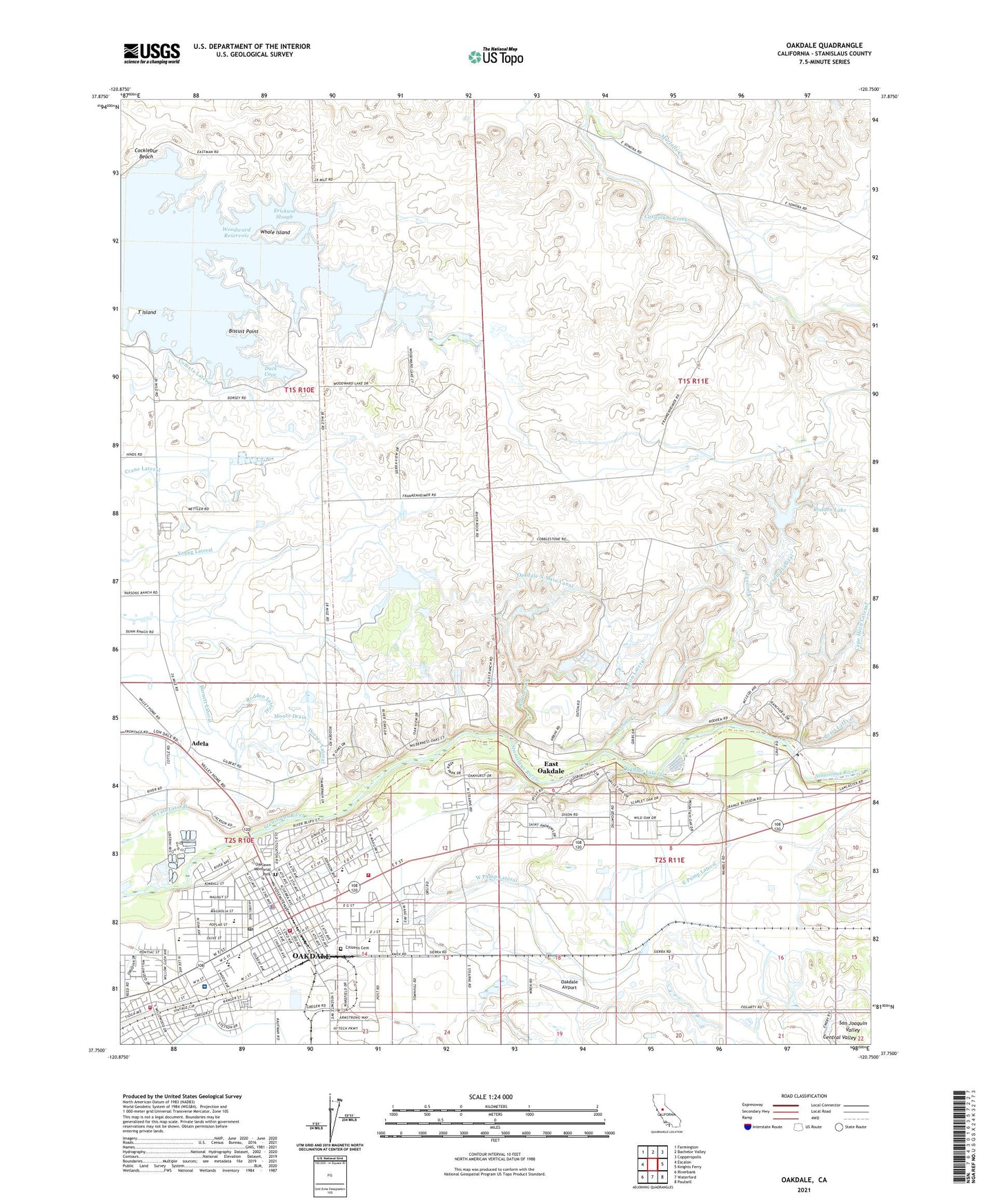
Oakdale California US Topo Map
Couldn't load pickup availability
2021 topographic map quadrangle Oakdale in the state of California. Scale: 1:24000. Based on the newly updated USGS 7.5' US Topo map series, this map is in the following counties: Stanislaus. The map contains contour data, water features, and other items you are used to seeing on USGS maps, but also has updated roads and other features. This is the next generation of topographic maps. Printed on high-quality waterproof paper with UV fade-resistant inks.
Quads adjacent to this one:
West: Escalon
Northwest: Farmington
North: Bachelor Valley
Northeast: Copperopolis
East: Knights Ferry
Southeast: Paulsell
South: Waterford
Southwest: Riverbank
This map covers the same area as the classic USGS quad with code o37120g7.
Contains the following named places: Adams Lateral, Adela, Birnbaum Lateral, Biscuit Point, Booth School, Brennan Park, Burnett Lateral, Church of Christ, Citizens Cemetery, City of Oakdale, Clavey Lateral, Clavey Siphon, Cloverland Elementary School, Cocklebur Beach, Collins Lateral, Dixon Lateral, Dorada Park, Dorsey Lateral, Duck Cove, East Clavey Lateral, East Oakdale, East Oakdale Census Designated Place, East Pump Lateral, Eastside School, Eaton Lateral, Erickson Slough, Fair Oaks Elementary School, Fair Oaks Park, First Baptist Church, First Church of Christ Scientist, Free Methodist Church, Gilbert Park, Gray Lateral, Hi Line Lateral, Hoekstra Dairy, Kerr Park, Lesnini Creek, Lesnini Lateral, Magnolia Elementary School, Martells Creek, Oak Valley Care Center, Oak Valley Hospital, Oak Valley Park, Oakdale, Oakdale Adult Education School, Oakdale Airport, Oakdale Branch Stanislaus County Free Library, Oakdale Bridge, Oakdale City Fire Department Station 1, Oakdale City Fire Department Station 2, Oakdale City Hall, Oakdale Division, Oakdale Golf and Country Club, Oakdale Joint Union High School, Oakdale Junior High School, Oakdale Lateral, Oakdale North Main Canal, Oakdale Police Department, Oakdale Post Office, Oakdale Recreation Area, Oakdale Rodeo Grounds, Oakdale Rural Fire Protection District Station 1, Oakdale Sewage Plant, Oakdale South Main Canal, Oakdale Sportsman Club, Oaklawn Memorial Park, Orange Blossom Bridge, Orange Blossom Recreation Area, Peart Lateral, Pentecostal Church of God, Rancheria Del Rio Estanislao, Rodden Creek, Rodden Lake, Rodden Lake 62-003 Dam, Rodden Lateral, Saint Lukes Lutheran Church, Saint Marys Roman Catholic Church, Saint Matthias Episcopal Church, San Joaquin Main Canal, Santa Fe Park, Seventh Day Adventist Church, Stanislaus County Park, Stevenot Lateral, T Island, Towne East Lateral, Townhill Lateral, Truth for Today Church, Tulloch Lateral, U-3 Ranch, Valley Oak Recreation Area, Walnut Woods Shopping Center, West Pump Lateral, Whale Island, William Meyer Park, Wood Park, Woodward Reservoir, Wyatt Lateral, Young Lateral, ZIP Code: 95361