MyTopo
Tracy California US Topo Map
Couldn't load pickup availability
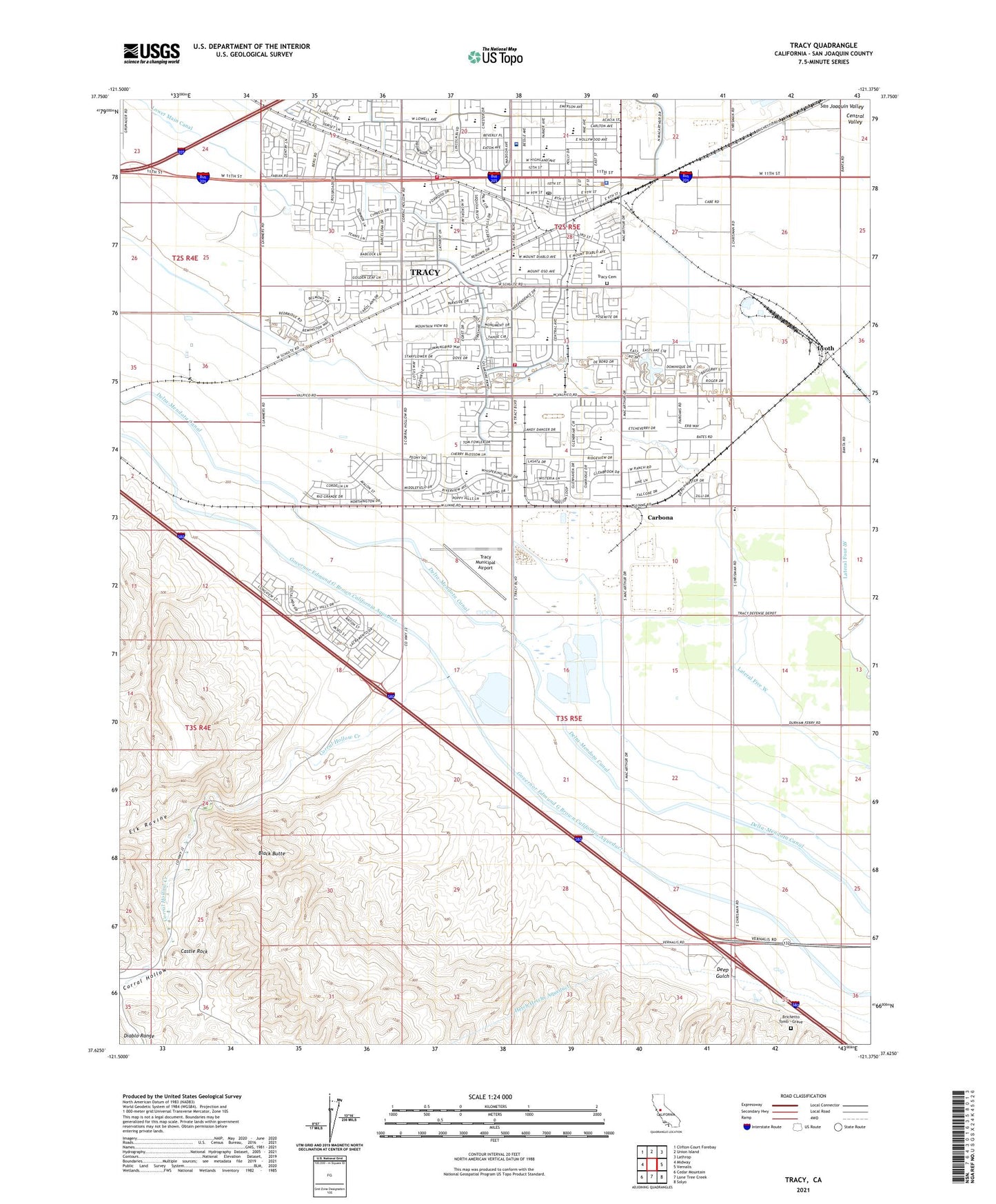
2021 topographic map quadrangle Tracy in the state of California. Scale: 1:24000. Based on the newly updated USGS 7.5' US Topo map series, this map is in the following counties: San Joaquin. The map contains contour data, water features, and other items you are used to seeing on USGS maps, but also has updated roads and other features. This is the next generation of topographic maps. Printed on high-quality waterproof paper with UV fade-resistant inks.
Quads adjacent to this one:
West: Midway
Northwest: Clifton Court Forebay
North: Union Island
Northeast: Lathrop
East: Vernalis
Southeast: Solyo
South: Lone Tree Creek
Southwest: Cedar Mountain
This map covers the same area as the classic USGS quad with code o37121f4.
Contains the following named places: Abundant Life Church, Alden Park, Bethlehem Church of God in Christ, Black Butte, Brichetto Tomb - Grave, Carbona, Castle Rock, Ceciliani Park, Celebration Christian Center, Central Elementary School, Church of Christ, Church of God in Christ, Church of the Nazarene, City of Tracy, Corral Hollow, Corral Hollow Creek, Deep Gulch, Defense distribution Depot - Tracy Site, Discovery Church, Earle E Williams Middle School, Elk Ravine, Ellis, Emma M Baumgardner Theatre, Evangelical Free Church of Tracy, Fabian Park, Faith Tabernacle United Pentecostal Church, Fine Park, First Baptist Church, First Presbyterian Church, First United Methodist Church, Gladys Poet Christian Elementary School, Grace Brethren Church, Grace Community Bible Church, H Alfred Clover Middle School, Harvest Park, Huck Park, Jefferson Elementary School, Jefferson School, Kelly Park, Kerlinger Pit, KHOP-FM (Modesto), Kingdom Hall of Jehovahs Witnesses, Kit Fox Park, KSGO-FM (Tracy), Lateral Five West, Lateral Four West, Lincoln Park, Lincoln West Plaza Shopping Center, Louis J Villalovoz Elementary School, Lyoth, MacDonald Park, McHenry House, McKinley Elementary School, Merrill F West High School, Monte Vista Middle School, Monticello School, Mount Diablo Park, Mount Oso Park, New Harvest Christian Center, Powers Park, Saint Bernards Roman Catholic Church, Saint Marks Episcopal Church, Saint Pauls Evangelical Lutheran Church, San Joaquin Depot Tracy, Sharpe General Depot, South Elementary School, South Public School, South School Park, Stevens Park, Sutter Tracy Community Hospital, Tracy, Tracy Adult School, Tracy Branch Stockton-San Joaquin County Public Library, Tracy Cemetery, Tracy Church of Christ, Tracy City Hall, Tracy Division, Tracy Fire Department Station 91, Tracy Fire Department Station 97, Tracy High School, Tracy Municipal Airport, Tracy Police Department, Tracy Post Office, True Vine Fellowship Church, Valley Community Baptist Church, Valley Oak Park, Wainwright Village, West Park Elementary School, ZIP Codes: 95304, 95376