MyTopo
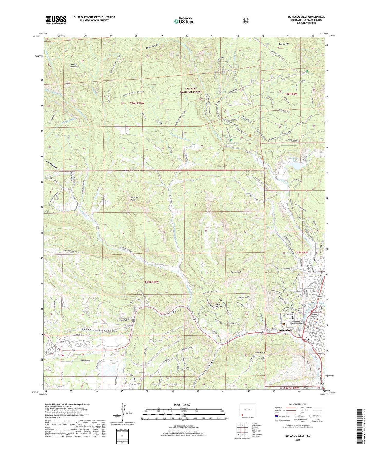
Durango West Colorado US Topo Map
Couldn't load pickup availability
Also explore the Durango West Forest Service Topo of this same quad for updated USFS data
2022 topographic map quadrangle Durango West in the state of Colorado. Scale: 1:24000. Based on the newly updated USGS 7.5' US Topo map series, this map is in the following counties: La Plata. The map contains contour data, water features, and other items you are used to seeing on USGS maps, but also has updated roads and other features. This is the next generation of topographic maps. Printed on high-quality waterproof paper with UV fade-resistant inks.
Quads adjacent to this one:
West: Hesperus
Northwest: La Plata
North: Monument Hill
Northeast: Hermosa
East: Durango East
Southeast: Loma Linda
South: Basin Mountain
Southwest: Kline
This map covers the same area as the classic USGS quad with code o37107c8.
Contains the following named places: Animas Overlook, Barnroof Point, Bay Coal Mine, Bell Quarry, Boston Mine, Buckley Park, C and F Coal Mine, Calvary Assembly of God Church, Castle Number Four Mine, Castle Number Two Mine, Centennial Center Shopping Center, Champion Gold Mine, Chapman Lake, Cherry Gulch, Church of Christ, City of Durango, Claire Viles Park, Coal Gulch, Coal Gulch Mine, College Plaza Shopping Center, Colorado State Patrol Troop 5A Durango, Columbine Pit, Davis Coal Mine, Deep Creek, Dry Fork Lightner Creek, Dry Gulch, Durango, Durango Big Picture High School, Durango Christian Church, Durango Fire and Rescue Authority Station 2 - Durango Fire Department, Durango Fire and Rescue Authority Station 9, Durango High School District, Durango Mall, Durango Medical Center, Durango Police Department, Durango Post Office, Durango Public Library, Durango-Silverton Narrow-Gauge Railroad, Emory E Smiley Junior High School, Ernest Canyon, Fassbinder Park, First Assembly of God Church, First Baptist Church, First Church of Christ Scientist, First Presbyterian Church, First Southern Baptist Church, Flicker Group Mine, Four Corners Healthcare Center, Gardenswartz Memorial Bridge, Gold Coin Mine, Graves Mine, Green Mountain Cemetery, Greenmount Cemetery, Hazel Mine Group, High Country Baptist Church, Hopkins Draw, Junction Creek Campground, KIQX-FM (Durango), KREZ-TV (Durango), KRSJ-FM (Durango), La Plata County Courthouse, Lady Maureen Mine, Lemon Pit, Lightner Creek, Lightner Creek Group Mine, Maine Mine, Mason Center, McCartney Group Mine, Mercy Manor, Miller Junior High School, Miller Middle School, Miller Mountain Mine, Morning Glory Mine, Morning Star Mine, Municipal Center Building, Murphy Mine, Needham School, Nevada Mine, Ohio-Indiana Mine, OK Mine, Park Elementary School, Peerless Mine, Perins Peak, Perins Peak State Wildlife Area, Pro Patria Tunnel Mine, Quinn Creek, Revenue Tunnel Mine, Rock Spring Draw, Roosa Park, Rotary Park, Sacred Heart Catholic Church, Saint Columba Catholic Church, Saint Columba Pre-School, Saint Marks Episcopal Church, Saint Paul Mine, Saint Pauls Lutheran Church, San Juan Mine, Sawmill Canyon, Schneider Park, Sheep Springs Gulch, Siegrist Pit, Smelter Mountain, South Fork Lightner Creek, Sunshine Mine, Thomas Property Mine, Town Plaza Shopping Center, Triangle Mine, Twin Buttes, Unitarian Fellowship Church, Victory Mine, Wildcat Canyon