MyTopo
Hinesville Georgia US Topo Map
Couldn't load pickup availability
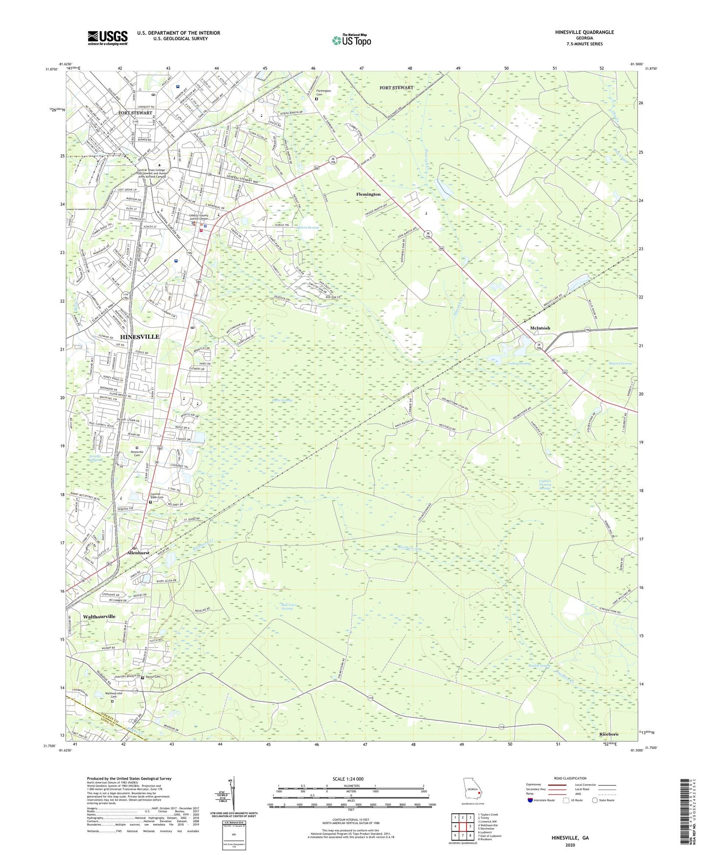
2024 topographic map quadrangle Hinesville in the state of Georgia. Scale: 1:24000. Based on the newly updated USGS 7.5' US Topo map series, this map is in the following counties: Liberty, Long. The map contains contour data, water features, and other items you are used to seeing on USGS maps, but also has updated roads and other features. This is the next generation of topographic maps. Printed on high-quality waterproof paper with UV fade-resistant inks.
Quads adjacent to this one:
West: Walthourville
Northwest: Taylors Creek
North: Trinity
Northeast: Limerick NW
East: Dorchester
Southeast: Riceboro
South: East of Ludowici
Southwest: Ludowici
This map covers the same area as the classic USGS quad with code o31081g5.
Contains the following named places: Allenhurst, Allenhurst Chapel, Allenhurst Post Office, Armstrong Atlantic State University, Ashmore, Bacon Cemetery, Bacon Church, Baconton Missionary Baptist Church, Bethel African Methodist Episcopal Church, Bowen, Bradwell Estates, Bradwell Institute, Brewton - Parker College Liberty Site, Button Gwinnett Elementary School, Captain Fleming Swamp, Cherokee Rose Country Club, Cherokee Village, Church of Christ, Cinder Hill, City of Allenhurst, City of Flemington, City of Hinesville, City of Walthourville, Country Lane Mobile Home Park, Country Manor Mobile Home Park, Cypress Slash Cemetery, Davis Swamp, Deer Run Estates, Deerwood Estates, Doe Run Estates, Doyles Mobile Home Park, Evergreen, First Calvary Baptist Church, First Presbyterian Church, First Presbyterian Church School, Flemington, Flemington Cemetery, Flemington Church, Fort Stewart, Fort Stewart Post Office, Frank Long Elementary School, Fraser Acres, Friendship Church, Full Gospel Tabernacle Church, Garden Acres, Garden Heights, Gills Island, Harrison Heights, Herbert Heights, Heritage Chapel, Hidden Pines, Hineshaw School, Hinesville, Hinesville Cemetery, Hinesville City Hall, Hinesville Fire Department Station 1, Hinesville First Baptist Church, Hinesville Korean Full Gospel Church, Hinesville Methodist Church, Hinesville Oxidation Pond, Hinesville Oxidation Pond Dam, Hinesville Police Department, Hinesville Post Office, Holmestown School, House of Refuge Church, Jordye Bacon Elementary School, Joseph Martin Elementary School, Korean United Methodist Church, Lancaster Estates, Lewis Frasier Middle School, Liberty Christian Fellowship Church, Liberty County Courthouse, Liberty County High School, Liberty County Sheriff's Office, Liberty Memorial Hospital Heliport, Liberty Regional Medical Center, Live Oak, Live Oak Public Library System Liberty Branch, Lyman Hall Elementary School, Marne Chapel, Martin Woods, Martins, McIntosh, Melvin Swamp, Mill Creek, Mosely Mobile Home Park, Mount Zion Church, New Home Society Cemetery, Northwest Woods, Olmstead, Palmer Siding, Pineview, Pinewood Estates, Pointe South, Richland School, Saint James Community Church, Saint Peters Church, Saint Philips Episcopal Church, Saint Stephen Catholic Church, Sancity Church, Sandy Run, Sandy Run School, Snelson - Golden Middle School, South Main Baptist Church, Taylors Creek Church, The Church of Jesus Christ of Latter Day Saints, Tupelo Trail, Victory Church, Walthourville Cemetery, Walthourville Church, Westside Baptist Christian School, WGML-AM (Hinesville), Wilderness Church, Wildwood, Williams Chapel, Winn Army Community Hospital, Woodwind South, WSKX-FM (Hinesville), Zion Temple, ZIP Codes: 31301, 31313