MyTopo
Hillsboro Illinois US Topo Map
Couldn't load pickup availability
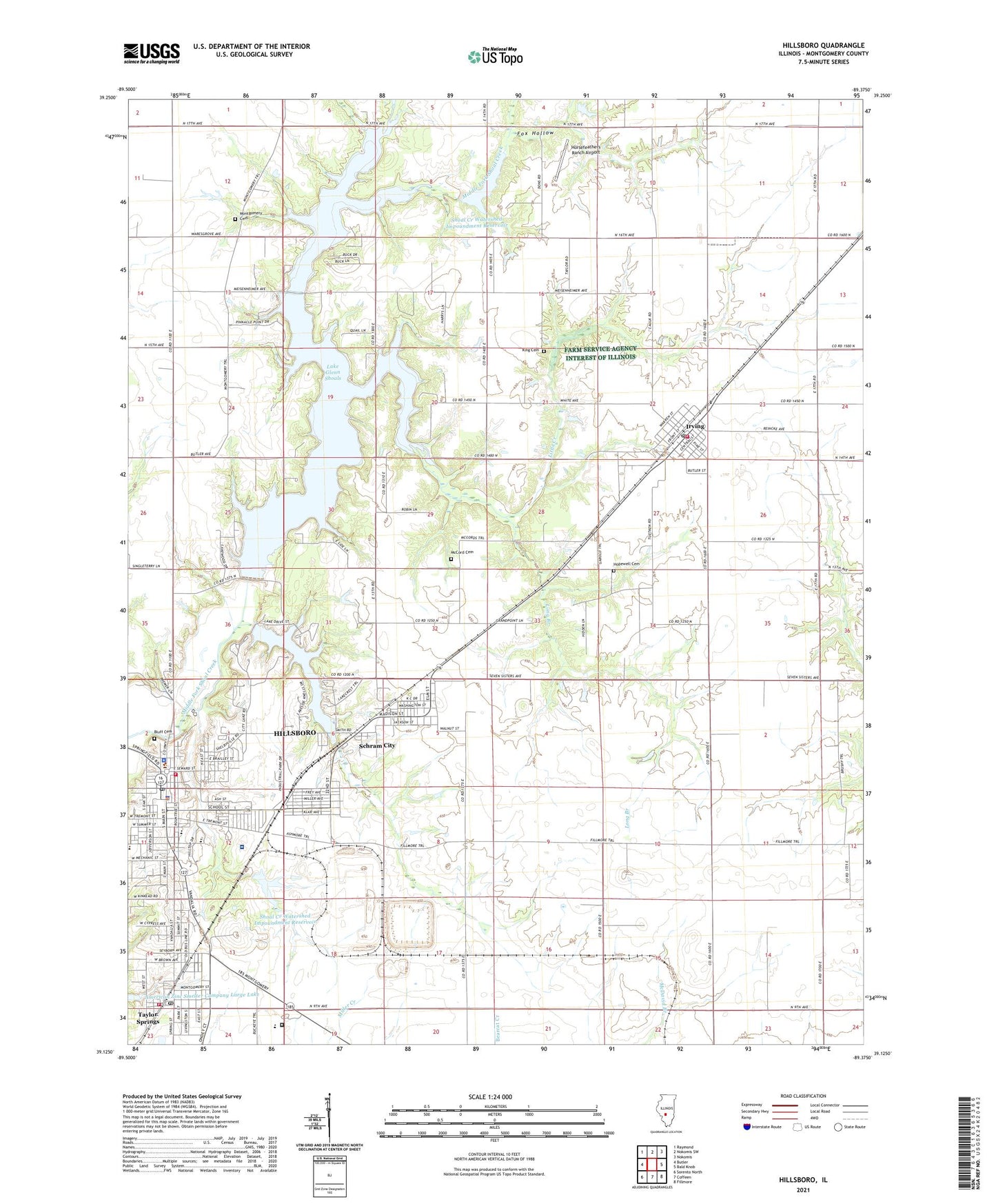
2024 topographic map quadrangle Hillsboro in the state of Illinois. Scale: 1:24000. Based on the newly updated USGS 7.5' US Topo map series, this map is in the following counties: Montgomery. The map contains contour data, water features, and other items you are used to seeing on USGS maps, but also has updated roads and other features. This is the next generation of topographic maps. Printed on high-quality waterproof paper with UV fade-resistant inks.
Quads adjacent to this one:
West: Butler
Northwest: Raymond
North: Nokomis SW
Northeast: Nokomis
East: Bald Knob
Southeast: Fillmore
South: Coffeen
Southwest: Sorento North
This map covers the same area as the classic USGS quad with code o39089b4.
Contains the following named places: Big Four Reservoir, Bluff Cemetery, Burbank Grade School, Calvary Baptist Church, Central Park, Challacombe Park, City of Hillsboro, Clear Springs School, Edison Public School, Fairmont Place, Fairview School, First Baptist Church, First Christian Church, First Methodist Church, First Pentecostal Church, First Presbyterian Church, Fox Hollow, Free Methodist Church, Gospel Tabernacle, Graham Correctional Center, Hillsboro, Hillsboro Ambulance Service, Hillsboro Area Hospital, Hillsboro City Hall, Hillsboro Country Club, Hillsboro Fire Department, Hillsboro Heights, Hillsboro High School, Hillsboro Hospital Heliport, Hillsboro Junior High School, Hillsboro Municipal Airport, Hillsboro Police Department, Hillsboro Post Office, Hillsboro Public Library, Hopewell Cemetery, Horsefeathers Ranch Airport, Irving, Irving Police Department, Irving Post Office, Irving Volunteer Fire Department, King Cemetery, Lake Glenn Shoals, Lake Hillsboro, Lake Hillsboro Dam, Little Creek, Long Branch, Ludewick School, McCord Cemetery, Meadowfield School, Montgomery Cemetery, Montgomery Church, Montgomery County, Montgomery County Courthouse, Montgomery County Sheriff's Office, Montgomery School, Osage School, Our Saviors Lutheran Church, Platt School, Saint Agnes Roman Catholic Church, Saint Agnes School, Saint James Baptist Church, Saint Pauls Evangelical Lutheran Church, Schram City, Schram City Public School, Shoal Creek Watershed Impoundment Reservoir, Shoal Creek Watershed Structure Number 14 Dam, Shoal Creek Watershed Structure Number 5 Dam, Sunnyside School, Sycamore School, Taylor School, Taylor Springs, Taylor Springs Post Office, Taylor Springs School, Taylor Springs Volunteer Fire Department, Township of Irving, Union School, Victor School, Village of Irving, Village of Schram City, Village of Taylor Springs, ZIP Codes: 62049, 62051, 62089