MyTopo
Columbus Indiana US Topo Map
Couldn't load pickup availability
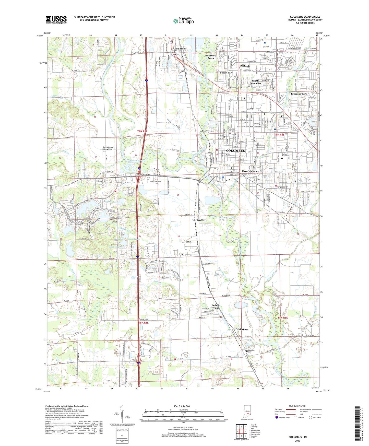
2022 topographic map quadrangle Columbus in the state of Indiana. Scale: 1:24000. Based on the newly updated USGS 7.5' US Topo map series, this map is in the following counties: Bartholomew. The map contains contour data, water features, and other items you are used to seeing on USGS maps, but also has updated roads and other features. This is the next generation of topographic maps. Printed on high-quality waterproof paper with UV fade-resistant inks.
Quads adjacent to this one:
West: New Bellsville
Northwest: Nineveh
North: Edinburgh
Northeast: Hope
East: Elizabethtown
Southeast: Azalia
South: Jonesville
Southwest: Waymansville
This map covers the same area as the classic USGS quad with code o39085b8.
Contains the following named places: 25th Street Shopping Center, 47201, Armuth Ditch, Asbury Church, Bartholomew County, Bartholomew County Hospital Airport, Berea Church, Bethel Village, Booth-Setser School, Carter Cemetery, Catherine Creek, Central Junior High School, City of Columbus, Clifty Creek, Clifty Creek Park, Columbus, Columbus Behavioral Health Center, Columbus City Cemetery, Columbus Fire Department Station 1, Columbus Fire Department Station 3, Columbus Fire Department Station 5, Columbus Fire Department Station 6, Columbus North High School, Columbus Police Department, Columbus Post Office, Columbus Regional Hospital, Columbus Regional Hospital Ambulance Service, Columbus Regional Hospital Ambulance Service Station 3, Columbus Shopping Center, Corn Brook, Crystal Lake, Daugherty Cemetery, Denios Creek, Donner Park, Driftwood River, East Columbus, East Columbus Church, East Columbus Independent Fire Department, East Columbus Independent Fire Department Station 221, East Columbus Independent Fire Department Station 222, Eastbrook Plaza, Everroad Park, Flatrock River, Forest Park, Garden City, Garfield School, Garland Brook Cemetery, Grace Church, Hansells Station, Haw Creek, Holiday Center Shopping Center, Jefferson Elementary School, Kent Elementary School, Lillian Schmitt Elementary School, Lincoln Elementary School, Lincoln Park, Long Lake, McDowell School, McKinley School, Mount Pleasant Cemetery, Mount Pleasant Church, North Columbus, Northside Elementary School, Opossum Creek, Parkside, Parkside Elementary School, Riverview Acres, Saint Bartholomews School, Saint Peter Lutheran School, Shireman Hog Farm, Stat Ambulance Service, State Street School, Strietelmeier Flying Field, Terrace Lake, Terrace Lake Dam, The International School of Columbus, Thompson Cemetery, Township of Columbus, Trans - Care Ambulance, Twin Lakes, Walesboro, Wayne Township Volunteer Fire Department, WCSI-AM (Columbus), WCSI-FM (Colombus), West Hill Shopping Center, Wolf Creek, Wood Lake, WWWY-FM (Columbus)