MyTopo
Spencer Iowa US Topo Map
Couldn't load pickup availability
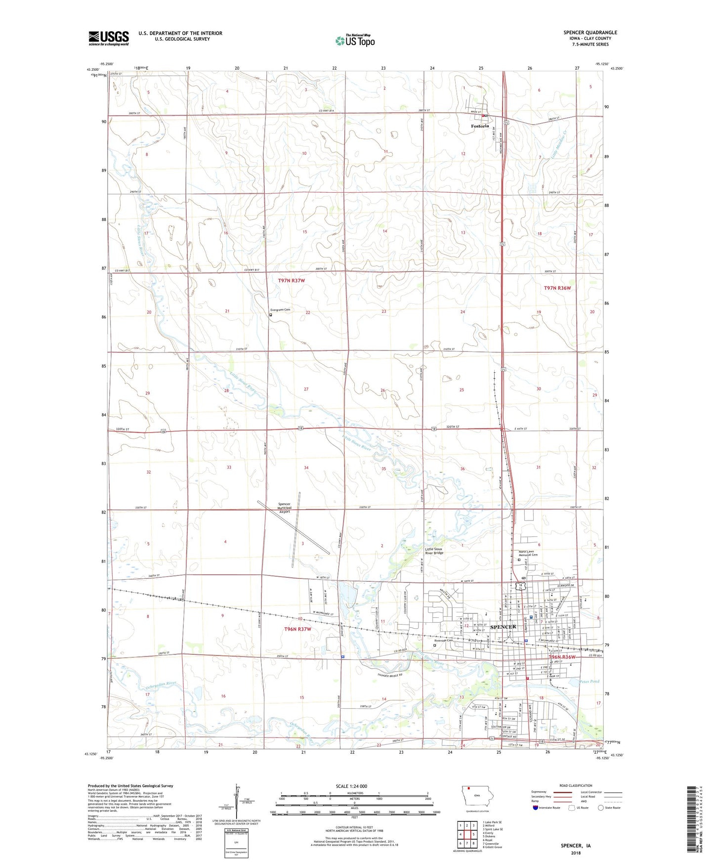
2022 topographic map quadrangle Spencer in the state of Iowa. Scale: 1:24000. Based on the newly updated USGS 7.5' US Topo map series, this map is in the following counties: Clay. The map contains contour data, water features, and other items you are used to seeing on USGS maps, but also has updated roads and other features. This is the next generation of topographic maps. Printed on high-quality waterproof paper with UV fade-resistant inks.
Quads adjacent to this one:
West: Everly
Northwest: Lake Park SE
North: Milford
Northeast: Spirit Lake SE
East: Dickens
Southeast: Gillett Grove
South: Greenville
Southwest: Royal
This map covers the same area as the classic USGS quad with code o43095b2.
Contains the following named places: Abben Cancer Center, Assembly of God Church, Bethany Lutheran Church, Birchwood Estates, Bob Howe - Thunder Bridge Wildlife Refuge, C Earl Page Park, Cardinal Field, Christ the King Lutheran Church, Church of the Nazarene, City of Fostoria, City of Spencer, Clay County Courthouse, Clay County Fairground, Clay County Jail, Clay County Law Library, Clay County Sheriff's Office, Cromwell Centre, East Leach Park, Evergreen Cemetery, Fairview Elementary School, Fairview Park, Family Dental Clinic, Farmers Co-op Elevator Company Elevator, First Baptist Church, First Christian Church, First Congregational Church, First English Lutheran Church, First Post Office Church School Historical Marker, Foot and Ankle Clinic, Fostoria, Fostoria City Hall, Fostoria Cooperative Elevator, Fostoria Fire and Rescue, Fostoria Post Office, Fox and Boyd Dental Center, Gateway North Shopping Center, Gaul Dermatology Center, Grace United Methodist Church, Harvest Evangelical Free Church, Hope Reformed Church, Iowa Eye Institute, Iowa Great Lakes Lutheran School, Jefferson Elementary School, Jehovahs Witnesses Kingdom Hall, Johnson Elementary School, KICD-AM (Spencer), KICD-FM (Spencer), Lincoln Elementary School, Little Sioux River Bridge, Living Word Church, Mercy Family Care Spencer Center - North, Mercy Family Care Spencer Center - South, Merten Farms, Miracle on Fourth Street Playground, Ninth Street Baptist Church, North Lawn Memorial Cemetery, North School, North School Park, Northwest Iowa Bone Joint and Sports Surgeons Center, Northwest Iowa Urologists Center, Ocheyedan River, Olberding Farms, Oral and Maxillofacial Surgery Center, Parker Historical Museum, Petes Pond, Rausch Farms, Reiter Wildlife Area, Reynolds Elementary School, Riverside Cemetery, Sacred Heart Catholic Church, Sacred Heart Catholic School, Saint Luke Lutheran Home, Seaman Farm, Seventh Day Adventist Church, Southpark Mall, Spencer, Spencer Campground, Spencer Chiropractic Clinic, Spencer Country Club, Spencer Dental Arts Center, Spencer Family Dental Center, Spencer Fire Department, Spencer High School, Spencer Hospital, Spencer Middle School, Spencer Municipal Airport, Spencer Municipal Hospital Heliport, Spencer Police Department, Spencer Post Office, Spencer Public Library, Spencer Recreation Trail, Stolley Gravel Pit Park, Stony Creek, Summit, Summit Post Office, Sunset Park, The Church of Jesus Christ of Latter Day Saints, Township of Summit, Trinity Lutheran Church, Twin Oaks Farm, United Pentecostal Church, Weiskircher Farms, Wells of Living Grace Church, West Leach Park, Westview Park, Yellowthroat Wildlife Area, ZIP Code: 51301