MyTopo
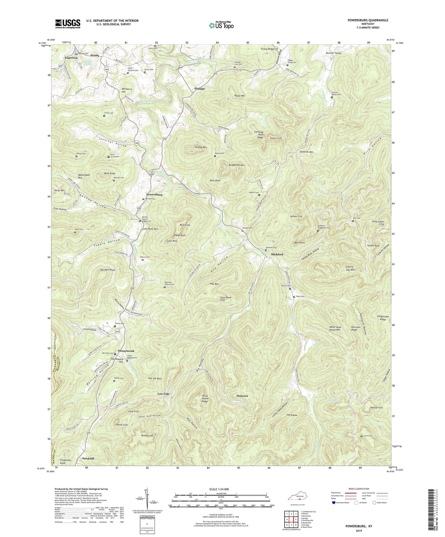
Powersburg Kentucky US Topo Map
Couldn't load pickup availability
2022 topographic map quadrangle Powersburg in the state of Kentucky. Scale: 1:24000. Based on the newly updated USGS 7.5' US Topo map series, this map is in the following counties: Wayne, Clinton. The map contains contour data, water features, and other items you are used to seeing on USGS maps, but also has updated roads and other features. This is the next generation of topographic maps. Printed on high-quality waterproof paper with UV fade-resistant inks.
Quads adjacent to this one:
West: Savage
Northwest: Cumberland City
North: Parnell
Northeast: Monticello
East: Parmleysville
Southeast: Sharp Place
South: Pall Mall
Southwest: Moodyville
This map covers the same area as the classic USGS quad with code o36084f8.
Contains the following named places: Bearpen Hollow, Bens Cliff, Bertram Cemetery, Bertram Hollow, Bills Bluff, Bridgeman Mountain, Browns Mill, Buck Graveyard, Buck Knob, Bucks Cemetery, Burris Cemetery, Carey Cemetery, Carpenter Fork, Catron Cemetery, Catron Hollow, Charley Bridgeman Mill, Cherry Gap Mountain, Chestnut Grove School, Chestnut Grove United Baptist Church, Chimney Rock Ridge, Covey Cemetery, Dalton Cemetery, Denney Cemetery, Denney Hollow, Denney Hollow School, Denver-Hoover-Tuggle Cemetery, Devils Kitchen, Dishman Cemetery, Dishman Mill, Double Head Creek, Doublehead Springs, Dry Hollow, Dry Hollow School, Duncan Valley Cemetery, Duncan Valley School, Edwards Chapel, Edwards Mountain, Fitzgerald Knob, Frost Hollow, Gap Creek Mill, Gap Creek School, Gap Creek Spring, Gapcreek, Gapcreek Post Office, Gingercake Ridge, Goff Mill, Guffey Mountain, Gum Pond, Gum Pond Cliff, Hall Hollow, Hancock School, Harmon Hollow, Harrison Ridge, Hicks Mountain, Hicks-Harmon Cemetery, Hidalgo, Hidalgo Post Office, Hidalgo School, Hog Hollow, Hog Mountain, Hog Rock, Horse Cliff, Horse Pound Ridge, Horse Rock, Huffaker-Bridgeman Cemetery, Indian Graveyard, Indian Rockhouse, Jennings Hollow, Jennings Hollow School, Jimtown, Keens Chapel, Kelsay Cemetery, King Green Cliff, Lee Mill, Lone Rock, Lone Rock Mountain, Lonerock Post Office, Long Cliff, Low Gap, Lowe Cemetery, Lucky Camp Hollow, Manning Peercy Cemetery, Massengale Mountain, Mill Point, Mitchell Knob, Morgan Cemetery, Mose Point, Mountain View Baptist Camp, Mullberry Hill, Oil Well Hole, Peercy Cemetery, Peercy Hollow, Perdue Cemetery, Pleasant Hill Church, Powersburg, Powersburg Elementary School, Powersburg Post Office, Pyles Cemetery, Raines Cemetery, Rains Cemetery, Redmond Creek, Reuben Dishman Mill, Rice Cemetery, Round Cliff, Sand Springs, Sandy Valley School, Scotts Cliff, Sheep Rock, Sidwell Cemetery, Slickford, Slickford Post Office, Slickford School, Slobaum Well, Stinson-Coil Cemetery, Sunnybrook, Sunnybrook Post Office, Sunnybrook School, Sweet Gum Hollow, Taylor Grove Church, Taylor Mountain, Teacup Cliff, The Elbow, The Howard Hill, The Joe Rock, Tuggle Hollow, Tuggle-Young Cemetery, Turkey Ridge School, Turkey Rock, Turkey Rock Hollow, Union Baptist Cemetery, Upchurch Hollow, Water Rock House Mountain, Whitson Mill, Winding Gap, Windy, Windy High School, Windy Post Office, Yellow Cliff, Zula-Powersburg Division