MyTopo
Parnell Kentucky US Topo Map
Couldn't load pickup availability
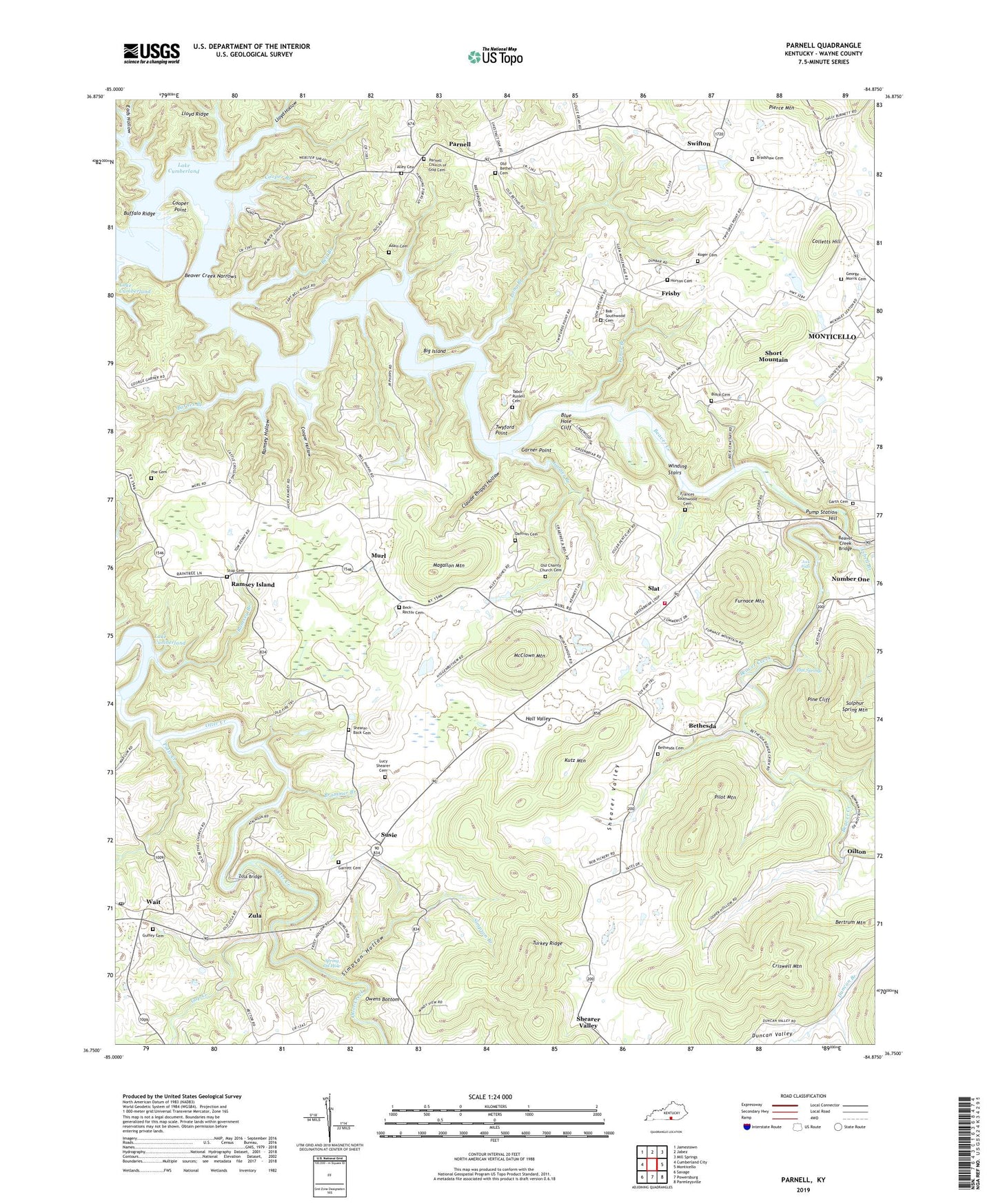
2022 topographic map quadrangle Parnell in the state of Kentucky. Scale: 1:24000. Based on the newly updated USGS 7.5' US Topo map series, this map is in the following counties: Wayne. The map contains contour data, water features, and other items you are used to seeing on USGS maps, but also has updated roads and other features. This is the next generation of topographic maps. Printed on high-quality waterproof paper with UV fade-resistant inks.
Quads adjacent to this one:
West: Cumberland City
Northwest: Jamestown
North: Jabez
Northeast: Mill Springs
East: Monticello
Southeast: Parmleysville
South: Powersburg
Southwest: Savage
This map covers the same area as the classic USGS quad with code o36084g8.
Contains the following named places: Adair Cemetery, Alex Post Office, Alley Cemetery, Alpha Post Office, Ards Ford, Backbone School, Barnes Branch, Barnes Normal School, Beaver Creek Bridge, Beaver Creek Narrows, Beaver Lodge, Beaver Lodge Dock, Beck-Rector Cemetery, Bell Branch, Bertrum Mountain, Bethesda, Bethesda Cemetery, Bethesda Methodist Church, Bethesda Post Office, Bethesda School, Big Island, Black Cemetery, Blue Hole Cliff, Bob Southwood Cemetery, Bone Cave, Bradshaw Cemetery, Brammer Branch, Browns Mill, Buffalo Ridge, Carter Dock, Central Union Church, Claude Phipps Hollow, Colletts Hill, Cooper Branch, Cooper Hollow, Cooper Point, Criswell Mountain, Daffron Cemetery, Ditch Mill, Dug Ford, Eads Hollow, Elk Spring Creek, Flat Springs, Flat Springs Post Office, Francis Southwood Cemetery, Frisby, Frisby Post Office, Furnace Mountain, Gap Creek, Garner Branch, Garner Point, Garrett Cemetery, George Morris Cemetery, Guffey Cemetery, Guffey Chapel, Hall Valley, Hall Valley School, Hanging Rock, Happy Top, Highway Church, Highway Holiness Church, Horton Cemetery, Isbell Branch, Isbell Cemetery, Jock Falls, Jock Rankin Mill, Joshua Jones Furnace, Kelsay Mills, Koger Cemetery, Kutz Mountain, Lloyd Hollow, Lloyd Ridge, Long Branch, Lucy Shearer Cemetery, Lynch Ford, Magallon Mountain, McClown Mountain, Monticello Pumping Station, Mount Union Church of Christ, Murl, Murl Post Office, Murl School, New Bethel Church, New Charity Baptist Church, Oilton, Oilton Post Office, Old Bethel Bible Church, Old Bethel Cemetery, Old Charity Cemetery, Old Charity Church, Ollie Branch, Owens Bottom, Paisley Post Office, Parnell, Parnell Church, Parnell Church of God Cemetery, Parnell Post Office, Parnell School, Pierce Mountain, Pilot Mountain, Pine Cliff, Poe Cemetery, Potts Creek, Pump Station Hill, Rabbit Patch, Ramsey Branch, Ramsey Hollow, Ramsey Island, Rectors Flat Church, Rodes Garth Cemetery, Shearer Valley, Shearer Valley Church of Christ, Shearer Valley Post Office, Shearer Valley School, Shearer-Back Cemetery, Shindig, Short Mountain, Simpson Branch, Simpson Hollow, Slat, Slat Post Office, Spring Oil Hole, Stop, Stop Cemetery, Stop Post Office, Susie, Susie Fire Department, Susie Post Office, Swifton, Swifton Post Office, Tabor Branch, Tabor-Russell Cemetery, Turkey Ridge, Turkey Ridge Post Office, Twyford Point, Wait, Wait Post Office, Wait School, Winding Stairs, Zion Church, Zula, Zula Bridge, Zula Mill, Zula Post Office