MyTopo
Columbia Louisiana US Topo Map
Couldn't load pickup availability
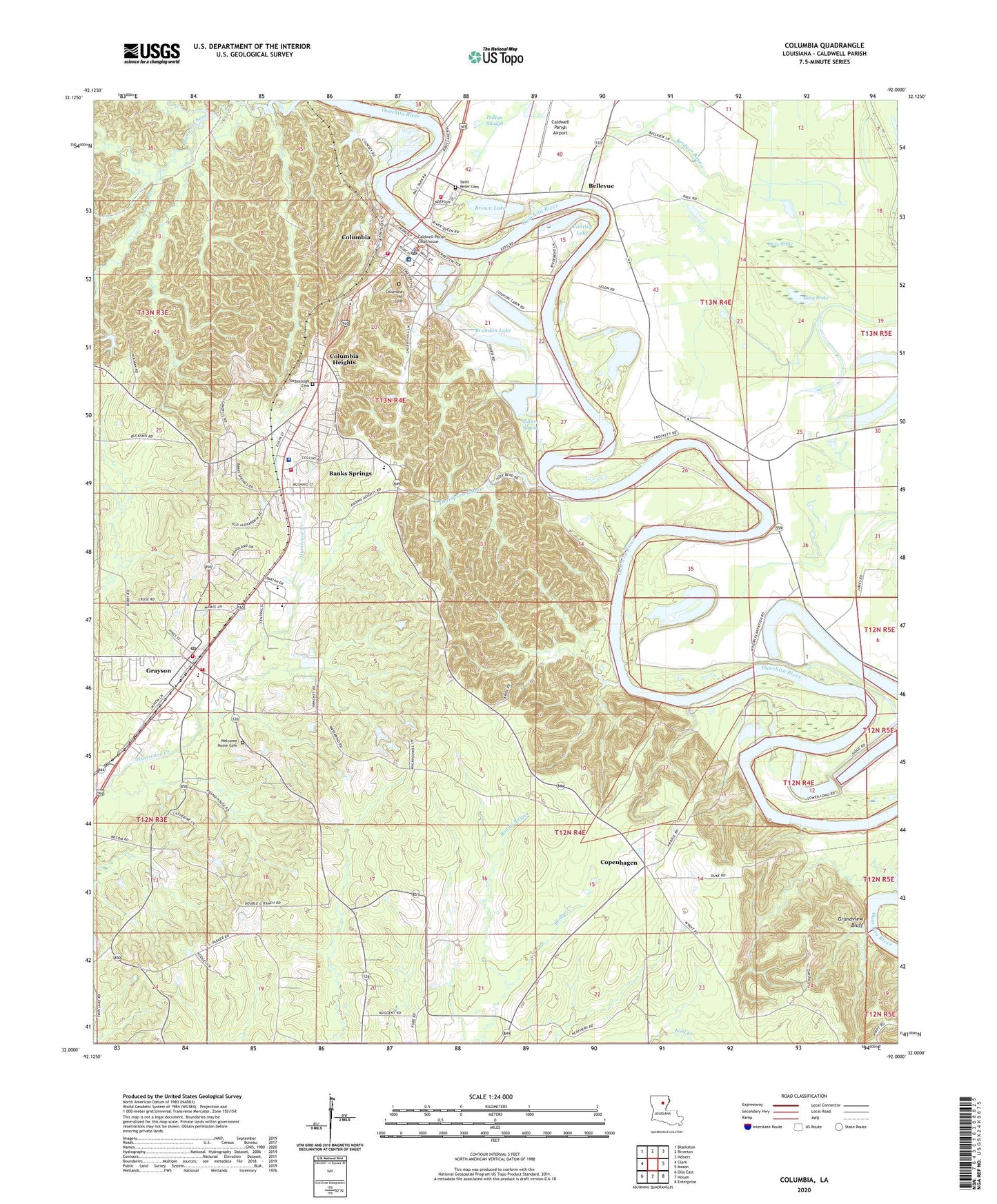
2024 topographic map quadrangle Columbia in the state of Louisiana. Scale: 1:24000. Based on the newly updated USGS 7.5' US Topo map series, this map is in the following counties: Caldwell. The map contains contour data, water features, and other items you are used to seeing on USGS maps, but also has updated roads and other features. This is the next generation of topographic maps. Printed on high-quality waterproof paper with UV fade-resistant inks.
Quads adjacent to this one:
West: Clark
Northwest: Blankston
North: Riverton
Northeast: Hebert
East: Mason
Southeast: Enterprise
South: Holum
Southwest: Olla East
This map covers the same area as the classic USGS quad with code o32092a1.
Contains the following named places: Banks Springs, Banks Springs Census Designated Place, Bellevue, Bellevue Landing, Boggy Bayou, Brandon Lake, Bridger Bayou, Brown Lake, Bunker Hill Landing, Caldwell Church, Caldwell Memorial Hospital, Caldwell Parish, Caldwell Parish High School, Caldwell Parish Junior High School, Caldwell Parish Preschool, Caldwell Parish Sheriff's Office, Citizens Medical Center, Columbia, Columbia Developmental Center, Columbia Elementary School, Columbia Heights, Columbia Heights Baptist Church, Columbia Heights Volunteer Fire Department, Columbia Hil Cemetery, Columbia Post Office, Columbia Volunteer Fire Department, Copenhagen, Copenhagen Gas Field, Copenhagen Landing, Copenhagen Prairie, Dixon Lake, Dizzy Brake, First Baptist Church of Columbia, First United Methodist Church, Gibson Landing, Gin Rake Landing, Grandview Bluff, Grayson, Grayson Baptist Church, Grayson Elementary School, Grayson Methodist Church, Grayson Volunteer Fire Department, Grayson Volunteer Fire Department Station 2, Heison Landing, Hogan Landing, Home Landing, Humble Lake, Humble Lake Gas Field, Jacks Landing, John Higgins Landing, John Hough Landing, John Sillars Landing, KCTO-AM (Columbia), Linden Landing, Long Lake, Long Lake Gas Field, Lower Long Lake, Mindenhall Landing, Mount Pleasant Church, Old Ferry Landing, Parish Governing Authority District 4, Pinder Landing, Pulpwood Spur, Saint Pauls Baptist Church, Saint Peter Cemetery, Shiloh Methodist Church, Sillars Bayou, South Grayson Gas Field, Squires Landing, Stock Landing, T J Brown Landing, Thompson Bayou, Thompson Brake, Town of Columbia, Union Central Elementary School, Vantley Lake, Village of Grayson, Wade Landing, Ward Eight, Ward Five, Ward Four, Ward Three, Welcome Home Cemetery, Welcome Home Gas Field, Wood Landing, Yarborough Cemetery