MyTopo
Big Rapids Michigan US Topo Map
Couldn't load pickup availability
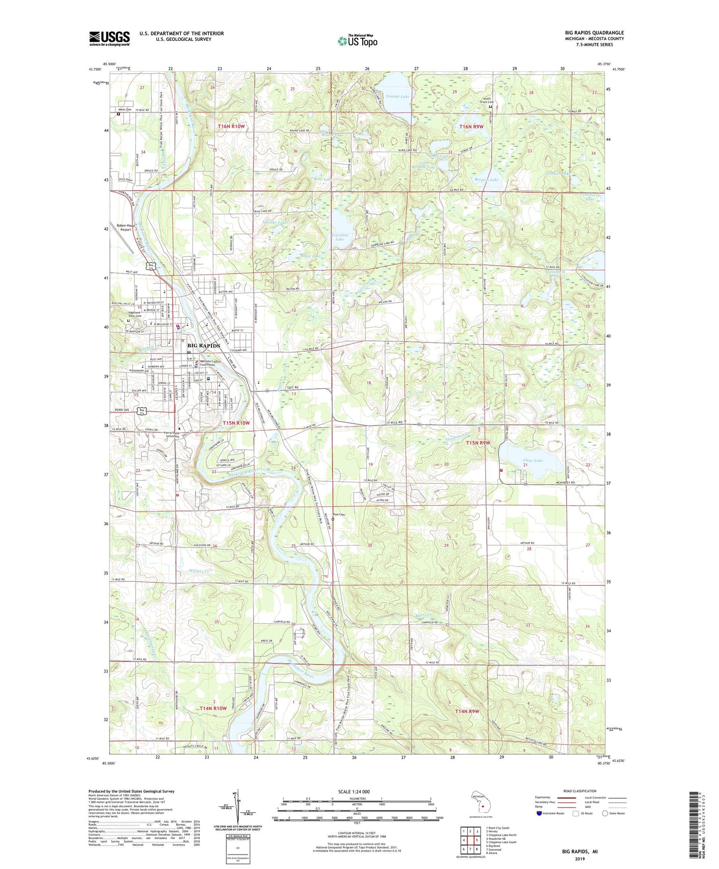
2023 topographic map quadrangle Big Rapids in the state of Michigan. Scale: 1:24000. Based on the newly updated USGS 7.5' US Topo map series, this map is in the following counties: Mecosta. The map contains contour data, water features, and other items you are used to seeing on USGS maps, but also has updated roads and other features. This is the next generation of topographic maps. Printed on high-quality waterproof paper with UV fade-resistant inks.
Quads adjacent to this one:
West: Woodville NE
Northwest: Reed City South
North: Hersey
Northeast: Chippewa Lake North
East: Chippewa Lake South
Southeast: Altona
South: Stanwood
Southwest: Big Bend
This map covers the same area as the classic USGS quad with code o43085f4.
Contains the following named places: Alma Lake, Alumni Building, Arts and Sciences Commons, Ashegun Lake, Automotive Center, Bergess Lake, Big Rapids, Big Rapids Assembly of God Church, Big Rapids Church of Christ, Big Rapids Department of Public Safety Fire Station, Big Rapids Free Methodist Church, Big Rapids Library, Big Rapids Middle School, Big Rapids Mobile Home Court, Big Rapids Parish, Big Rapids Police Department, Big Rapids Post Office, Big Rapids Station, Big Rapids Township Fire Department, Birkam Health Center, Bishop Hall, Bond Hall, Brookside Elementary School, Brookside School, Brophy Hall, Business Building, Byers Creek, Byers Post Office, Byers Station, Carlisle Hall, Centennial Park, Central Valley Community Church, Church of Jesus Christ of Latter Day Saints, Church of the Nazarene, Circle Drive Mobile Home Park, City of Big Rapids, Clark Hall, Clear Lake, Colfax Township Fire Department, College Park Mobile Village, Cramer Hall, Creative Arts Center, Crossroads Charter Academy, Dalziel Creek, Division Street Post Office, East Campus Apartments, Eastwood Elementary School, Ely School, Evangelical Wesleyan Church, Ewigleben Sports Complex, Fairman Community Pool, Falcon Head Golf Club, Fellowship Christian Reformed Church, Ferris Institute Historical Marker, Ferris State College Historical Marker, Ferris State University, Ferris State University Department of Public Safety, First Baptist Church, First United Methodist Church, First United Methodist Church Historical Marker, Flite Library, Forest Hills Mobile Home Park, Fred Meijer White Pine Trail State Park, General Services Building, Gooseneck Pond, Granger Center, Hallisy Hall, Hanchett Park, Heavy Equipment Technology, Helen Ferris Hall, Hemlock Park, Henderson Hall, Higginson Creek, Highland View Cemetery, Hillcrest Elementary School, Hillcrest School, Holland Park, Hunt Lake, Immanuel Lutheran Church, Industrial Park Ballfield, Instructional Resource Center, Johnson Hall, Knollcrest Commons, Library Park, Lincoln School, Linden Street Park, Little Bergess Lake, Marshfield Post Office, Masselink Hall, McKessey House, McNerney Hall, Meceola Country Club, Mecosta County Building, Mecosta County Emergency Medical Services, Mecosta County General Hospital Heliport, Mecosta County Historical Museum, Mecosta County Sheriff's Office, Mecosta/Osceola Intermediate School District-Campus, Merrill Hall, Miller Hall, Mineral Well Historical Marker, Mitchell Creek, Mitchell Creek Park, Music Building, National Elastomer Center, Nehmer Lake, Northend Riverside Park, Old Mecosta County Jail Historical Marker, Osceola Pavillion, Pharmacy Building, Pickell Hall, Pine Plains Cemetery, Pleasant View School, Pocket Park, Power House, Prakken Building, Puterbaugh Hall, Rankin Student Center, Redeemer Lutheran Church, Reorganized Church of Jesus Christ, River Street Park, Riverview Elementary School, Rose Lake, Round Lake, Ryan Creek, Saint Andrew's Episcopal Church, Saint Andrew's Episcopal Church Historical Marker, Saint Mary's Catholic Church, Saint Mary's Catholic School, Saint Paul Catholic Campus Parish, Saint Peter's Lutheran Church, Saint Peter's Lutheran School, Science Building, Seventh-Day Adventist Church, South Campus Apartments, South Commons, South Grant Cemetery, Southwest Commons, Southwest Heating Plant, Spectrum Health Big Rapids Hospital, Starr Building, State Street Church of God, Student Recreational Center, Supervisors Park, Swan Building, Swede Hill Park, Taggart Hall, Third Avenue United Methodist Church, Timme Center for Student Services, Top Taggart Field, Townline Lake, Township of Colfax, Travis Hall, United Church of Big Rapids, Vandercook Hall, Victor F Spathelf Center, Vogel Field, Ward Hall, WBRN-AM (Big Rapids), WBRN-FM (Big Rapids), West Building, West Campus Apartments, West Cemetery, West Commons, West Intramural Fields, Williams Auditorium, Winters Creek, Youngs Lake, ZIP Code: 49307