MyTopo
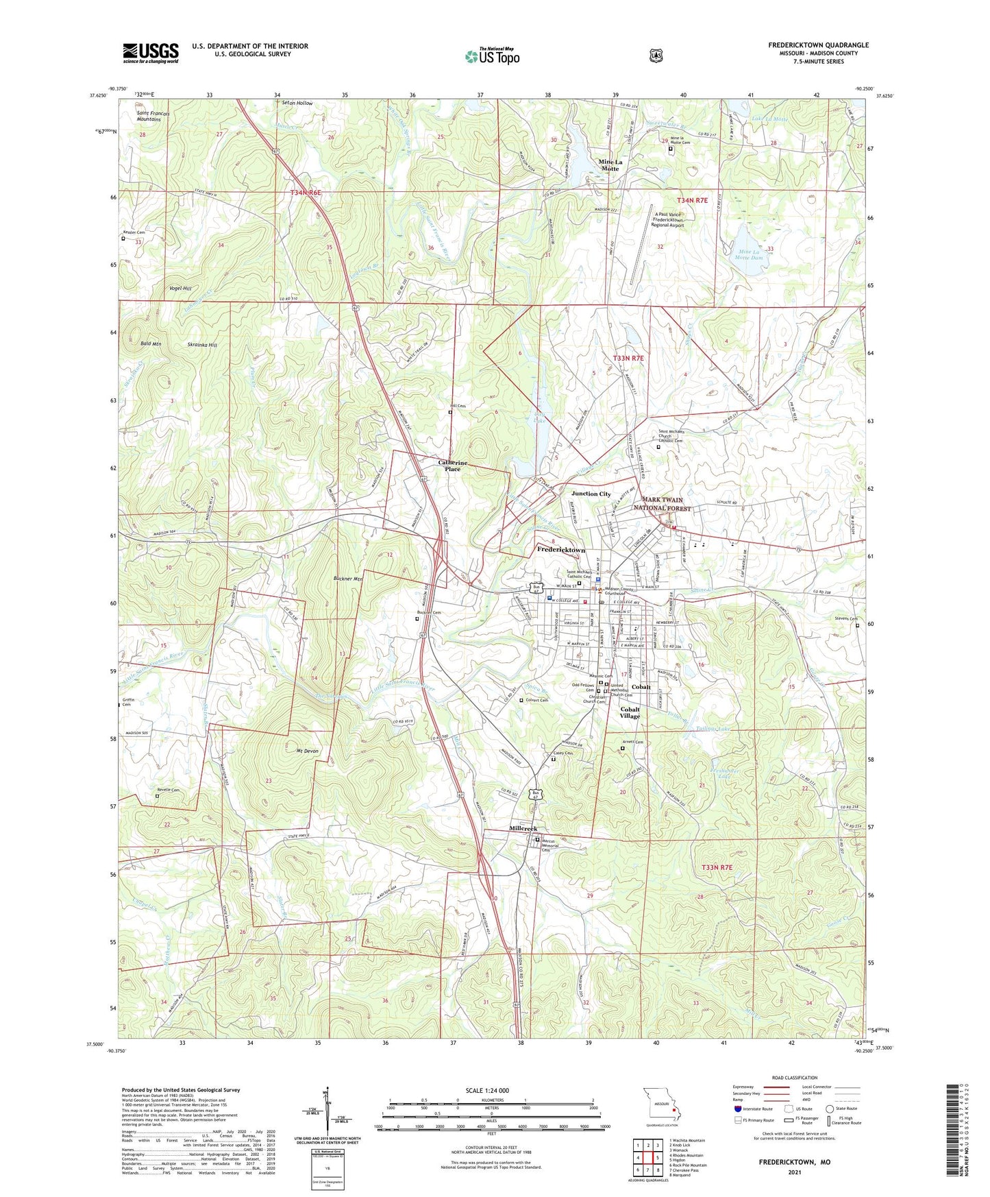
Fredericktown Missouri US Topo Map
Couldn't load pickup availability
Also explore the Fredericktown Forest Service Topo of this same quad for updated USFS data
2021 topographic map quadrangle Fredericktown in the state of Missouri. Scale: 1:24000. Based on the newly updated USGS 7.5' US Topo map series, this map is in the following counties: Madison. The map contains contour data, water features, and other items you are used to seeing on USGS maps, but also has updated roads and other features. This is the next generation of topographic maps. Printed on high-quality waterproof paper with UV fade-resistant inks.
Quads adjacent to this one:
West: Rhodes Mountain
Northwest: Wachita Mountain
North: Knob Lick
Northeast: Womack
East: Higdon
Southeast: Marquand
South: Cherokee Pass
Southwest: Rock Pile Mountain
This map covers the same area as the classic USGS quad with code o37090e3.
Contains the following named places: A Paul Vance Fredericktown Regional Airport, Arnett Cemetery, Bald Mountain, Boswell School, Buckner Cemetery, Buckner Mountain, Burns School, Casey Cemetery, Catherine Mines, Catherine Place, Catherine School, Cedar Grove School, Cherokee Pass Volunteer Fire Department Station 2, City Lake, City Lake Park, City of Fredericktown, Cobalt Village, Colvert Cemetery, Copper Mine School, Copper Mines Church, Flowing Well, Fredericktown, Fredericktown City Dam, Fredericktown Country Club, Fredericktown District Ranger Station, Fredericktown Fire Department, Fredericktown Post Office, Freshwater Lake, Goose Creek, Hill Cemetery, John Bollinger Number 1 Dam, John Bollinger Number 2 Dam, Junction City, Kessler Cemetery, KFTW-AM (Fredericktown), Lahmeyer Creek, Lake Harmony Dam, Lake La Motte, Lindsey Mine, Logtown Branch, Madison County Sheriff's Office, Madison Medical Center, Madison Memorial Heliport, Main Tailings Dam - Anschutz, Marcus Memorial Cemetery, Mark Twain National Forest Potosi Fredericktown Ranger District Frederickstown Office, Matthew Creek, Matthews Creek, Mill Creek, Millcreek, Mine La Motte, Mine la Motte Cemetery, Mine La Motte Census Designated Place, Mine La Motte Church, Mine La Motte Dam, Mine La Motte Lake, Missouri Department of Conservation Forestry Southeast Regional Field Fire Office Fredericktown, Mount Devon, Musco Creek, Offset Mine, Old Jack Mine, Park City Mines, Plum Creek, Revelle Cemetery, Saint Joseph Lead Mines, Saint Michaels Catholic Cemetery, Saint Michaels Church, Saint Michaels Church Catholic Cemetery, Saint Michaels School, Saline Creek, Schulte Mine, Shady Grove Church, Shady Grove School, Shays Creek, Skrainka Hill, Slater Branch, Slime Pond, Slime Pond Dam, Spiva Branch, Stevens Cemetery, Sweetwater Branch, Tailings Lake, The Narrows, Thompson Ford, Tollar Branch, Township of Mine La Motte, Township of Saint Michael, Twin Oak Church, Upstream Dam, Village Creek, Village Creek School, Village of Cobalt, Village of Junction City, Vogel Hill, White Oak Springs Branch, ZIP Code: 63645