MyTopo
Bad Luck Creek Montana US Topo Map
Couldn't load pickup availability
Also explore the Bad Luck Creek Forest Service Topo of this same quad for updated USFS data
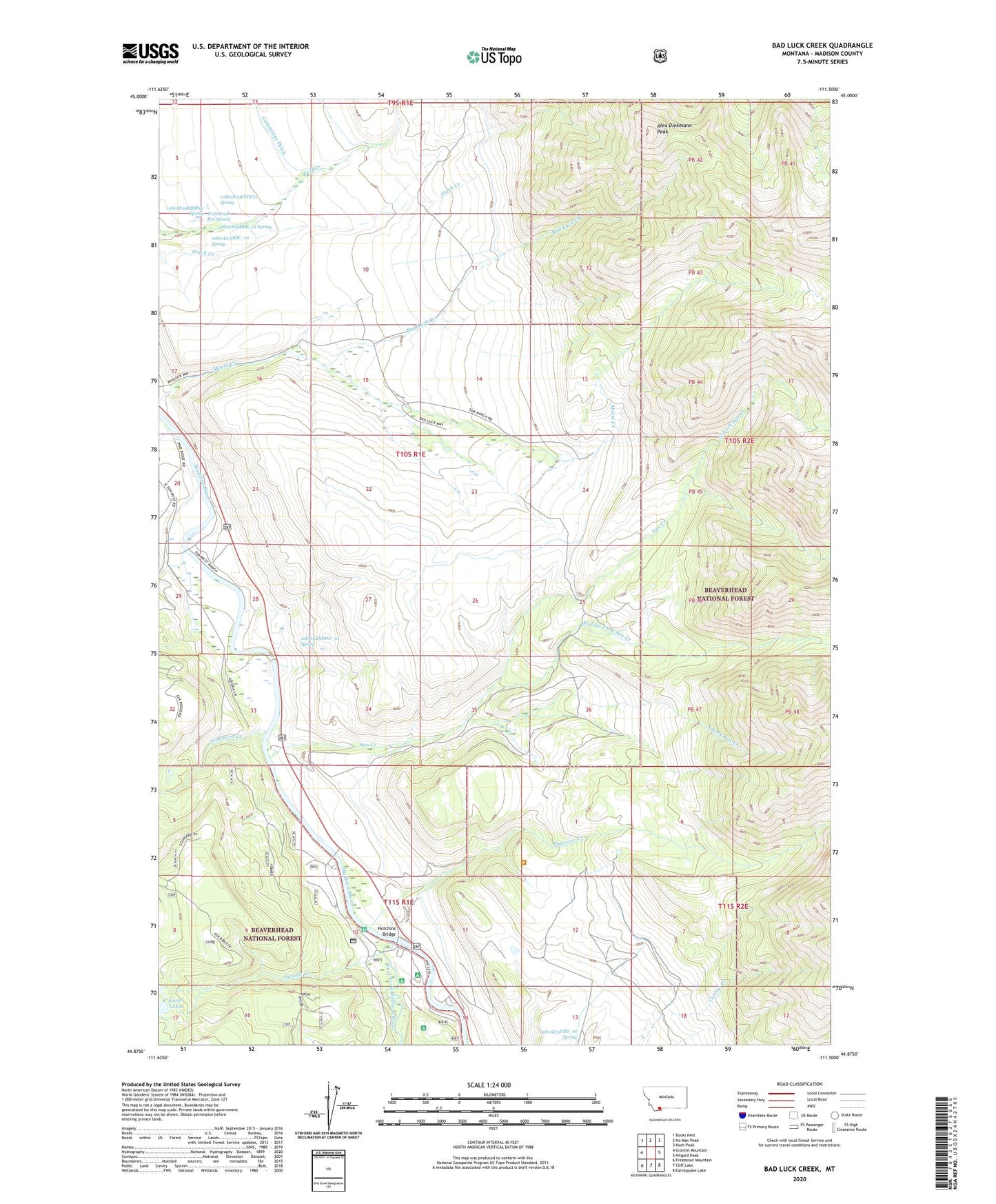
2024 topographic map quadrangle Bad Luck Creek in the state of Montana. Scale: 1:24000. Based on the newly updated USGS 7.5' US Topo map series, this map is in the following counties: Madison. The map contains contour data, water features, and other items you are used to seeing on USGS maps, but also has updated roads and other features. This is the next generation of topographic maps. Printed on high-quality waterproof paper with UV fade-resistant inks.
Quads adjacent to this one:
West: Granite Mountain
Northwest: Bucks Nest
North: No Man Peak
Northeast: Koch Peak
East: Hilgard Peak
Southeast: Earthquake Lake
South: Cliff Lake
Southwest: Freezeout Mountain
Contains the following named places: 10S01E04CCCC01 Spring, 10S01E09BBB_01 Spring, 10S01E09BBBB01 Spring, 10S01E09BBC_01 Spring, 10S01E15DDAD01 Well, 10S01E17DAB_01 Well, 10S01E17DAB_02 Well, 10S01E21CCDD01 Well, 10S01E28DDD_01 Spring, 10S01E33DDB_01 Well, 11S01E03CACB01 Well, 11S01E03CCCB01 Well, 11S01E10DACD01 Well, 11S01E13DBB_01 Spring, 11S01E14BABD01 Well, Alex Diekmann Peak, Bad Luck Creek, Gazelle Creek, Horse Creek, Hutchins Bridge, Hutchins Ranch, Kirby Ranch, Lyon Forest Service Station, Lyon Post Office, Lyon School, Lyons Bridge Fishing Access Site, Madison Campground, Middle Fork Sun Creek, North Fork Sun Creek, Papoose Creek, Papoose Ditch, Quaking Aspen Creek, Raynolds Pass Historical Marker, Secret Lakes, Snowhall Inn, South Fork Sun Creek, Squaw Creek Ranch, Standard Creek, Sun Creek, Sun Ranch, United States Forest Service Lyon Work Camp, United States Forest Service West Fork Camp, West Fork Cabins and RV Park, West Fork Campground, West Fork Cow Camp, West Fork Madison River, West Fork Rest Area, Wolf Creek Hot Spring