MyTopo
Drummond Montana US Topo Map
Couldn't load pickup availability
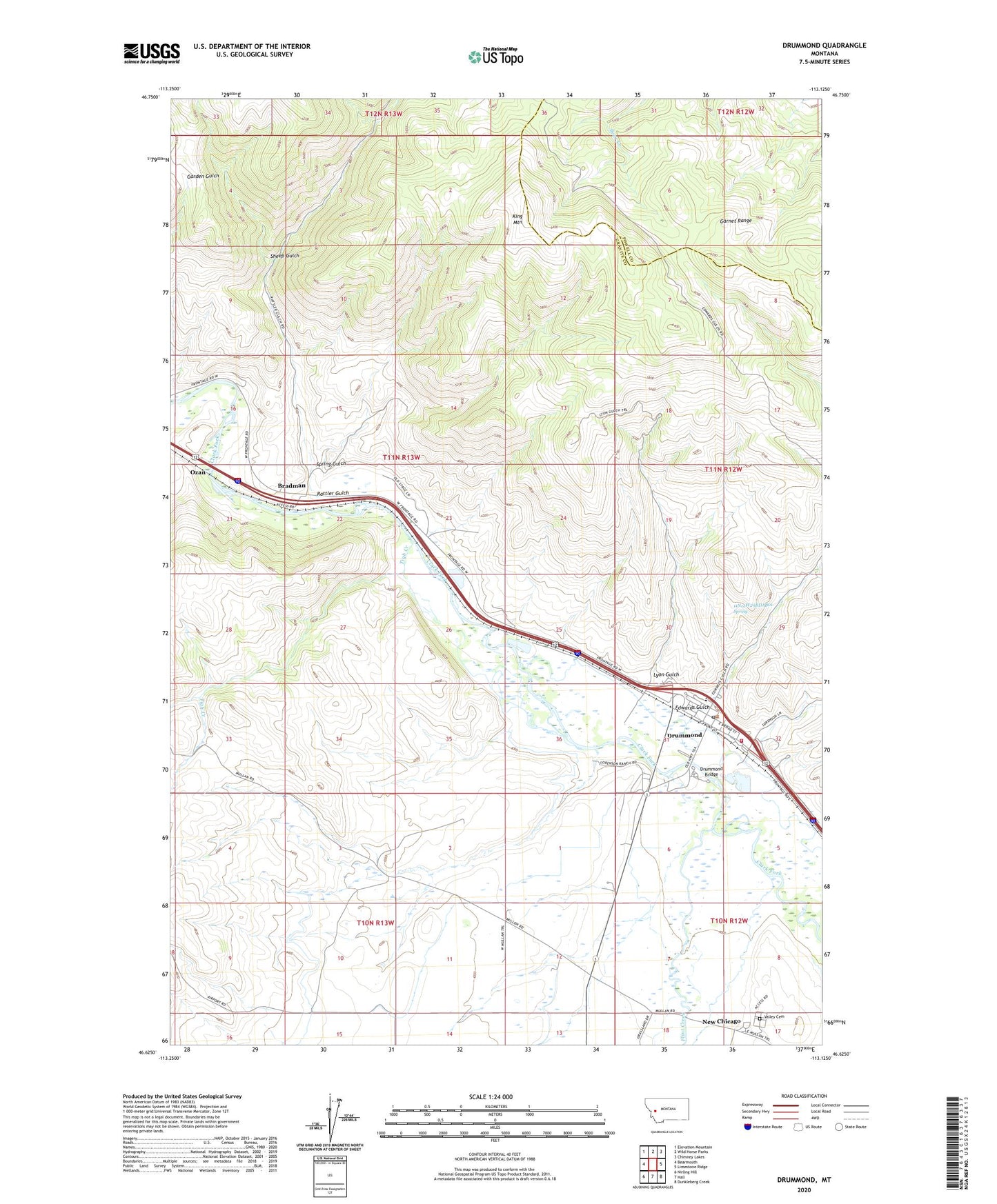
2024 topographic map quadrangle Drummond in the state of Montana. Scale: 1:24000. Based on the newly updated USGS 7.5' US Topo map series, this map is in the following counties: Granite, Powell. The map contains contour data, water features, and other items you are used to seeing on USGS maps, but also has updated roads and other features. This is the next generation of topographic maps. Printed on high-quality waterproof paper with UV fade-resistant inks.
Quads adjacent to this one:
West: Bearmouth
Northwest: Elevation Mountain
North: Wild Horse Parks
Northeast: Chimney Lakes
East: Limestone Ridge
Southeast: Dunkleberg Creek
South: Hall
Southwest: Nirling Hill
This map covers the same area as the classic USGS quad with code o46113f2.
Contains the following named places: 10N12W06BAAA01 Well, 10N12W06BBAA01 Well, 10N12W06CBBC01 Well, 10N12W17BABB01 Well, 10N12W17BBDB01 Well, 10N13W12BDDA01 Well, 11N12W29BDAA01 Well, 11N12W29BDAB01 Spring, 11N12W29CCCC01 Well, 11N12W30CDDD01 Well, 11N12W31AAAA01 Well, 11N12W31AAAD01 Well, 11N12W31AACA01 Well, 11N12W31AACB01 Well, 11N12W31AACB02 Well, 11N12W31AACC01 Well, 11N12W31AACC02 Well, 11N12W31AACD01 Well, 11N12W31AACD02 Well, 11N12W31AACD03 Well, 11N12W31AACD04 Well, 11N12W31AACD05 Well, 11N12W31AADD01 Well, 11N12W31ABAC01 Well, 11N12W31ABAD01 Well, 11N12W31ABCD01 Well, 11N12W31ABDA01 Well, 11N12W31ABDA02 Well, 11N12W31ABDA03 Well, 11N12W31ADAA01 Well, 11N12W31ADAA02 Well, 11N12W31ADAB01 Well, 11N12W31ADAB02 Well, 11N12W31ADAD01 Well, 11N12W31ADAD02 Well, 11N12W31ADAD03 Well, 11N12W31ADBA01 Well, 11N12W31ADBB01 Well, 11N12W31ADBD01 Well, 11N12W31ADBD02 Well, 11N12W31ADDA01 Well, 11N12W31CCAC01 Well, 11N12W31CCAD01 Well, 11N12W31CCDA01 Well, 11N12W31CDAB01 Well, 11N12W31CDAD01 Well, 11N12W31CDBA01 Well, 11N12W31CDBC01 Well, 11N12W31CDBC02 Well, 11N12W31CDBC03 Well, 11N12W31CDCB01 Well, 11N12W31CDDA01 Well, 11N12W31DABA01 Well, 11N12W31DABA02 Well, 11N12W31DABC01 Well, 11N12W31DABC02 Well, 11N12W31DBDA01 Well, 11N12W31DCAD01 Well, 11N12W32BCBC01 Well, 11N12W32BCBC02 Well, 11N12W32BCCD01 Well, 11N12W32CBAA01 Well, 11N13W16ABCC01 Well, 11N13W22AAAC01 Well, 11N13W23CDBA01 Well, 11N13W23CDDA01 Well, 11N13W26AACC01 Well, 11N13W36DDBA01 Well, 11N13W36DDBA02 Well, Bradman, Community Health Nurse, Drummond, Drummond Bridge, Drummond Community Church, Drummond Museum, Drummond Post Office, Drummond Public Library, Drummond Public Schools, Drummond Volunteer Ambulance, Edwards Gulch, Flint Creek, Hoffmans, King Mountain, Lyon Gulch, New Chicago, New Chicago Post Office, New Chicago School, Ozan, Rattler Gulch, Saint Michael Parish, Sheep Gulch, Spring Gulch, The Church of Jesus Christ of Latter Day Saints, Tigh Creek, Town of Drummond, Valley Cemetery, Valley Rural Fire Department