MyTopo
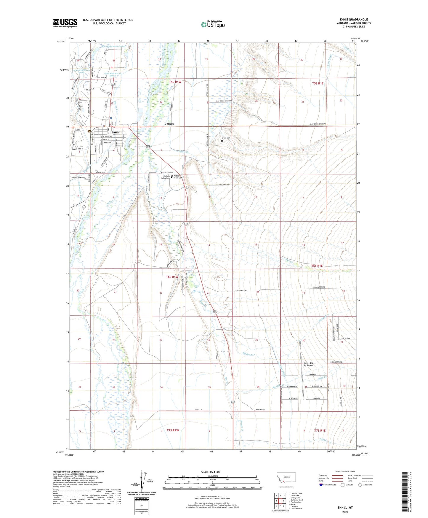
Ennis Montana US Topo Map
Couldn't load pickup availability
Also explore the Ennis Forest Service Topo of this same quad for updated USFS data
2024 topographic map quadrangle Ennis in the state of Montana. Scale: 1:24000. Based on the newly updated USGS 7.5' US Topo map series, this map is in the following counties: Madison. The map contains contour data, water features, and other items you are used to seeing on USGS maps, but also has updated roads and other features. This is the next generation of topographic maps. Printed on high-quality waterproof paper with UV fade-resistant inks.
Quads adjacent to this one:
West: Eightmile Creek
Northwest: Leonard Creek
North: Ennis Lake
Northeast: Cherry Lake
East: Fan Mountain
Southeast: Lake Cameron
South: Cameron
Southwest: Varney
This map covers the same area as the classic USGS quad with code o45111c6.
Contains the following named places: 05S01E32ACCB01 Well, 05S01W28ACBA01 Well, 05S01W28ACBC01 Well, 05S01W28ACDD01 Well, 05S01W28ADBA01 Spring, 05S01W28BCBD01 Well, 05S01W28CABD01 Well, 05S01W28DABC01 Well, 05S01W28DABC02 Well, 05S01W28DBC_01 Well, 05S01W28DBCB01 Well, 05S01W28DBCB02 Well, 05S01W28DBD_01 Well, 05S01W28DBDD01 Well, 05S01W28DCA_01 Spring, 05S01W28DCBA01 Well, 05S01W28DCBB01 Well, 05S01W28DCCA01 Well, 05S01W28DCCB01 Well, 05S01W28DCD_01 Spring, 05S01W28DDBC01 Well, 05S01W33ABDB01 Well, 05S01W33BADB01 Well, 05S01W33BBAA01 Well, 05S01W33BBAA02 Well, 05S01W33BBCC01 Well, 05S01W33CBCB01 Well, 05S01W33CDBD01 Well, 06S01E31CAAC01 Well, 06S01W02CBCB01 Well, 06S01W03AABA01 Well, 06S01W03ABAB01 Well, 06S01W03ABAC01 Well, 06S01W03CDAD01 Well, 06S01W03DAAA01 Well, 06S01W04AABB01 Well, 06S01W04ACCB01 Well, 06S01W04BCAD01 Well, 06S01W04CCDB01 Well, 06S01W05AAAA01 Well, 06S01W05AABD01 Well, 06S01W05ACBD01 Well, 06S01W08DABD01 Well, 06S01W09BBCA01 Well, 06S01W10ABAC01 Well, 06S01W10BAAA01 Well, 06S01W23BBAC01 Well, 06S01W23BBBA01 Well, 06S01W34DDDA01 Well, 06S01W35DAAB01 Well, 07S01W03CAB_01 Well, 59729, Assembly of God Church, Bear Creek, Bear Creek Ditch, Boulder Creek, Burger Creek, Burnt Tree Fishing Access Site, Camper Corner, Cedar Creek Alluvial Fan, Charging Bear Indian Museum and Trading Post, Eightmile Creek, Elkhorn Store and RV Park, Ennis, Ennis Big Sky Airport, Ennis Fire Department, Ennis Fishing Access Site, Ennis High School, Ennis Lake Community Park, Ennis Police Department, Ennis Post Office, Ennis Recreation Site, Ennis Rodeo Grounds, Ennis School, Ennis Volunteer Ambulance Service, Evans Cemetery, Farrell Post Office, Farrelton School, Jeffers, Jeffers Census Designated Place, Jeffers Post Office, Jeffers School, Madison County Nursing Home, Madison Meadows Golf Course, Madison Ranger Station, Madison Valley Baptist Church, Madison Valley Cemetery, Madison Valley Clinic, Madison Valley Medical Center, Madison Valley Public Library, Madison Valley Rural Fire Department Station 1, McDeed Creek, O'Dell Creek, Rocky Mountain Antler Museum, Rocky Mountain Baptist Church, Saint Patrick Catholic Church, Shell Creek, Shepherd of the Hills Lutheran Church, Sportsmans Field, The Church of Jesus Christ of Latter Day Saints, Tolman Creek, Town of Ennis, Trinity Episcopal Church, Valley Garden Fishing Access Site, Valley Garden Recreation Site, Wildlife Museum of the West