MyTopo
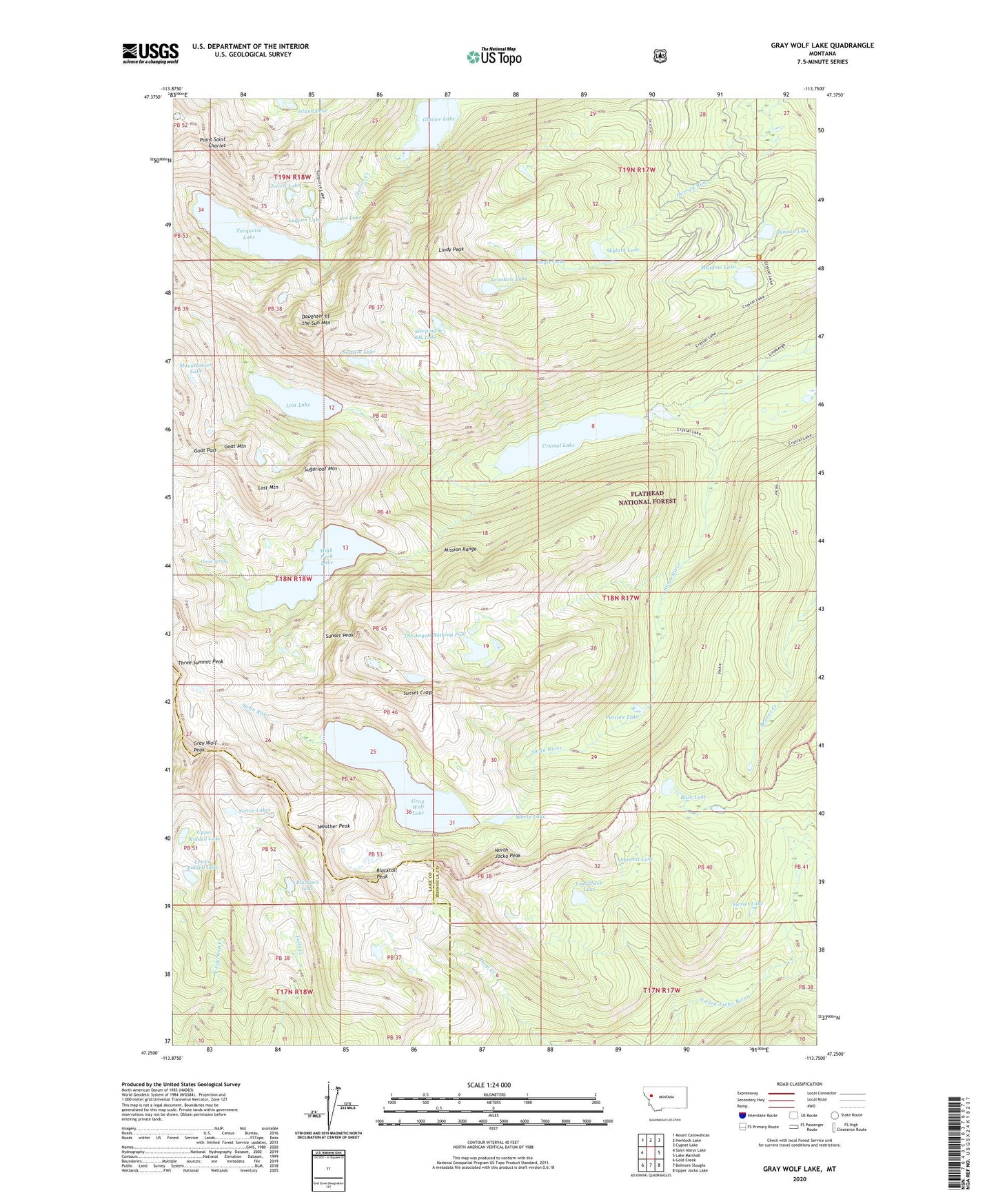
Gray Wolf Lake Montana US Topo Map
Couldn't load pickup availability
Also explore the Gray Wolf Lake Forest Service Topo of this same quad for updated USFS data
2024 topographic map quadrangle Gray Wolf Lake in the state of Montana. Scale: 1:24000. Based on the newly updated USGS 7.5' US Topo map series, this map is in the following counties: Missoula, Lake. The map contains contour data, water features, and other items you are used to seeing on USGS maps, but also has updated roads and other features. This is the next generation of topographic maps. Printed on high-quality waterproof paper with UV fade-resistant inks.
Quads adjacent to this one:
West: Saint Marys Lake
Northwest: Mount Calowahcan
North: Hemlock Lake
Northeast: Cygnet Lake
East: Lake Marshall
Southeast: Upper Jocko Lake
South: Belmore Sloughs
Southwest: Gold Creek
This map covers the same area as the classic USGS quad with code o47113c7.
Contains the following named places: Beanhole Lake, Blacktail Lake, Blacktail Peak, Buck Lake, Bunyan Lake, Crystal Lake, Daughter of the Sun Mountain, Eagle Lake, Giant Spring, Glacier Lake, Goat Mountain, Goat Pass, Gray Wolf Glacier, Gray Wolf Lake, Gray Wolf Peak, High Park Lake, Jewell Lake, Lace Lake, Lagoon Lake, Lindy Peak, Lost Lake, Lost Mountain, Lost Sheep Lake, Lower Riddell Lake, Meadow Lake, Mountaineer Lake, North Jocko Peak, Pass of the Winds, Pasture Lake, Point Saint Charles, Scenic Lakes, Seepela Lake, Skylark Lake, Sleeping Elk Lake, Sugarloaf Mountain, Summit Lake, Sunset Crags, Sunset Lake, Sunset Peak, The Angels Bathing Pool, Three Summit Peak, Turquoise Lake, Upper Riddell Lake, Weather Peak, Whelp Lake, ZIP Code: 59826