MyTopo
High Point East North Carolina US Topo Map
Couldn't load pickup availability
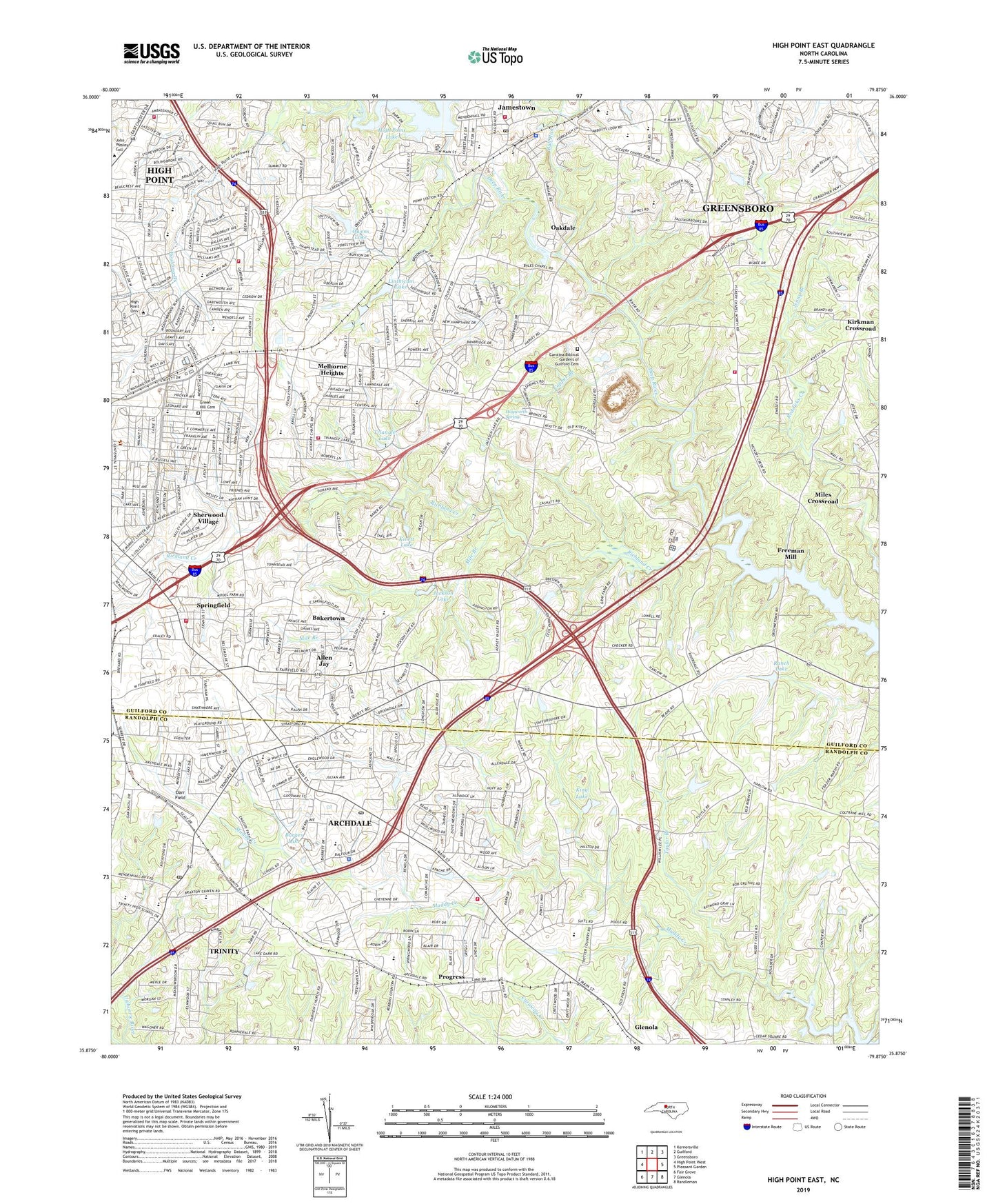
2022 topographic map quadrangle High Point East in the state of North Carolina. Scale: 1:24000. Based on the newly updated USGS 7.5' US Topo map series, this map is in the following counties: Guilford, Randolph. The map contains contour data, water features, and other items you are used to seeing on USGS maps, but also has updated roads and other features. This is the next generation of topographic maps. Printed on high-quality waterproof paper with UV fade-resistant inks.
Quads adjacent to this one:
West: High Point West
Northwest: Kernersville
North: Guilford
Northeast: Greensboro
East: Pleasant Garden
Southeast: Randleman
South: Glenola
Southwest: Fair Grove
This map covers the same area as the classic USGS quad with code o35079h8.
Contains the following named places: Allen Jay, Allen Jay Middle School, Allen Jay Park, Archdale, Archdale Elementary School, Archdale Police Department, Archdale Post Office, Archdale-Trinity Middle School, Bakertown, Bales Church, Boulding Branch, Braxton Craven Elementary School, Brentwood Elementary School, Brentwood Park, Bull Run, Burges Lake, Burges Lake Dam, Carolina Biblical Gardens of Guilford Cemetery, Cedron Park, City of Archdale, City of High Point, Copper Branch, Darr Field, Deep River Tabernacle, Eastwood Park, Ebenezer Church, Emma Blair Elementary School, Fairfield Church, Five Points Park, Freeman Mill, Friendly Church, Green Hill Cemetery, Guil - Rand Fire Department Station 20, Guilford County Sheriff's Office - District 3, Hayworth Spring, Hickory Chapel, High Point College East Campus, High Point Fire Department Station 13, High Point Fire Department Station 6, High Point Fire Department Station 7, High Point Fire Department Station 9, High Point Municipal Dam, High Point Sewage Disposal, High Point University, Jackson Lake, Jamestown, Jamestown Elementary School, Jamestown Middle School, Jamestown Post Office, Jamestown Quarry, Jamestown Quarry Dam, Jamestown Quarry Lake, Jenny Branch, King Lake, King Lake Dam, Kirkman Crossroad, Kivett Lake, Leonard Street School, Linthicum Lake, Linthicum Lake Dam, Lucy Ragsdale Senior High School, McCain Park, Melborne Heights, Mile Branch, Miles Crossroad, Millis Road Elementary School, Mitchel Grove Church, Oak Grove Church, Oakdale, Oakdale Church, Owens Lake, Owens Lake Dam, Park View School, Piedmont Triad Ambulance and Rescue, Pine Grove Church, Pinecroft - Sedgefield Fire District Station 22, Pinecroft - Sedgefield Fire District Station 46, Progress, Providence Church, Ranch Lake, Ranch Lake Dam, Randolph Church, Ravenwood, Richland Creek, Robins Nest, Roxana, Sherwood Village, Springfield, Stones Throw, T W Andrews High School, Taylor Branch, Thompson Lake Dam, Town of Jamestown, Township of High Point, Township of Jamestown, Triangle Lake, Trindale School, Trinity, Trinity Elementary School, Trinity High School, Trinity Park, Trinity Post Office, Trinity School, Union Hill School, Vickrey Church, Washington Terrace Park, West Fork Deep River, Westwood, William Penn High School, WWIH-FM (High Point), ZIP Codes: 27260, 27263, 27282