MyTopo
Highlands North Carolina US Topo Map
Couldn't load pickup availability
Also explore the Highlands Forest Service Topo of this same quad for updated USFS data
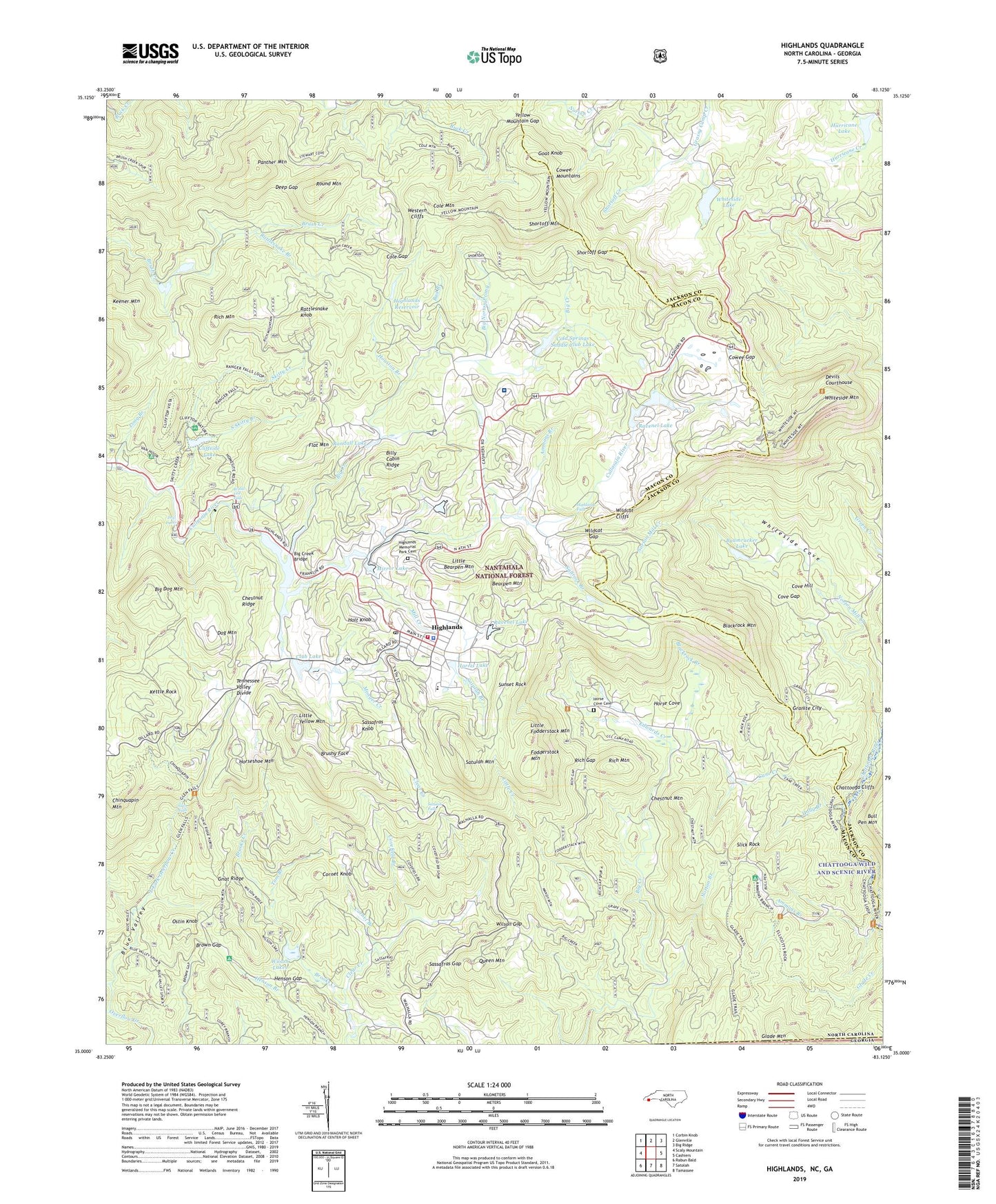
2022 topographic map quadrangle Highlands in the state of North Carolina. Scale: 1:24000. Based on the newly updated USGS 7.5' US Topo map series, this map is in the following counties: Macon, Jackson, Rabun. The map contains contour data, water features, and other items you are used to seeing on USGS maps, but also has updated roads and other features. This is the next generation of topographic maps. Printed on high-quality waterproof paper with UV fade-resistant inks.
Quads adjacent to this one:
West: Scaly Mountain
Northwest: Corbin Knob
North: Glenville
Northeast: Big Ridge
East: Cashiers
Southeast: Tamassee
South: Satolah
Southwest: Rabun Bald
This map covers the same area as the classic USGS quad with code o35083a2.
Contains the following named places: Ammons Branch, Ammons Branch Campground, Bad Branch, Baumrucker Dam, Baumrucker Lake, Bearpen Mountain, Big Creek, Big Creek Bridge, Big Dog Mountain, Big Norton Prong, Billy Cabin Ridge, Blackrock Branch, Blackrock Mountain, Blue Valley, Blue Valley Campground, Blue Valley Experimental Forest, Bridal Veil Falls, Brooks Creek, Brown Gap, Brushy Face, Cane Creek, Chestnut Mountain, Chestnut Ridge, Chinquapin Mountain, Clear Creek Church, Clear Creek School, Cliffside Dam, Cliffside Lake, Cliffside Lake Recreation Site, Club Lake, Cold Springs Saddle Club Dam, Cold Springs Saddle Club Lake, Cole Gap, Cole Mountain, Cornet Branch, Cornet Knob, Cove Gap, Cove Hill, Covefield Branch, Cowee Gap, Deep Gap, Devils Courthouse, Dog Mountain, Dry Falls, East Fork Overflow Creek, Edwards Creek, Ellicott Rock Trail, Flat Mountain, Fodderstack Mountain, Glen Falls, Gnat Ridge, Goat Knob, Granite City, Harris Lake, Henson Gap, Highlands, Highlands Cashiers Hospital, Highlands Country Club, Highlands Falls, Highlands Fire and Rescue Station, Highlands Memorial Park Cemetery, Highlands Police Department, Highlands Post Office, Highlands Rescue Squad, Highlands Reservoir, Holly Branch, Holt Knob, Horse Cove, Horse Cove Cemetery, Horseshoe Mountain, Houston Branch, Hurricane Lake, Keener Mountain, Kettle Rock, Lake Sequoyah, Little Bearpen Mountain, Little Creek, Little Fodderstack Mountain, Little Yellow Mountain, Long Branch, Mill Creek, Mirror Lake, Mirror Lake Dam, Monger Creek, Norton Branch, Norton Mill Creek, Ostin Knob, Panther Mountain, Queen Mountain, Randall Lake, Rattlesnake Branch, Rattlesnake Knob, Ravenel Lake, Ravenel Lake Dam, Rich Gap, Rich Mountain, Richard Wood Lower Dam, Richard Wood Lower Lake, Richard Wood Upper Dam, Richard Wood Upper Lake, Round Mountain, Saltrock Branch, Sassafras Gap, Sassafras Knob, Satulah Branch, Satulah Falls, Satulah Mountain, Sequoyah Dam, Shortoff Church, Shortoff Creek, Shortoff Gap, Shortoff Mountain, Shortoff Mountain Trail, Skitty Creek, Slick Rock, South Skitty Branch, Sunset Rock, Tom Branch, Town of Highlands, Township of Highlands, Vanhook Glade Campground, Vanhook Wayside Park, West Fork Overflow Creek, Western Cliffs, Whiteside Church, Whiteside Cove, Whiteside Lake, Whiteside Lake Dam, Whiteside Mountain, Whiteside Mountain National Recreation Trail, Wildcat Cliffs, Wildcat Gap, Wildwood Mountain Dam, Wildwood Mountain Lake, Wilson Gap, Wilson Lakes, Wilson Lower Dam, Wilson Lower Reservoir, Yellow Mountain Gap, ZIP Code: 28741