MyTopo
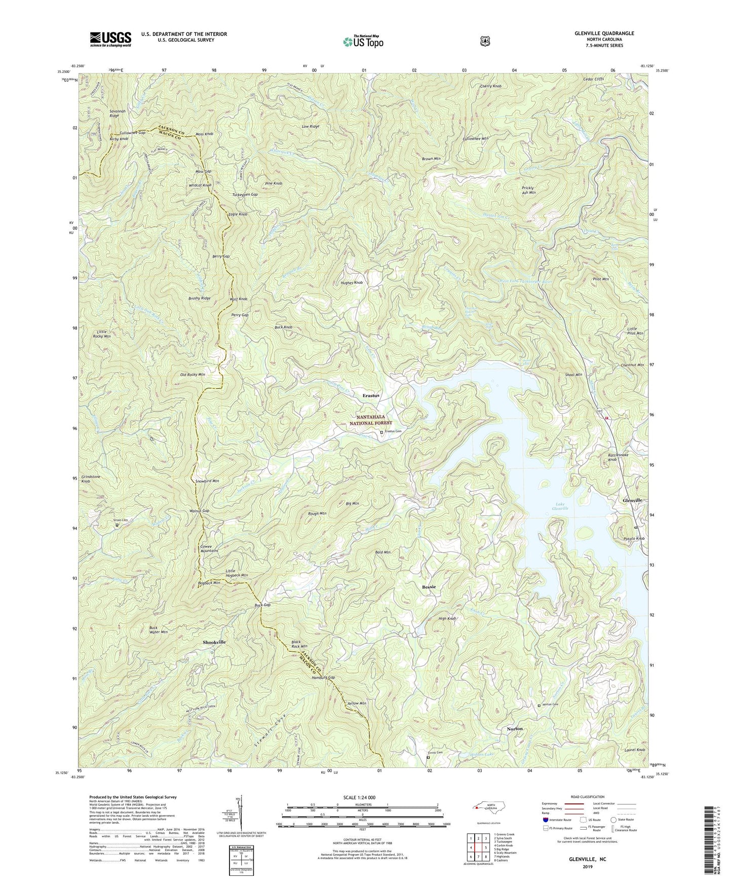
Glenville North Carolina US Topo Map
Couldn't load pickup availability
Also explore the Glenville Forest Service Topo of this same quad for updated USFS data
2022 topographic map quadrangle Glenville in the state of North Carolina. Scale: 1:24000. Based on the newly updated USGS 7.5' US Topo map series, this map is in the following counties: Jackson, Macon. The map contains contour data, water features, and other items you are used to seeing on USGS maps, but also has updated roads and other features. This is the next generation of topographic maps. Printed on high-quality waterproof paper with UV fade-resistant inks.
Quads adjacent to this one:
West: Corbin Knob
Northwest: Greens Creek
North: Sylva South
Northeast: Tuckasegee
East: Big Ridge
Southeast: Cashiers
South: Highlands
Southwest: Scaly Mountain
This map covers the same area as the classic USGS quad with code o35083b2.
Contains the following named places: Allison Lake, Bald Mountain, Bearpen Branch, Berry Gap, Bessie, Betsy Branch, Betsy Falls, Big Mountain, Black Rock Mountain, Brown Mountain, Brushy Ridge, Bryson Branch, Buck Creek Church, Buck Creek School, Buck Gap, Buck Knob, Buck Water Mountain, Cashiers - Glenville Fire Department Station 2, Cedar Cliffs, Cherry Knob, Chestnut Mountain, Coggins Creek, Cullowhee Gap, Cullowhee Mountain, Dodgen Creek, Double Spring Church, Double Spring School, Eagle Knob, Erastus, Erastus Cemetery, Evvitt Cemetery, Flat Creek, Gem Creek, Glenville, Glenville Census Designated Place, Glenville Dam, Glenville Post Office, Grassy Camp Creek, Grassy Creek, Grindstone Knob, Hamburg Church, Hamburg Gap, Hidden Lake, High Falls, High Knob, Hogback Mountain, Hughes Knob, Hunter Jim Creek, Hurricane Creek, Jackson Creek, Joe Creek, Kirby Knob, Knob Creek, Lake Glenville, Laurel Branch, Laurel Knob, Little Buck Creek Church, Little Hogback Mountain, Little Mill Creek, Little Pilot Mountain, Little Pine Creek, Little Rocky Mountain, Little Salt Rock Creek, Low Ridge, Mill Creek, Moss Gap, Moss Knob, Norton, Norton Cemetery, Norton Creek, Old Rocky Mountain, Onion Falls, Perry Gap, Pilot Mountain, Pine Creek, Pine Knob, Potato Knob, Prickly Ash Mountain, Rattlesnake Knob, Rough Mountain, Rough Run, Shoal Creek, Shoal Mountain, Shookville, Snowbird Mountain, Stewart Cove, Strain Cemetery, Taylor Creek, Thorpe Dam, Thurston Hatcher Falls, Township of Mountain, Trout Creek, Tuckasegee Power Plant, Turkeypen Gap, Walnut Gap, Whiterock Creek, Whiterock School, Wildcat Knob, Wilson Creek, Wolf Creek, Wolf Knob, Yellow Mountain, Yellow Mountain Church, Yellow Mountain Fire Tower