MyTopo
Medford East Oregon US Topo Map
Couldn't load pickup availability
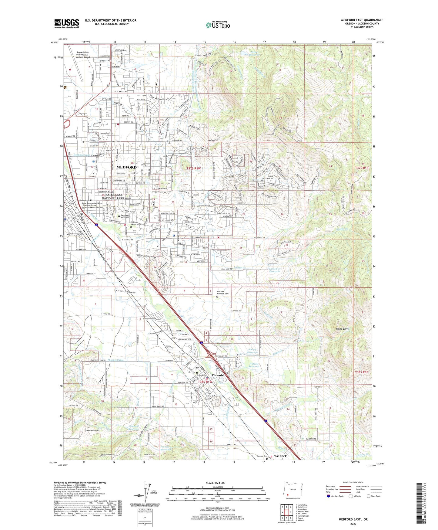
2024 topographic map quadrangle Medford East in the state of Oregon. Scale: 1:24000. Based on the newly updated USGS 7.5' US Topo map series, this map is in the following counties: Jackson. The map contains contour data, water features, and other items you are used to seeing on USGS maps, but also has updated roads and other features. This is the next generation of topographic maps. Printed on high-quality waterproof paper with UV fade-resistant inks.
Quads adjacent to this one:
West: Medford West
Northwest: Sams Valley
North: Eagle Point
Northeast: Brownsboro
East: Rio Canyon
Southeast: Ashland
South: Talent
Southwest: Sterling Creek
This map covers the same area as the classic USGS quad with code o42122c7.
Contains the following named places: Abraham Lincoln Elementary, American Red Cross Medford Donor Center, American Red Cross Southern Oregon Chapter, Anderson Creek, Armadillo Technical Institute, Asante Health Rogue Valley Medical Center Blood Bank, Asante Rogue Regional Medical Center, Barneburg Hill, Bear Creek Junction, Bear Creek Orchards, Bear Creek Park, Buckshot Hill, Camp Baker, Camp Stuart, Central Medford High School, City of Medford, City of Phoenix, Cliff Gulch, Coal Mine Creek, Coleman Creek, Craterian Ginger Rogers Theatre, Crooked Creek, CSL Plasma Services, Department of Motor Vehicles Medford Drive Test Center, Dunkard Cemetery, Eastwood IOOF Cemetery, Eden Valley Orchards, Fern Valley, Francis L Reservoir, Front Street Station Park and Ride, Gammill Reservoir, Gas Works, Gore Creek, Grace Christian School, Greyhound Bus Station, Hansen Creek, Hedrick Middle School, Hillcrest Memorial Cemetery, Hillcrest Orchard, Hilldale Reservoir, Holmes Reservoir, Hoover Elementary School, Jackson County Fire District 5, Jackson County Health and Human Services, Jefferson Elementary School, Jefferson School Park, Kane, KBOY-AM, KBOY-FM, KCMX-FM, Kennedy Elementary School, Kenutchen Creek, KHUG-AM, KISD-AM, KMED-AM, KSOR-FM, Larson Creek, Larson Creek Reservoir, Lazy Creek, Lone Pine Elementary School, Lowry Reservoir, Medford Army Air Field, Medford Branch Library, Medford Fire Department Station 3, Medford Fire Department Station 5, Medford Fire Department Station 6, Medford Police Department, Medford Post Office, Mills Creek, Nelson Reservoir, North Branch Swanson Creek, North Fork Larson Creek, North Medford High School, Orchard Hill Elementary School, Payne Cliffs, Payne Creek, Phoenix, Phoenix Branch Library, Phoenix Cemetery, Phoenix City Hall, Phoenix Elementary School, Phoenix Fire Department, Phoenix High School, Phoenix Historical Society Museum, Phoenix Municipal Court, Phoenix Police Department, Phoenix Post Office, Phoenix Public Works Department Office, Providence Hospital Heliport, Providence Medford Medical Center, Rheinhardt Gulch, Rogue River Siskiyou National Forest Law Enforcement District Headquarters, Rogue Valley Country Club, Rogue Valley Genealogical Society Library, Rogue Valley International - Medford Airport, Rogue Valley International Medford Airport Fire Department, Rogue Valley Memorial Hospital Heliport, Roosevelt Elementary School, Rosenberg Brothers Spur, Roxy Ann Peak, Sacred Heart Catholic School, Saint Mary's School of Medford, Siskiyou Memorial Park, Suncrest Safety Rest Area, Talent Lateral, Talent Middle Canal, The RRRink Southern Oregon Ice Arena, Tombstone, United States Drug Enforcement Administration Medford, Voorhies, Wilson Elementary School, ZIP Codes: 97504, 97535