MyTopo
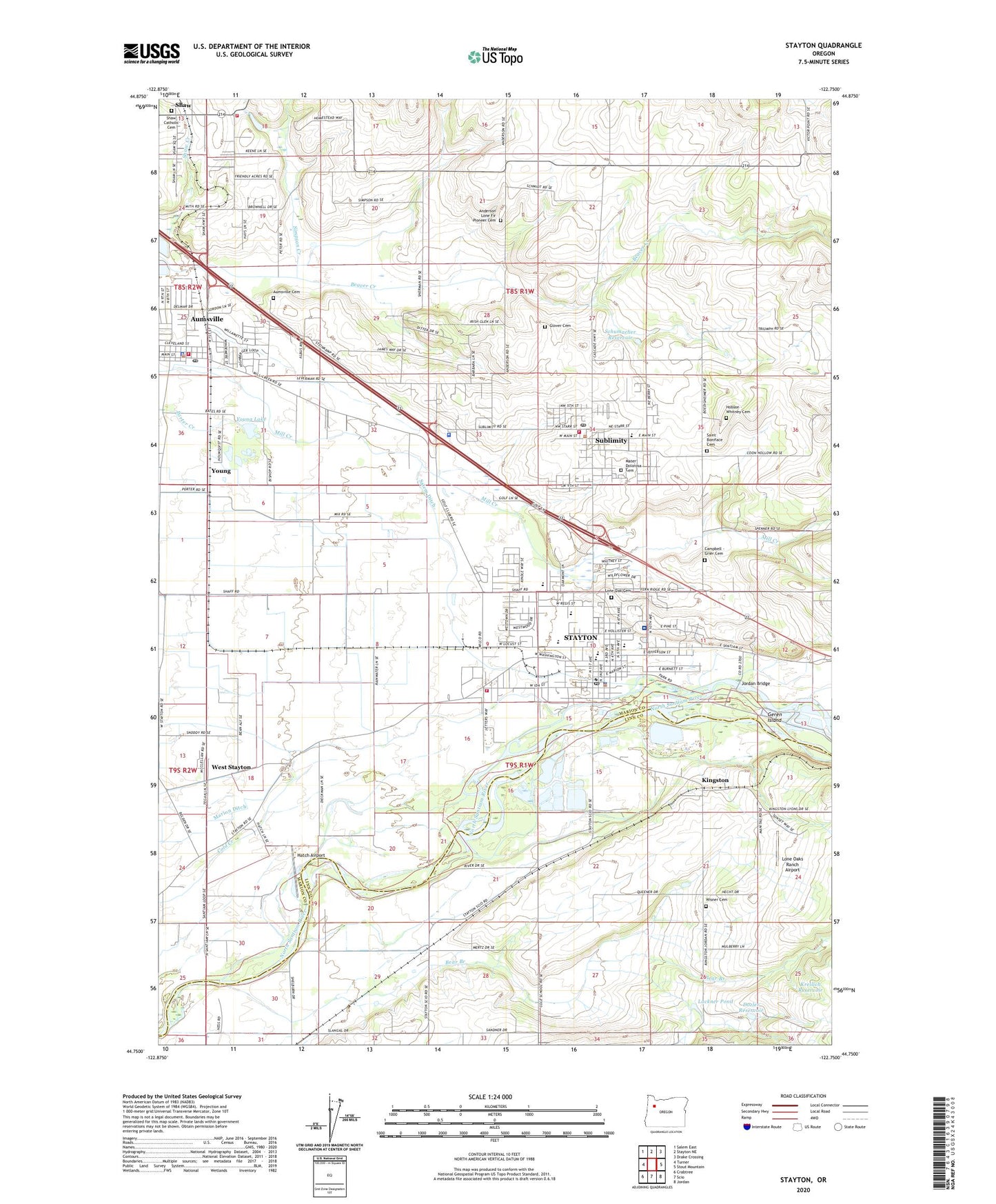
Stayton Oregon US Topo Map
Couldn't load pickup availability
2023 topographic map quadrangle Stayton in the state of Oregon. Scale: 1:24000. Based on the newly updated USGS 7.5' US Topo map series, this map is in the following counties: Marion, Linn. The map contains contour data, water features, and other items you are used to seeing on USGS maps, but also has updated roads and other features. This is the next generation of topographic maps. Printed on high-quality waterproof paper with UV fade-resistant inks.
Quads adjacent to this one:
West: Turner
Northwest: Salem East
North: Stayton NE
Northeast: Drake Crossing
East: Stout Mountain
Southeast: Jordan
South: Scio
Southwest: Crabtree
This map covers the same area as the classic USGS quad with code o44122g7.
Contains the following named places: Ale, Ale Post Office, Anderson Lone Fir Pioneer Cemetery, Aumsville, Aumsville Cemetery, Aumsville Municipal Court, Aumsville Police Department, Aumsville Ponds County Park, Aumsville Post Office, Aumsville Rural Fire District, Aumsville Rural Fire Protection District Substation 670, Aumsville Sewage Treatment Plant, Bear Branch, Buell Miller County Park Boat Ramp, Buell-Miller County Park, Calvary Lutheran Church, Campbell - Grier Cemetery, Cherriots State Highway 22 and Golf Club Road Park and Ride, Chester Bridges Memorial Community Center, Church of God of Prophecy Bible Place, City of Aumsville, City of Stayton, City of Sublimity, Department of Motor Vehicles Stayton, Dozler Reservoir, East Marion Justice Court Stayton, Geren Island, Glover Cemetery, Hatch Airport, Highberger Ditch, Hobson - Whitney Cemetery, Jordan Bridge, Kingston, Kingston Post Office, Kreilich Reservoir, Lackner Pond, Leffler, Lone Oak Cemetery, Lone Oaks Ranch Airport, Lower Bennett Dam, Marion County Sheriffs Department South District, Mater Dolorosa Cemetery, New Hope Community Church, North Santiam, Oakley Farms, Regis High School, Remington, Saint Boniface Catholic Church, Saint Boniface Old Cemetery, Saint Mary Catholic School, Saint Marys Cemetery, Salem Ditch, Santiam Golf Club, Santiam Memorial Hospital, Santiam Memorial Hospital Helipad, Schumacher Reservoir, Shaff, Shaw, Shaw Post Office, Simpson Creek, State Highway 22 and Cascade Highway Southeast Park and Ride, Stayton, Stayton Bridge County Boat Ramp, Stayton Bridge County Park Boat Ramp, Stayton City Hall, Stayton Division, Stayton Elementary School, Stayton High School, Stayton Intermediate School, Stayton Police Department, Stayton Post Office, Stayton Public Library, Stayton Public Works Department Office, Stayton Rural Fire Protection District Stayton Station, Stayton Sewage Treatment Plant, Sublimity, Sublimity City Hall, Sublimity Elementary School, Sublimity Harvest Festival Grounds, Sublimity Post Office, Sublimity Public Works Department Office, Sublimity Rural Fire Protection District, Time Post Office, Troost Dairy, Valentine Creek, Walker Creek, West Stayton, Whiteaker Post Office, Wildwood Park, Willamette Valley Baptist Church, Wisner Cemetery, Young, Young Lake, ZIP Code: 97325