MyTopo
Cheraw South Carolina US Topo Map
Couldn't load pickup availability
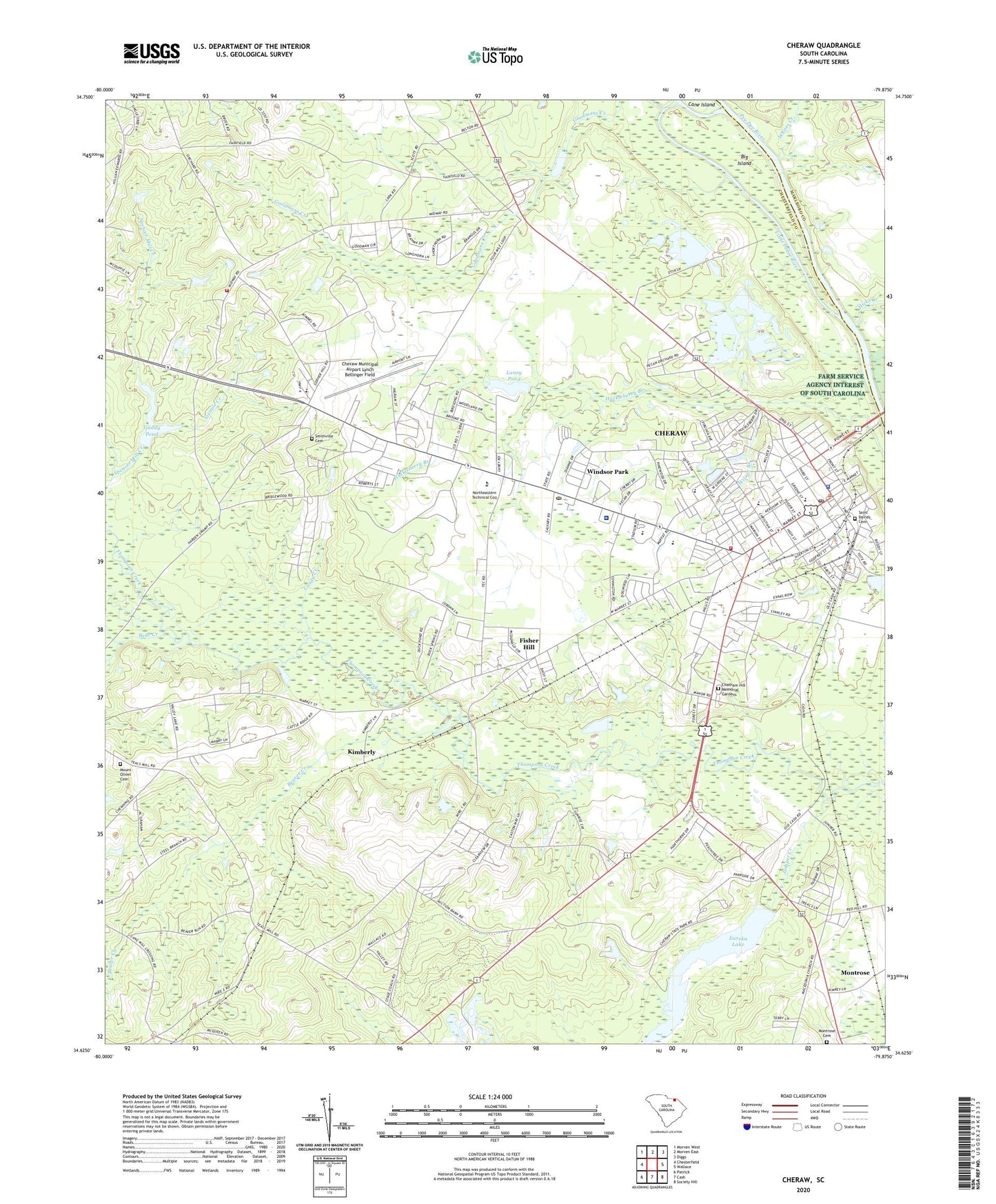
2024 topographic map quadrangle Cheraw in the state of South Carolina. Scale: 1:24000. Based on the newly updated USGS 7.5' US Topo map series, this map is in the following counties: Chesterfield, Marlboro. The map contains contour data, water features, and other items you are used to seeing on USGS maps, but also has updated roads and other features. This is the next generation of topographic maps. Printed on high-quality waterproof paper with UV fade-resistant inks.
Quads adjacent to this one:
West: Chesterfield
Northwest: Morven West
North: Morven East
Northeast: Diggs
East: Wallace
Southeast: Society Hill
South: Cash
Southwest: Patrick
This map covers the same area as the classic USGS quad with code o34079f8.
Contains the following named places: Bear Creek, Beaver Creek, Big Island, Bills Bay School, Bridlewood Lower Lake Dam D-3237, Bridlewood Upper Lake Dam D-3236, Brocks Mill Fire Department Station 2, Cane Island, Caston Park, Chapman Training School, Chatham Hill Memorial Gardens, Cheathan Lake Dam D-3219, Cheraw, Cheraw Academy, Cheraw Center for Performing Arts, Cheraw Church of God, Cheraw Community Center, Cheraw Country Club, Cheraw Division, Cheraw Elementary School, Cheraw Fire Department, Cheraw High School, Cheraw Historic District, Cheraw Municipal Airport/Lynch Bellinger Field, Cheraw National Fish Hatchery, Cheraw Police Department, Cheraw Post Office, Cheraw Primary School, Cheraw Rescue Squad, Cheraw State Park, Cheraw State Park Two Dam D-3224, Cheraw Town Hall, Chesterfield-Marlboro School, Clyde Laney Pond Dam D-3217, Coulter Memorial Academy, Eskridge Pond Dam D-3221, Eureka Lake, Eureka Lake Dam D-3225, Eureka Mill, Excelsior, Faith Church, Faith Presbyterian Church, First Baptist Church, First Presbyterian Church, First Southern Church, First United Methodist Church, Fish Hatchery Lake One Dam D-3222, Fish Hatchery Lake Two Dam D-3223, Fisher Hill, Fishers Hill Church, Fishers Hill School, Forest Pine Independent Baptist Church, Four Mile Branch School, Gaddy Pond, George Waldo Long Memorial Presbyterian Church, Gillespie, Goodman School, Goodmans Creek Baptist Church, Hicks Creek, Holy Temple Church of the Living God, Huckleberry Branch, Husbands Creek, Isgett Circle, Juniper Creek, Kimberly, L C Reid Pond Dam D-3220, Landy Creek, Laney Pond, Little Pedee River, Long Junior High School, Marburg School, Matheson Memorial Library, McColmons Mill, McLeod Health Cheraw Hospital, McNeils, Midway Baptist Church, Midway Church Cemetery, Montrose Cemetery, Montrose School, Mount Hebron African Methodist Episcopal Zion Church, Mount Olivet Cemetery, Mount Olivet Church, Northside Baptist Church, Old Brocks Mill Memorial, Old Saint Davids Church, Orange Hill School, Pats Branch School, Pee Dee River, Pee Dee Union Baptist Church, Pentecostal Holiness Church, Pleasant Grove Church, Pleasant Grove Church Cemetery, Pleasant Grove School, Pleasant Hill Baptist Church, Riverside Park, Robinson, Saint Davids Cemetery, Saint Davids Episcopal Church, Saint James Baptist Church, Saint Paul Baptist Church, Saint Pauls Church Cemetery, Saint Peters Roman Catholic Church, Saint Peters School, Sixmile Creek, Small School, Smithville Cemetery, Smithville Church, Smithville School, South Carolina Noname 13011 D-3216 Dam, Southside Park, Stafford School, Tabernacle Baptist Church, Thompsons, Town of Cheraw, WCRE-AM (Cheraw), Wesley United Methodist Church, Westfield Creek, Westside Baptist Church, Whites Creek, Wilson Branch, Windsor Park, Windsor Park Freewill Baptist Church, Zion Church, ZIP Code: 29520