MyTopo
Marble Falls Texas US Topo Map
Couldn't load pickup availability
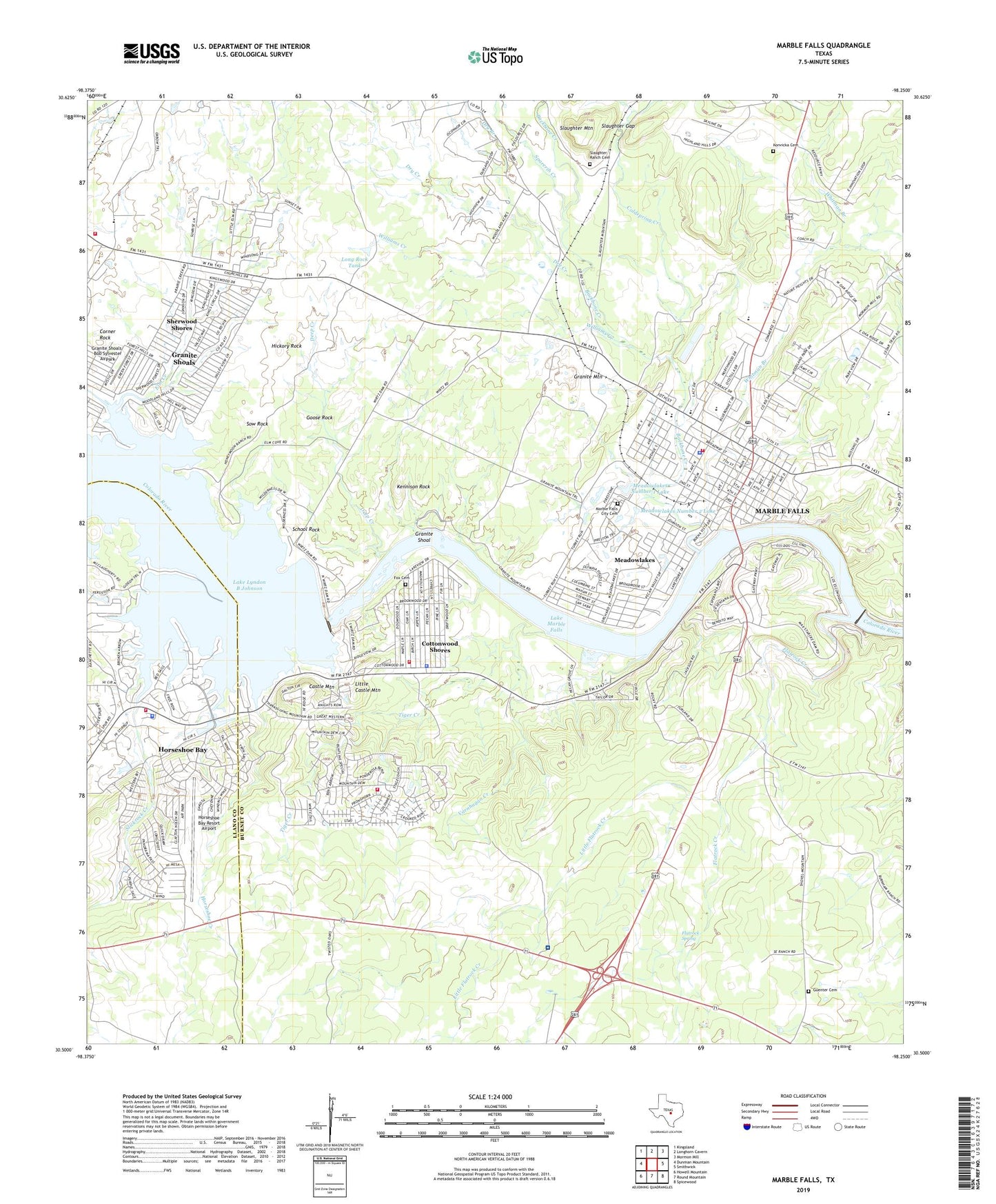
2022 topographic map quadrangle Marble Falls in the state of Texas. Scale: 1:24000. Based on the newly updated USGS 7.5' US Topo map series, this map is in the following counties: Burnet, Llano. The map contains contour data, water features, and other items you are used to seeing on USGS maps, but also has updated roads and other features. This is the next generation of topographic maps. Printed on high-quality waterproof paper with UV fade-resistant inks.
Quads adjacent to this one:
West: Dunman Mountain
Northwest: Kingsland
North: Longhorn Cavern
Northeast: Mormon Mill
East: Smithwick
Southeast: Spicewood
South: Round Mountain
Southwest: Howell Mountain
This map covers the same area as the classic USGS quad with code o30098e3.
Contains the following named places: Air - Evac Lifeteam 49, Alvin Wirtz Dam, Alvin Wirtz Park, Anchor Hope Church, Backbone Creek, Burnet County Constable's Office Precinct 3, Burnet County Constable's Office Precinct 4, C Taylor Rodeo Arena, Castle Mountain, Church of Christ, City of Cottonwood Shores, City of Granite Shoals, City of Marble Falls, City of Meadowlakes, Coldspring Creek, Corner Rock, Cottonwood Shores, Cottonwood Shores Area Volunteer Fire Department, Cottonwood Shores City Hall, Cottonwood Shores Community Center, Cottonwood Shores Police Department, Deep Creek, Dry Branch, Dry Creek, Elm Creek, First Assembly of God Church, First Baptist Church, First United Methodist Church, Flatrock Creek, Flatrock Spring, Fox Cemetery, Goose Rock, Granite Mountain, Granite Shoal, Granite Shoals Fire Department, Granite Shoals/ Bob Sylvester Airpark, Guenter Cemetery, Hickory Rock, Highland Baptist Church, Hill Country Baptist Area Church, Horseshoe Bay, Horseshoe Bay City Hall, Horseshoe Bay Emergency Medical Station, Horseshoe Bay Fire Department Station 1, Horseshoe Bay Fire Department Station 3, Horseshoe Bay Police Department, Horseshoe Bay Resort Airport, Horseshoe Creek, Kelly A F B Recreation Area, Kennison Rock, Konvicka Cemetery, La Iglesia De Cristo, Lake Lyndon B Johnson, Lake Marble Falls, Lakeside Park, Later Day Saints, Little Castle Mountain, Little Flatrock Creek, Llano County Constable's Office Precinct 1, Llano County Courthouse, Long Rock Tank, Marble Falls, Marble Falls Area Emergency Medical Services, Marble Falls Area Emergency Medical Services Satellite Station, Marble Falls City Cemetery, Marble Falls City Hall, Marble Falls City Park, Marble Falls Elementary School, Marble Falls Emergency Medical Station, Marble Falls Fire Rescue Department, Marble Falls High School, Marble Falls High School Auditorium, Marble Falls High School Stadium, Marble Falls Library, Marble Falls Middle School, Marble Falls Police Department, Marble Falls Post Office, Marble Falls Primary School, Marble Falls Volunteer Fire Department, Max Starcke Dam, Meadowlakes, Meadowlakes City Hall, Meadowlakes Number 1 Dam, Meadowlakes Number 1 Lake, Meadowlakes Number 2 Dam, Meadowlakes Number 2 Lake, Protestant Church, Roper Hotel, Saint Andrew Presbyterian Church, Saint Johns Catholic Church, Saint Paul the Apostle Catholic Church, School Rock, Sherwood Shores, Sherwood Shores Census Designated Place, Slaughter Gap, Slaughter Mountain, Slaughter Ranch Airport, Slaughter Ranch Cemetery, Slickrock Creek, Sow Rock, Sparerib Creek, Starcke Dam Electric Substation, The Driftwood Theater 8, Tiger Creek, Trinity Episcopal Church, Varnhagan Creek, Westside Baptist Church, Whitman Branch, Williams Creek