MyTopo
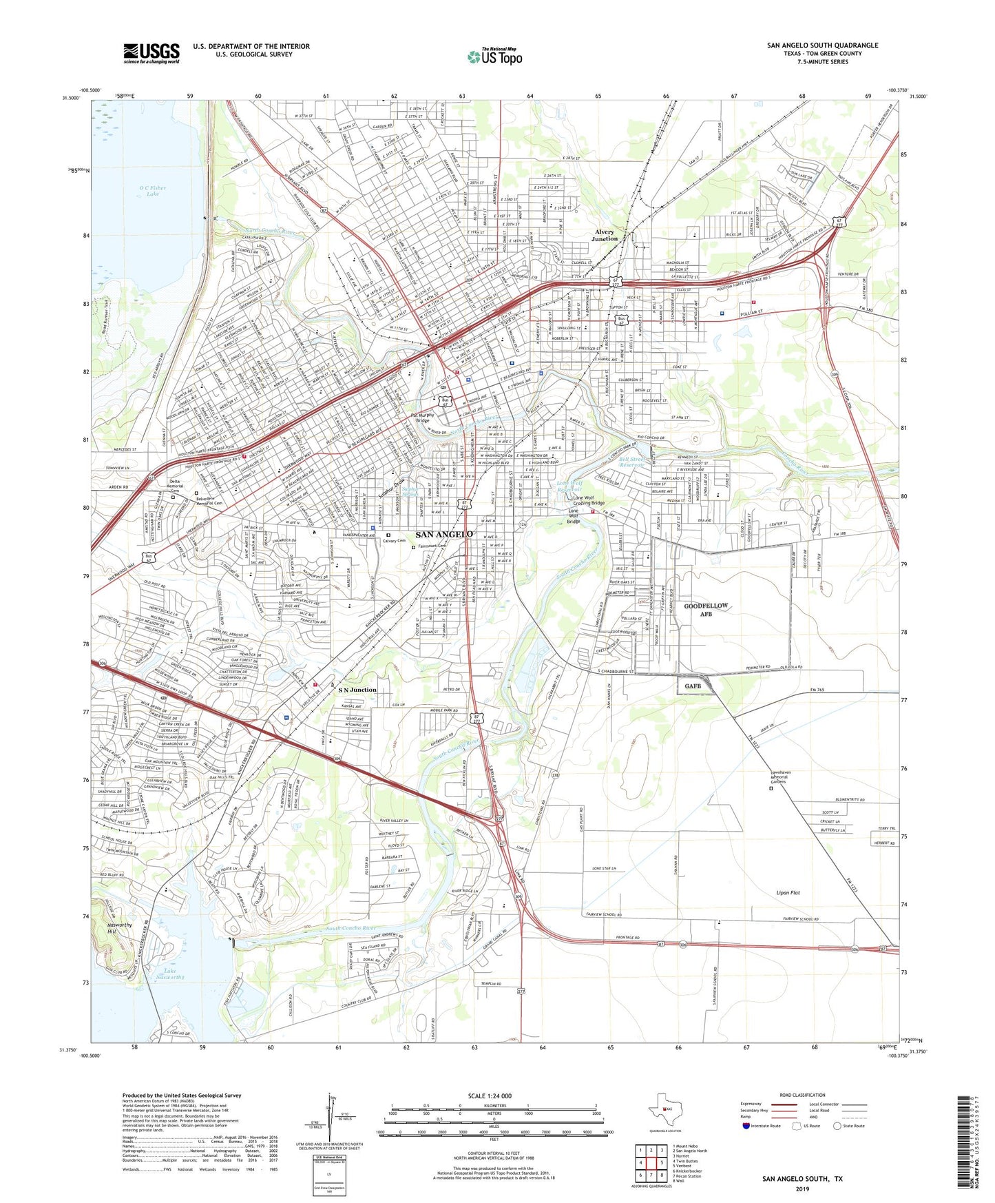
San Angelo South Texas US Topo Map
Couldn't load pickup availability
2022 topographic map quadrangle San Angelo South in the state of Texas. Scale: 1:24000. Based on the newly updated USGS 7.5' US Topo map series, this map is in the following counties: Tom Green. The map contains contour data, water features, and other items you are used to seeing on USGS maps, but also has updated roads and other features. This is the next generation of topographic maps. Printed on high-quality waterproof paper with UV fade-resistant inks.
Quads adjacent to this one:
West: Twin Buttes
Northwest: Mount Nebo
North: San Angelo North
Northeast: Harriet
East: Veribest
Southeast: Wall
South: Pecan Station
Southwest: Knickerbocker
This map covers the same area as the classic USGS quad with code o31100d4.
Contains the following named places: Alta Loma Elementary School, Alvery Junction, Ambleside School of San Angelo, Angelo Community Hospital Heliport, Angelo Heights Historic District, Angelo State Multipurpose Sports Complex, Angelo State Soccer Field, Angelo State University, Angelo State University Police Department, Angelo State University Softball Field, Angelo West Branch Library, Austin Elementary School, Aztec Cleaners and Laundry Building, Belaire Elementary School, Bell Street Dam, Bell Street Reservoir, Belmore Baptist Church, Belvedere Memorial Cemetery, Belvedere Memorial Park, Ben Ficklin Dam, Ben Ficklin Reservoir, Blackshear Elementary School, Blackshear High School, Bobcat Stadium, Bradford Elementary School, Bradford Park, Bradford School, Brentwood Park, Browns Chapel Methodist Church, C A Broome House, C C Walsh House, Calvary Cemetery, Calvary Lutheran Church, Carver Alternative Learning Center, Carver School, Central Evangelistico Pentecost Church, Central High School, Christ Lutheran Church, Christadelphian Church, Church of God, City of San Angelo, Civic League Park, Clayton House, College Hills Park, Collyns House, Cornerstone Christian School, David Crockett Elementary School, Day Elementary School, Day Memorial United Methodist Church, Day School, Deliverance Tabernacle Church of God in Christ, Delta Memorial Cemetery, Delta Memorial Park, Develin House, Doctor Herbert A Wardlaw House, Doctor M M Woodward House, E H Danner Museum of Telephony, Eckert House, Edison Junior High School, Fairmount Cemetery, Fairview Accelerated Learning Center, Fairview Accelerated School, Fairview Accelerated School - Christoval, Fairview Behavior Adjustment Center, Fairview Behavior Adjustment School, Fairview Church, Fairview School, Fannin Elementary School, Fort Concho Elementary School, Fort Concho School, Foster Field, Frederick Beck Farm, Freeze Building, Glenmore Elementary School, Glenmore Park, Glenmore School, Goliad Elementary School, Goodfellow Air Force Base, Goodfellow Air Force Base Post Office, Grace Church, Greek Orthodox Church, Guadalupe School, Guinn Field, Hagelstein Commercial Building, Hammond School, Hilton Hotel, Holcomb-Blanton Print Shop, Holiman Elementary School, Holiman School, Household Furniture Company Building, Howard College, J B Blakeney House, J J Rackley Building, J T and Minnie McClelland House, James Bowie Elementary School, John and Anton Willeke House, John C Westbrook House, John H. Glenn Junior High School, John Willeke Junior House, John Willeke Senior House, Johnson and Taylor Building, Johnson Dam, Johnson Reservoir, KAYJ-AM (San Angelo), KBIL-AM (San Angelo), KGKL-AM (San Angelo), KGKL-FM (San Angelo), Kirby Dam, Kiwanis Park, KIXY-FM (San Angelo), KTEO-AM (San Angelo), Lake Nasworthy, Lakeview Park, Lamar School, Lawnhaven Memorial Gardens, Lee Junior High School, Lindell Avenue Church, Lone Wolf Bridge, Lone Wolf Crossing Bridge, Lone Wolf Dam, Lone Wolf Reservoir, Mason-Hughes House, Masonic Lodge 570, McGill Elementary School, McGill School, Metcalfe Dam, Metcalfe Lake, Monogram Square, Montgomery Ward Building, Mount Calvary Fellowship Church, Murrah House, Nasworthy Dam, Nasworthy Hill, New Hope Church, New Jerusalem Church of God in Christ, North Concho Park, North Concho River, O C Fisher Dam, O C Fisher Federal Building, Oakes Hotel Building, Our Redeemer Ev Lutheran Church, Pat Murphy Bridge, Pays Alternative School, Picnic Bend Park, Princess Ice Cream Company Building, R A Hall House, R Wilbur Brown House, Reagan Elementary School, Reagan School, Red Arroyo, Rio Concho Park, Rio Vista Elementary School, Rio Vista Park, Rio Vista School, Robert E Lee Junior High School, S L Henderson House, S N Junction, Sacred Heart School, Saint Lukes Church, Saint Marys School, Sam Houston School, San Angelo, San Angelo City Hall, San Angelo City Park, San Angelo Community Medical Center, San Angelo Country Club, San Angelo Division, San Angelo Emergency Corps Ambulance, San Angelo Fire Department, San Angelo Fire Department Station 3, San Angelo Fire Department Station 4, San Angelo Fire Department Station 5, San Angelo Fire Department Station 7, San Angelo Fire Training Academy, San Angelo Gun Club, San Angelo High School Stadium, San Angelo Marshal's Office, San Angelo Museum of Fine Arts, San Angelo National Bank Building, San Angelo Police Department, San Angelo Post Office, San Angelo Telephone Company Building, San Angelo Yard, San Jacinto Elementary School, San Jacinto School, Santa Fe Park, Santa Fe Passenger and Freight Depot, Santa Rita Elementary School, Santa Rita Park, Shannon Business Services, Shannon Medical Center, Shannon Medical Center - Saint John's Campus, Shannon West Texas Memorial Hospital, Shepperson House, Sierra Vista United Methodist Church, South Concho Park, South Concho River, Southwest Post Office, Spanish Park, State Fish Hatchery Number 1, State Fish Hatchery Number 2, Stephen F Austin School, Sulphur Draw, Sulphur Springs, Sulphur Springs Park, Sunken Gardens, Sunset Shopping Center, Texas Forest Service San Angelo Office, Texas Highway Department Building, Texas Highway Patrol Office - San Angelo, Texas Parks and Wildlife Department Law Enforcement Center, The Junell Center, Thomas A Edison Junior High School, Tom Green County, Tom Green County Constable's Office Precinct 1, Tom Green County Constable's Office Precinct 2, Tom Green County Constable's Office Precinct 3, Tom Green County Constable's Office Precinct 4, Tom Green County Courthouse, Tom Green County Jail, Tom Green County Sheriff's Office, Travis Elementary School, Trinity Early Childhood Center, Trinity Fellowship Church, Trinity Lutheran School, Trinity School, Trinity United Methodist Church, United Methodist Church, United Pentecostal Church, United States Marshal's Service, Wesley United Methodist Church, West Texas Utilities Office, William Schneemann House, ZIP Codes: 76903, 76908